
Indicators
Recommendations
Summary
of Concerns
Suggestions
for Further Work
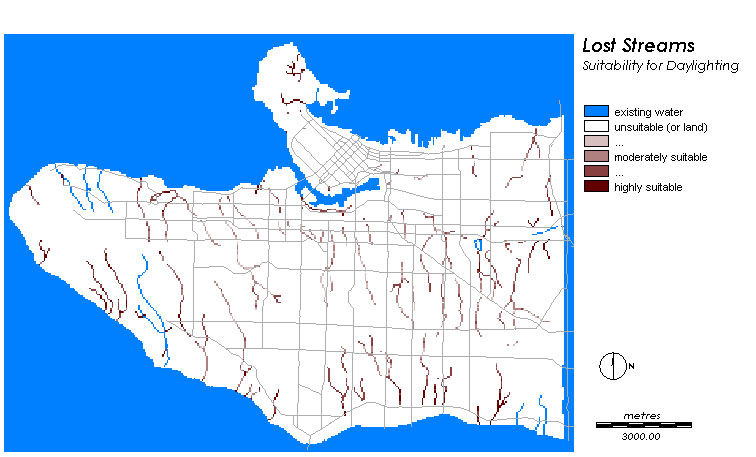
Simply looking at a map showing lost streams can be a liberating experience,
and relates well to the bioregional movement. Streams, after all, know
no boundaries, and looking at a map like the one below helps us to think
about space and natural processes inspace in new ways.
In our daily lives, surrounded by built environments, we often forget where
all of it came from. Looking at an image like the one below is a bold statement
for some; it reminds us that the city was
already "green" before
we arrived in great numbers! When planners and policy-makers speak of "greening
the city", we are reminded by images like this that there exists a "wild"
landscape still, hidden under the asphalt and neatly mowed front lawns
of modern-day Vancouver.
Perhaps efforts to "green the city" should instead begin by speaking about
"reclaiming" formerly natural spaces, and allowing ecological processes
to continue within urban areas.

The MCE images produced in the preceeding section were combined to produce the "suit" image below, which shows the overall areal suitability for urban stream restoration. Note that the numbers are shown in real data here. The results were in byte format, but were converted for the purposes of this display (to create a continuous legend). Note also that these values are in unassigned units (interval data) and therefore should be understood on a relative basis only.

"Suit" was then overlaid with the image below, "loststreams":

... to get the following image of streams and their suitabilities: "canudigit":

The image below, suitmap, shows the product of this analysis. Which streams are more suitable for daylighting? Given all of the constraints listed in previous sections, how should we select which stream to daylight? The map below is a useful tool:
Below is a histogram showing the distribution of suitability indicies along each of these streams.
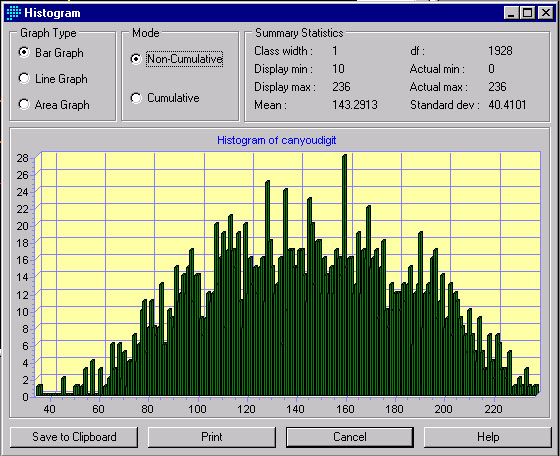
Note that the histogram
shows a fairly normal distribution of suitability. We see some extreme
values, but we should be very careful at reading "too far" into this data,
as it was derived from other maps at lower resolutions. That would be akin
to including seven decimal places when only two "significant figures" are
called for. The general trend here is encouraging, we see a great many
sections of stream that are moderately suitable.
In looking at the streams
as a whole, we see that those streams currently within parks are deemed
the most suitable in general. This is not simply because parks were weighted
in an MCE, but because it likely also coincides with several othr factors
including land use, slope, proxmity to bikeway, and many others.
A good indicator of the
sucess of this study is that there are currently daylighting projects in
planning for Brewery Creek (Mount Pleasant) and a creek in Kitsilano -
both of which rate highly on the above suitability index.
Also it should be noted
that BC Hydro is currently sponsoring a daylighting of a stream in Stanley
Park - a stream that was rated extremely suitable in the above analysis.
It is therefore the recommendation
of this study that two additional creeks be daylighted - the ones which
show the next highest suitability values on the above map. One of these
would be a stream in Everett Crowley Park near the southeast corner of
the city. This would be ideal, as this is a recently dedicated park. parts
of it, interestingly, were previously used the municipal landfill for Vancouver
until the early 1960s. The non-landfill areas festure lush hemlock and
red alder forests, and the landfilled areas are fields, berry bushes, and
low-lying vine maple and red alder.
The second stream that
should be daylighted can be selected here, however a more definitive descision
should wait for an analysis which includes more relevant data concrning
rainfall. The second recommendation would be an additional stream in South
Vancouver - however this result may be unduly influenced by the aspect
data, which was only included as an imperfect surrogate for rainfall. This
second recommendation, therefore is weak and should not be heavily relied
upon.
These concerns have been metioned thusfar in the text, but will be summarized here for convenience: