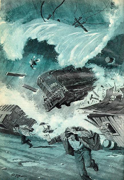
 This
image is from a 1972 Popular Science and was created based on eye witness
accounts of the tsunami that inundated Seward, Alaska as a result of the
1964 earthquake.
This
image is from a 1972 Popular Science and was created based on eye witness
accounts of the tsunami that inundated Seward, Alaska as a result of the
1964 earthquake.
Tsunamis and Their Effects on Ancient Cultural Coastal Sites
An attempt to model the areas affected
by tsunami waves and verify using archeological records for Prince William
Sound in Alaska.
Introduction
Off the southern coast of Alaska lies a tectonic plate subduction zone. When movement occurs the displacement of land due to uplift, subsidence, or landslides (triggered above or below the water) may create fast moving waves called tsunamis. One example is an earthquake in 1964 that resulted in major uplift of parts of the sea floor running through Prince William Sound. This earthquake was the largest in recorded North American history, at 8.9 on the Richter scale, producing tsunami waves that caused $450 million in damage to the Alaskan coast, $10 million (in US dollars) in damage to the Canadian west coast, and $20 million in damage to the US west coast. Landslides, triggered by the earthquake, created waves (also considered tsunami waves) that reached up to 115 feet (35 meters) in height and washed as far inland as 170 feet (67 meters). Although the Alaskan coast was sparsly populated at the time there is currently growing development and settlement for which hazard assessment is extremely important.
This
image is from a 1972 Popular Science and was created based on eye witness
accounts of the tsunami that inundated Seward, Alaska as a result of the
1964 earthquake.
My involvment with this topic came from meeting with Deirdre Dobson, a graduate student in geography here at Simon Fraser University, who is investigating archeological records to see how tsunami waves affected ancient cultures on Alaska's south coast. We decided I would use a subset of her data to see how practical GIS would be for her research.
After looking through Deirdre's
data I decided the best approach (and more interesting for me) would be
to try and model the areas affected by tsunamis then overlay the site information
to see if they fell in the modeled areas. In this case tsunamis are
recorded by lenses or thin layers of sand marking a boundary between two
similar layers, or marking the end of a cultural layer. The site
layers included examples without records of tsunami activity for comparison
with the modeled area.