Introduction Climate change is resulting in shifts in hydrologic regimes that are increasingly accompanied by intensified extremes, including heavy rain events and prolonged drought periods. Watersheds in mountainous regions are particularly vulnerable to climate change given their currently snowmelt-dominated headwater hydrologic regimes. Continued warming is expected to have large impacts on snowmelt hydrology, especially due to snow droughts. How can water be effectively managed in these sensitive watersheds in the face of climate change? This question is at the forefront of scientific research, adaptation planning, and policy/regulation development. The underpinnings of water management are being challenged, as decision makers struggle to balance the needs of growing populations and environmental protection. Over the past several years, we have been studying how groundwater responds to the effects of extreme climate (heavy rain events and drought). Our studies have included field and numerical modeling studies focused on several regions of mountainous British Columbia. | ||
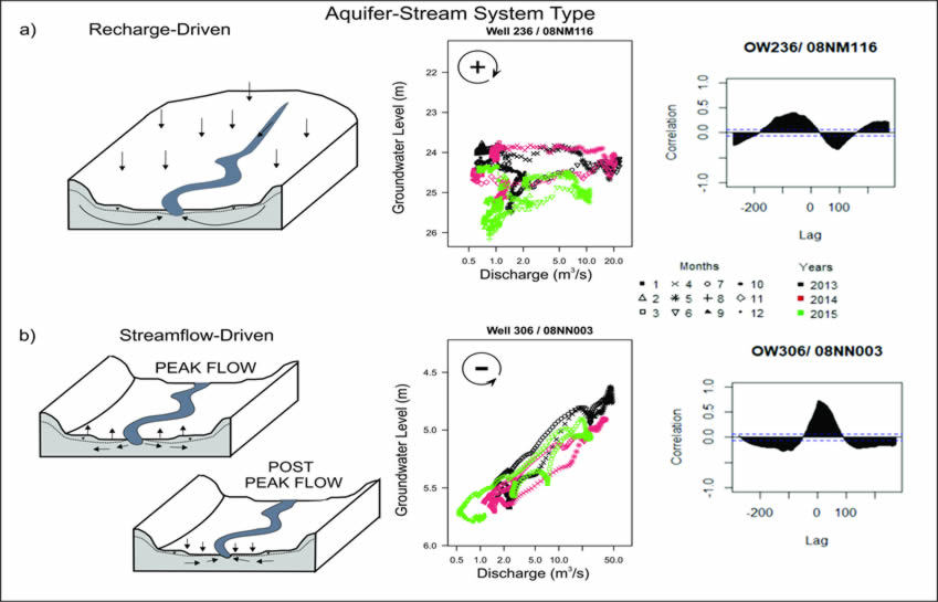
Classification of Groundwater Response Mechanisms While seasonal variations in climate are a dominant signal in groundwater level hydrographs, so is the potential hydraulic signal from nearby surface water bodies, such as rivers, particularly when those rivers are allogenic (meaning their source is remote) and as such are influenced by climatic conditions outside the immediate area of the aquifer. To better understand how an aquifer system responds to climate variability, it is necessary to first understand what factors influence the groundwater levels. This study aimed to classify the groundwater level responses measured in B.C. Provincial Groundwater Observation Well Network (PGOWN) monitoring wells according to the dominant response mechanism (recharge-driven or streamflow-driven), as defined by Allen et al. (2010). Practically, the goal was to identify which signal leads: the groundwater signal or the streamflow signal. Ultimately, the two response mechanisms represent end members of a continuum of responses that reflect the relative contribution of diffuse recharge to the influence of streamflow on groundwater levels. The classification results can be used for a variety of purposes to support hydrogeological investigations and water allocation decision-making Final Report: Gullacher et al. (2021) | Aquifer Response Mechanism
Schematic diagram showing the two end-members of aquifer-stream systems: a) recharge-driven systems and b) streamflow-driven systems. Beside each schematic are example hysteresis and cross correlation plots used to characterize the response mechanisms. In recharge-driven systems, changes in streamflow lag behind changes in groundwater level creating a positive or clockwise hysteresis loop. In streamflow-driven systems, the water flows from the stream to the aquifer during peak flow, and from the aquifer to the stream post peak flow. Therefore, changes in the groundwater level lag behind changes in the streamflow, creating a negative or counter-clockwise hysteresis loop (data from Province of B.C. Observation wells 236 and 308, and Environment and Climate Change Canada hydrometric stations 08NM116 and 08NN003). |
|
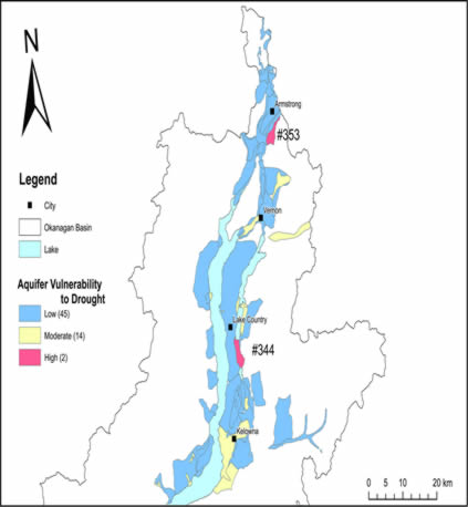
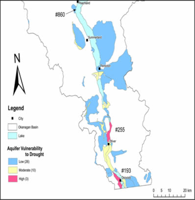
Groundwater Susceptibility to Drought In this study, Generalized Additive Models (GAMs) were used to identify climate and hydrological variables that are most associated with summer groundwater levels in each of a snowmelt-dominated and rainfall-dominated region of British Columbia. In the South Central Interior of BC, the combination of low maximum snow water equivalent, high maximum spring temperature and higher winter Nino 3.4 index is most strongly associated with low summer groundwater levels. In the Fraser Valley, the combination of high maximum spring temperature, low winter precipitation, and low spring streamflow is most strongly associated with low summer groundwater levels. An approach for mapping the drought susceptibility of aquifers was also developed and used in the Okanagan Basin. Final Report: Gullacher et al. (2023) |
Aquifer Drought Susceptibility for the North Okanagan Basin.
|
Aquifer Drought Susceptibility for the South Okanagan Basin. Aquifer #860 borders Okanagan Lake at the edge of Aquifer #861. |
Groundwater Response to Extreme Climate Events This study is investigating the impact of extreme climate events, specifically atmospheric river (AR) events and drought, on the groundwater sysstem, along with interactons between groundwater and surface water. The study uses a combination of empirical analysis of groundwater level data and integrated hydrological models of watersheds in three climate regions of British Columbia.
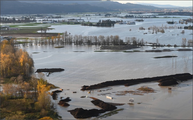
Fraser Valley Flooding due to an Atmospheric River in November 2021. |
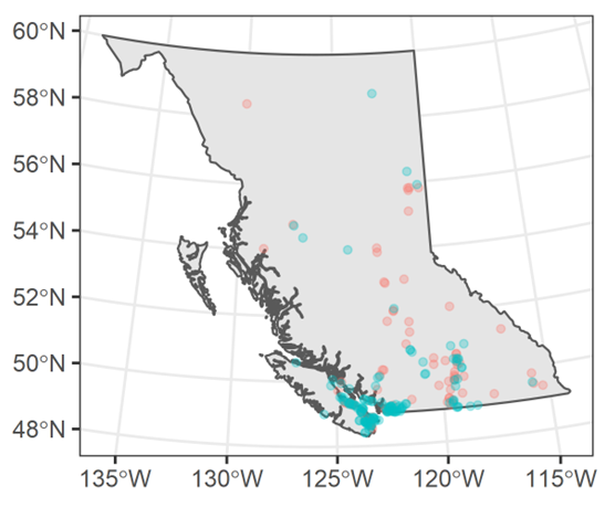
2021 Summer Drought
Following the 2021 summer drought and heatwave, 139 wells (62%) recorded either their lowest, or near-lowest groundwater levels on record (turqouise points). Research in progress by Alexandre Nott |
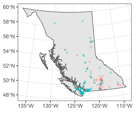
Fall & Winter 2021 Atmospheric Rivers
Following the 2021 atmospheric rivers, 120 wells (53%) recorded either their shallowest, or near-shallowest, groundwater levels on record. |
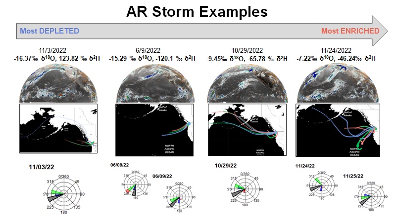
Atmospheric River (AR) Events and Nitrate Contamination This study is focused on attempting to fingerprint ARs using information on the storm characteristics and trajectories, as well as the stable isotope composition of the precipitation. Waters were also sampled during and following precipitation events in a dominantly agricultural watershed, and analyzed for their isotopic composition and nitrate concentration. Data are being used alongside numerical modeling to determine how AR events may impact nitrate mobilization.
|
Research in progress by Ariel Greenblat |
|
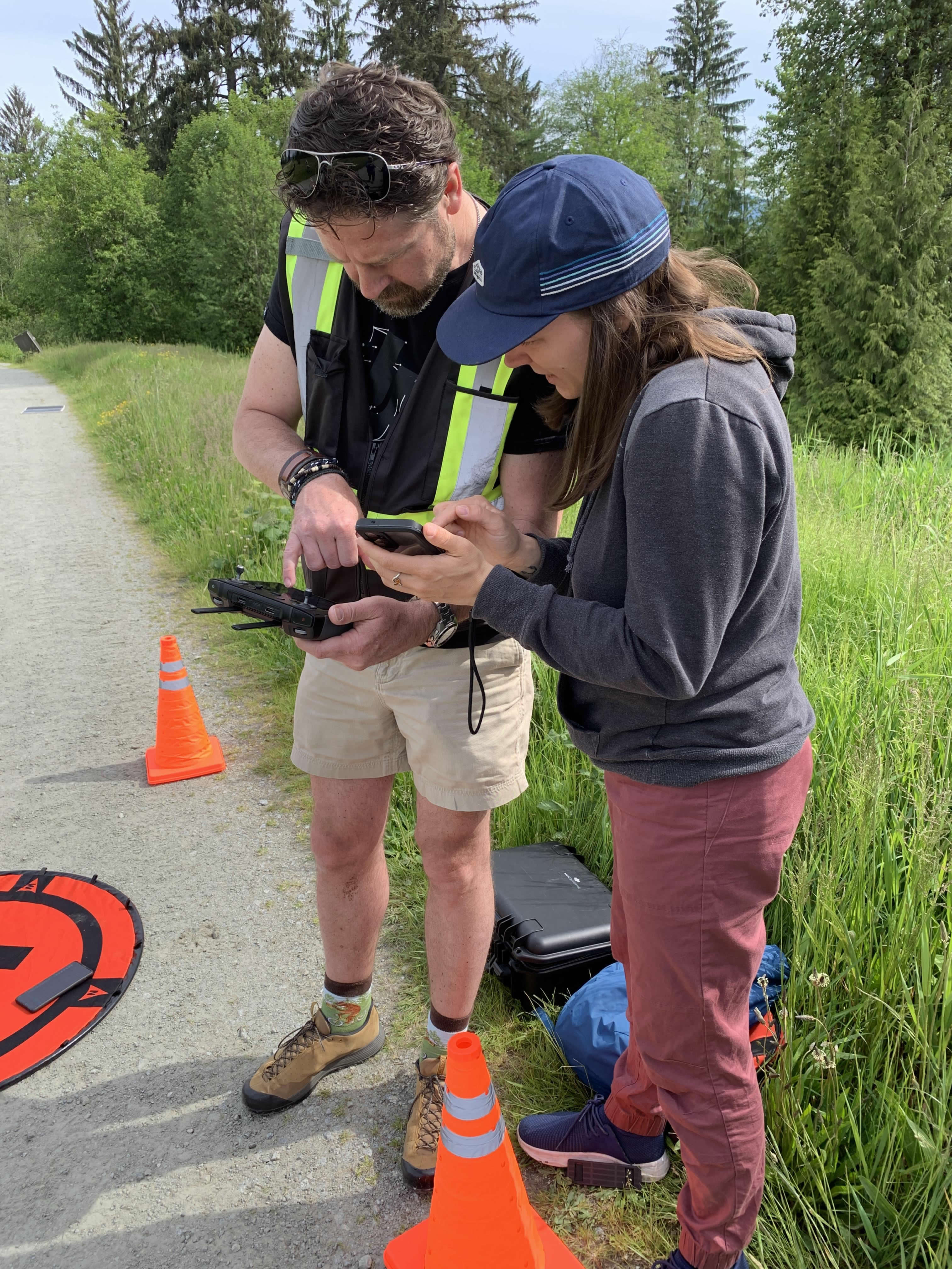
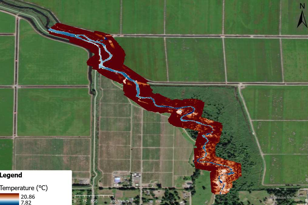
Groundwater Drought and Stream Temperature Drought impacts many components of the hydrologic cycle, including a reduction in groundwater levels and potentially a reduction in stream baseflow. An increase in stream temperature often accompanies a reduction in baseflow. This study compares the use of in situ temperature loggers, drone-mounted thermal infrared (TIR) and satelite (Landsat) TIR for measuring stream temperature. Advanced data processing techniques are being developed along with comparing stream temperatured during early summer and late summer (drought) conditions. |
Drone Survey - North Alouette River, BC
|
Thermal infrared composite image constructed from four drone flights over the North Alouette study reach in June 2022.
Research in progress by Lea Antesz |
Collaboration and Funding Our research has been funded by the Canadian Mountain Network (CMN), the Pacific Institute for Climate Solutions (PICS), NSERC, and the Province of British Columbia Groundwater Science Program. Partners include BC Ministry of Forests (South Coast Region), The Pacific Salmon Foundation, and the British Columbia Institute of Technology (BCIT).
| ||