Introduction In areas where energy resources, such as shale gas, are undergoing rapid development, water security and the associated risks to water quality and quantity are of paramount concern. However, in many regions there is a lack of understanding and data on the hydrologic system, particularly its vulnerability to hazards. The data and knowledge gap poses challenges for effective regulation of the shale gas activities and management of water resources. |
||
Scope of Study Over the past several years we have been conducting hydrogeological studies in Northeast British Columbia (NEBC) to assess various impacts of shale gas development on water resources. Water resources are of particular concern in terms of risk of contamination during the extraction phase and the cumulative effects of large withdrawals from watersheds in the vicinity of drill sites. Shale Gas Development in NEBC was used as a case study for evaluating risk and resilience in the context of the Water-Energy-Food Nexus. |
||
The Study Area NEBC is a vast region extending from the mountains to the west, through to the foothills and low-lying flat areas to the east where the majority of the population resides and where shale gas development is focused. The climate varies from cold continental in the south to cold subarctic in the north, and is characterized by sustained cold winters and warm summers. Average monthly temperatures for November to March are below freezing. Temperatures are relatively uniform across the region, with average daily temperatures ranging between -20°C to +17°C. Annual average precipitation ranges from 400 to 2000 mm/year, with higher precipitation rates in the mountainous western portions of the study area than in the relatively flatter eastern portions. The hydrologic regime is typically snowmelt dominated, with a sustained cold winter period characterized by low river discharge and competent river ice. The spring freshet extends from approximately mid-April to late June and is characterized by high river discharge due to melting snow. After the spring freshet period, river levels generally recede slowly through the summer and autumn until the winter freeze-up. Frontal or convective storm systems bring varying amounts of rain from late spring to autumn, often resulting in increases in river levels and discharge, and occasionally flooding. For much of NEBC, there is a dearth of hydrometric measurements to directly support decision-making regarding water allocation. Groundwater information is very limited throughout the region. Until recently, few hydrogeological data were available for characterizing the shallow and deep aquifer systems. The unconsolidated aquifers, comprised of glacial or pre-glacial origin, are generally of limited extent and groundwater is often sourced from bedrock aquifers. Groundwater level monitoring occurs at seven provincial observation wells, three of which became active in 2012. |
||
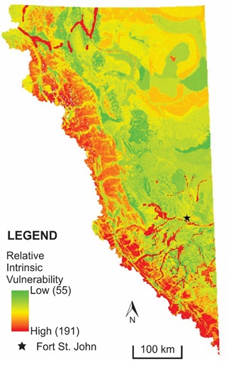
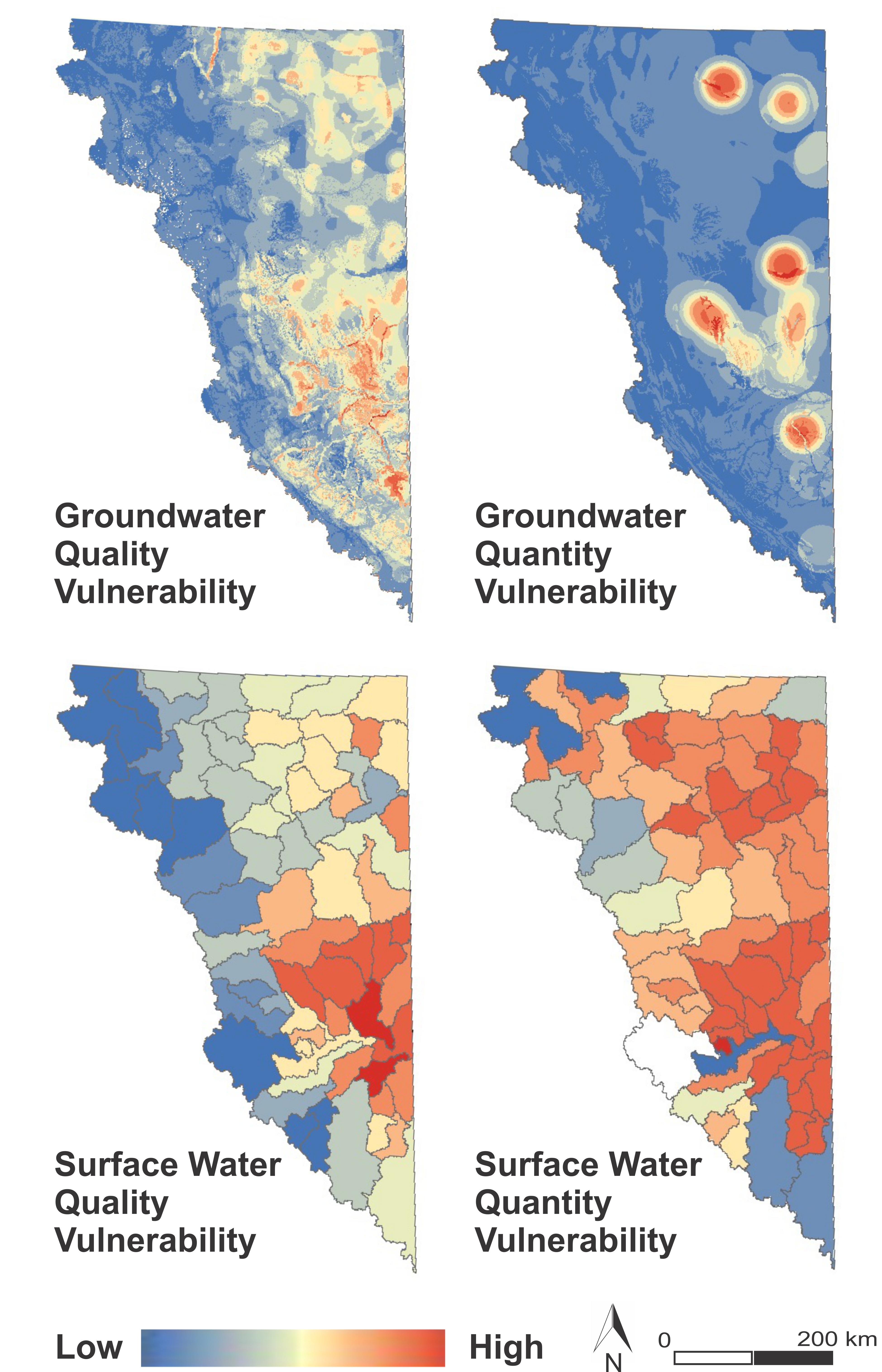
Groundwater and Surface Water Quality and Quantity Vulnerability Mapping The DRASTIC method was used to map the intrinsic susceptibility of shallow (< 30 m) geological materials (i.e. shallow groundwater) throughout NE BC. Areas of higher vulnerability are shown in red with areas of lower vulnerability in green. Areas of higher vulnerability are predominantly present along the mountainous western edge of the region. Here, the higher vulnerability is the result of generally shallow water tables combined with high recharge rates, high permeability weathered bedrock, and limited soil cover. Other higher vulnerability areas include river valleys where the vadose zone and aquifer media have large proportions of sand and gravel. It should be noted that the results represent the relative assessment of intrinsic vulnerability, so that areas ranked low are still vulnerable to surface contamination, although they are relatively less vulnerable than other parts of the study area. The DRASTIC map was then combined with oil and gas related hazards to produce the shallow groundwater quality vulnerability map (top left of 4 maps). Vulnerability represents the combination of a specific hazard threat (here, the density of oil and gas facilities, wells, pipelines) and the susceptibility of the water system to that threat. Hazard-specific vulnerability mapping was then expanded to include surface water quality, and groundwater and surface water quantity. Table 1 in the technical report by Holding et al. (2018) summarizes the approaches used. |
Shallow Groundwater Intrinsic Susceptibility Map The DRASTIC score within the study area ranges from 55 to 191. Final Report (Holding and Allen, 2015) GIS Data (Holding and Allen, 2015)
Vulnerability Maps Groundwater and Surface Water Quality and Quantity Vulnerability Mapping in Northeast British Columbia : Holding, S. McKoen, Z. and Allen, D.M. (2018). Technical Report submitted to BC Oil and Gas Commission. Department of Earth Sciences, Simon Fraser University, Burnaby, BC, 17 pp.
|
|
Vulnerability to Wastewater Spills and Leaks This study utilized numerical modelling of spills and leaks of wastewater into the shallow subsurface to identify areas most vulnerable to groundwater quality deterioration in NEBC. Modelling was conducted using the flow and transport code TOUGH2. The models were designed to address three main factors identified from the DRASTIC method for vulnerability assessment: (1) Depth to water, (2) Impact of vadose zone, and (3) Conductivity of the aquifer materials. Models show that dense saline wastewater will migrate further and faster through highly permeable materials. Lower permeability materials attenuate the wastewater migration resulting in smaller plumes with locally higher brine concentrations. Rosales-Ramirez, T.Y. (2020) Modelling Wastewater Spills and Mapping Areas Most Vulnerable to Groundwater Quality Deterioration in Northeast British Columbia. MSc. Thesis, Simon Fraser University. |
|
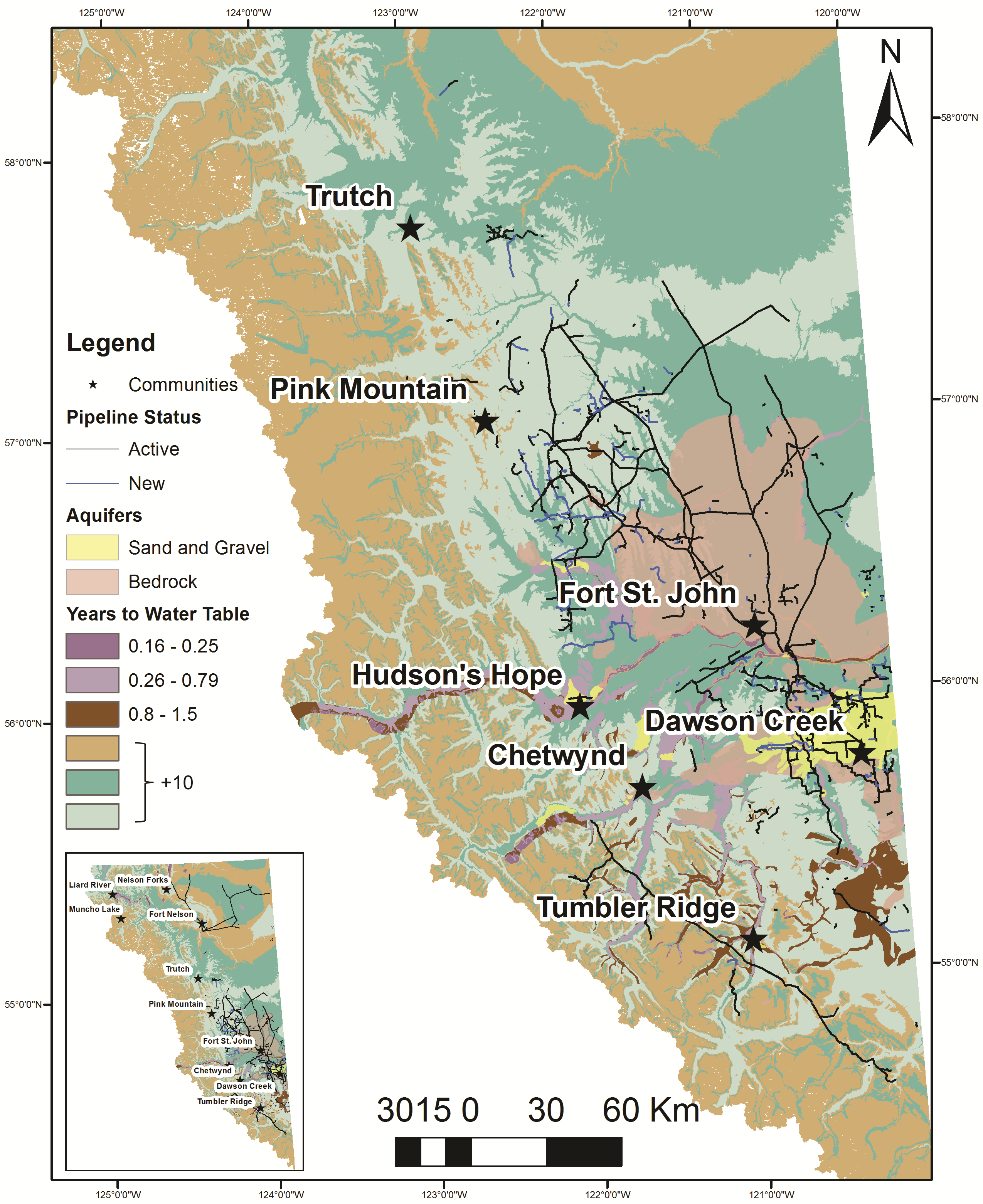
Figure shows the time of travel (in years) to the water table. Rapid travel times are associated with coarse grained sediments located primarily in river valleys. NEBC has ~6400 km of pipelines operating near high vulnerability areas. Approx. 1.5% of current active and new pipelines are located within high vulnerability areas, and ~5% are within areas of moderate vulnerability. Furthermore, spills can also occur during transportation or on/near the well pad. Approx. 50 km2 of roads (permitted) are located in areas of high to moderate vulnerability, while ~8% of the current wells and facilities are in high-moderate vulnerability areas. Of particular interest are areas near communities, like Dawson Creek, Hudson Hope, and Fort St. John, where the majority of the aquifers are unconfined and characterized by sand and gravel materials. In those areas, a wastewater spill will reach the saturated zone between 60 and 90 days, hence the need for constant monitoring and faster spill response protocols. |
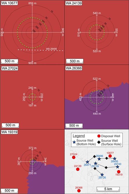
Wastewater Disposal Dense, saline wastewater generated during oil and gas activities (hydraulic fracturing and production) is disposed of in deep formations. A regional numerical density-dependent flow and transport model was used to simulate wastewater disposal in the Paddy-Cadotte Formation, which has multiple proximal disposal and water source wells. Models show that wastewater migrates further than predicted using a simple volumetric calculation, extending further along the base of the formation than the top due to variations in fluid density. Interference between disposal and source wells is observed to influence wastewater migration.
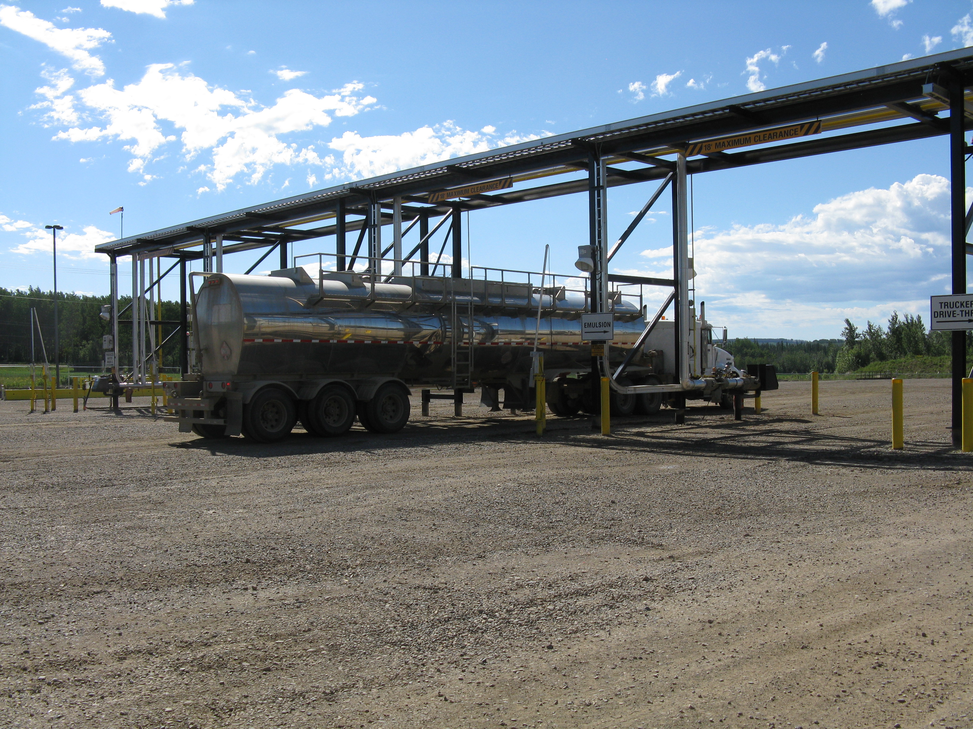
Wastewater disposal facility |
|
Figure shows Total Dissolved Solids (TDS) concentration contours in g/L for modeled disposal wells (T = 14.75 years). Furthest extent of wastewater plumes is defined by 10 g/L contour. All wells except WA 19319 show TDS concentrations of up to 250 g/L. Green circles show the extent of the wastewater plume determined using the standard industry volumetric calculation. Red and purple areas show the extent of hydrogeological units. The location of source well WA 28495 is indicated by the white dashed line close to disposal well WA 10677. Relative well locations are shown in bottom-right. Simons, M.S. (2018) Numerical Modeling of Highly Saline Wastewater Disposal in Northeast British Columbia. M.Sc. Thesis, Simon Fraser University, 163 pp. |
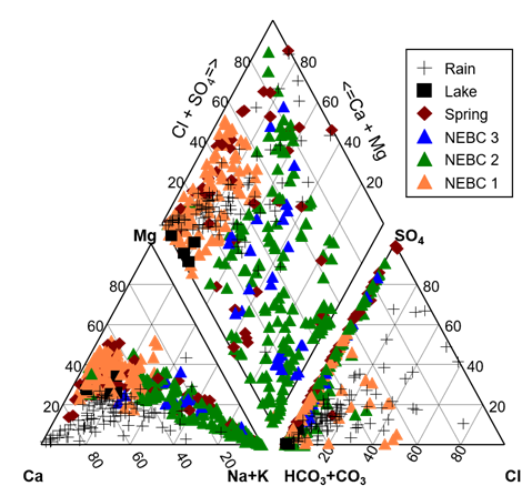
Groundwater Chemistry Groundwater, lake, spring and precipitation samples were collected throughout the Peace region (as part of the Private Wells Study) and analyzed for the chemical and isotopic composition. The lowest TDS groundwaters are the Ca-Mg-HCO3 type and are consistently completed in the Quaternary sediment sand/gravel aquifers. The more Na-rich groundwaters are predominantly sourced from wells that are completed in the bedrock aquifers. In this region, the Cretaceous bedrock formations were deposited as marine to marginal marine sediments. Marine sediments commonly impart elevated sodium content on Ca-Mg-rich fresh groundwater through cation exchange. Research on the groundwater chemistry in NEBC is ongoing. Efforts are currently focusing on establishing regional groundwater chemistry baselines for NEBC to support interpretation of the groundwater chemistry results. A regional groundwater monitoring network has also been installed, and current research aims to characterize the chemical reactions between methane gas and shallow groundwater. |
Piper Plot The groundwater samples are typically of the Ca-Mg-HCO3 to Na-HCO3 and Na-SO4-HCO3 type. The precipitation has predominantly a Ca-Mg-HCO3 type composition and very low total dissolved solids (TDS). |
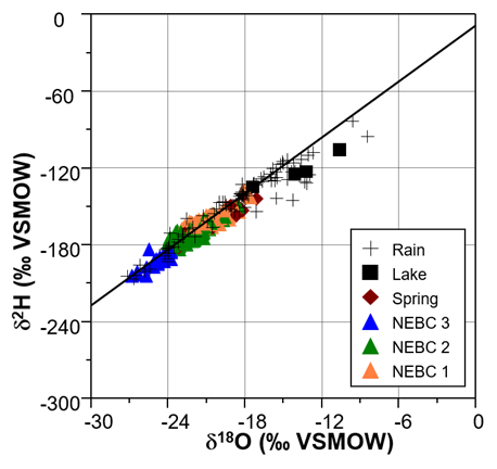
Stable Isotopes of Water The stable isotopic composition of the groundwater indicates that the majority of the groundwater was locally sourced and all of the Quaternary and some of the bedrock groundwater was recharged by the spring and/or fall precipitation. Some of the bedrock groundwater appears to either be recharged exclusively from the winter precipitation or from a colder climate. |
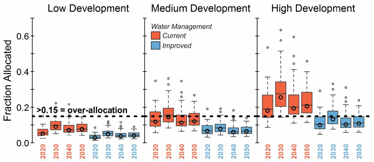
Future Water Scarcity Signficiant volumes of surface water are needed for hydraulic fracturing. Without re-cycling and re-use of fracking water, there can be signficant impacts on water sustainability. Simulated annual runoff from a naturalized hydrological model of the Blueberry headwater catchment was compared to future water demand based on different shale gas development scenarios (Pembina's BC Shale Tool). Without improved water management, allocation levels in the Blueberry headwater catchment exceeded 15% of mean annual runoff (MAR) (over-allocation) for all time periods under the high development scenario. Dierauer, J.D. (2018) Snow Drought and Streamflow Drought in Western North America in the Context of a Warming Climate. PhD Dissertation, Simon Fraser University, 188 pp. |
Blueberry headwater catchment fraction of annual runoff required to meet shale gas industry freshwater demands. Results are presented as centered 10-year averages (2020 = 2015-2024, 2030 = 2025-2034, etc.). |
|
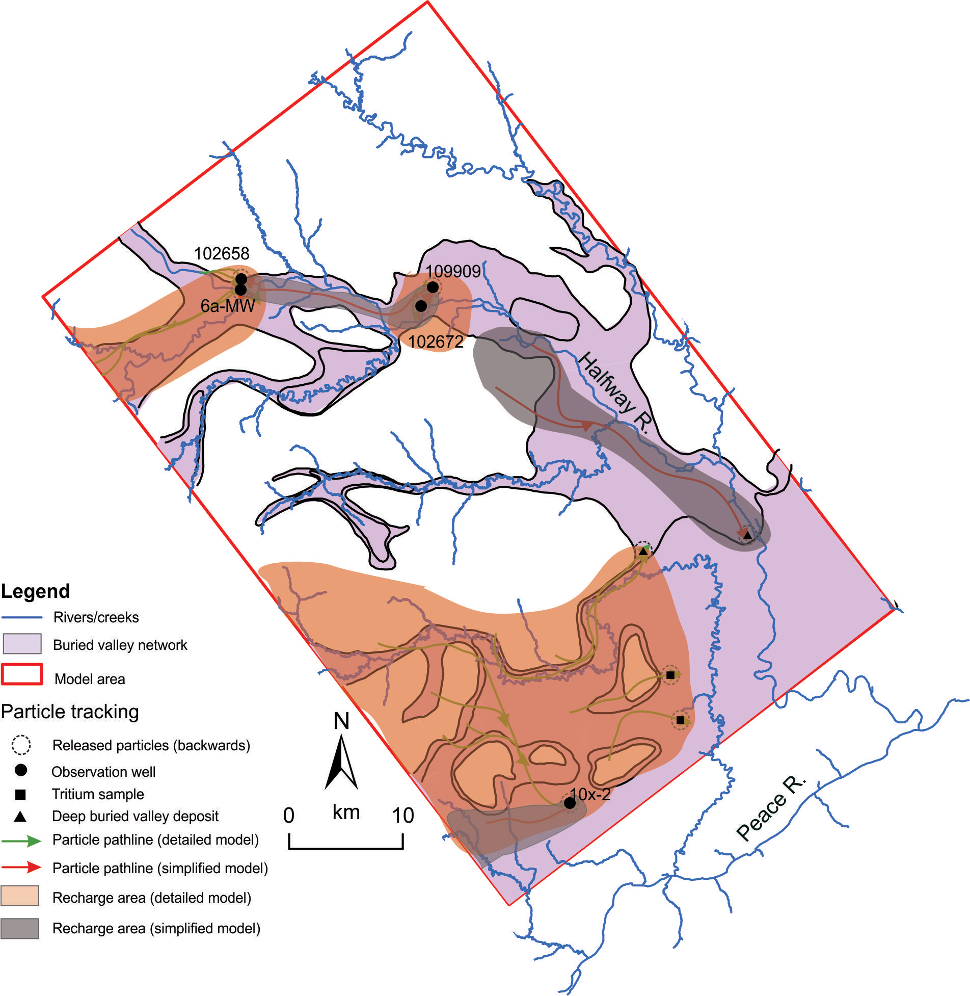
Buried Valley Aquifers: The reservoir software Petrel was used to construct the geological model of a buried valley network in NEBC by integrating interpretations from an airborne electromagnetic survey (SkyTEM) and borehole gamma-ray and lithology logs. This detailed geological model (developed using the geophysical interpretations) and a simplified geological model (deep continuous buried valley aquifer) were used to develop two numerical flow models in MODFLOW. The results for the detailed model suggest that permeable deposits exist within the buried valleys, but are not regionally connected throughout the whole network, and thus do not play a significant role in the regional groundwater flow regime. Rather, permeable deposits within the buried valleys appear to exist at smaller scales, and may offer a viable limited water source in the area. Shown on the right are 1000-year travel time pathlines for both the detailed and simplified models in the buried valley network. Differences in pathlines highlight the importance of using high-reolution geophysical data for geological models. Morgan, S.E. (2018) Investigating the Role of Buried Valley Aquifer Systems in the Regional Hydrogeology of the Central Peace Region in Northeast British Columbia. MSc Thesis, Simon Fraser University, 177 pp. |
|
|
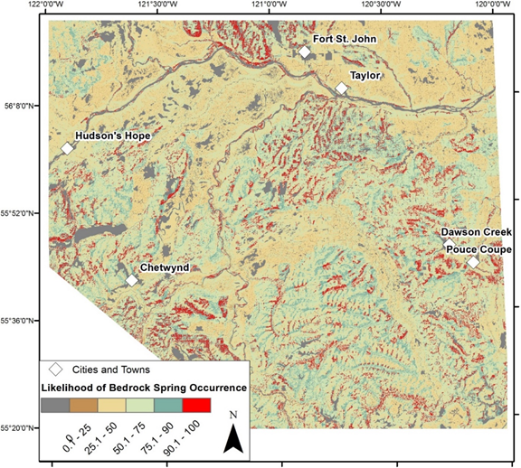
Springs:
Bystron, I. (2018) GIS-Based Analysis of Spring Occurrence and Spring Source Areas in Peace River Regional District, British Columbia. MSc Thesis, Simon Fraser University, 218 pp. |
Likelihood of Springs in Quaternary Sediments |
Likelihood of Springs in Bedrock |
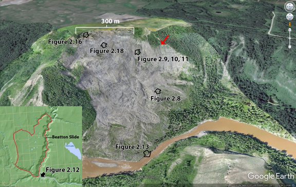
Regional Groundwater Flow and Slope Stability:Elevated pore pressures play an integral part in slope failure. This research aimed to improve our understanding of the role of regional groundwater flow regime on a large repeating slope failure along the Beatton River near Fort Saint John (the Beatton Landlide). Dandurand, R. (2018) Investigating Regional Groundwater Flow Influences on Slope Stability in Unlithified Materials. MSc Thesis, Simon Fraser University. |
The Beatton landslide reactivated on October 17, 2015. |
Conceptual Regional Groundwater Flow Model. |
| Scientific Review Panel Report:
BC Hydraulic Fracturing Scientific Review Panel (Allen, D.M., Eberhardt, E., and Bustin, A.) (2019). Scientific Review of Hydraulic Fracturing in British Columbia. Final Report to BC Minister of Energy, Mines and Petroleum Resources, February 2019, 236 pp. |
||
Review of Wastewater Regulations and Policy: A review of wastewater regulations in four shale gas basins was completed as part of a Canadian Water Network project. Full Report : Goss, G., Alessi, D., Allen, D., Gehman, J., Brisbois, J., Kletke, S., Zolfaghari Sharak, A., Notte, C.,Thompson, D.Y., Hong, K., Renan, V., Junes, C., Guedes de Araujo Neto, W.B., Prosser, C. (2015). Unconventional Wastewater Management: A Comparative Review and Analysis of Hydraulic Fracturing Wastewater Management Practices Across Four North American Basins. Final report to the Canadian Water Network, April 23, 2015, 168 pp.
Wastewater Regulation Database:link |
||
Peace Project Report: The main purpose of the Peace Project was to provide a regional overview of the Quaternary sediments and shallow bedrock geology of the region, and to locate potential aquifers, particularly within buried valleys delineated in the study area. SFU compiled the final report for this broader Geoscience BC project. Peace Project Report : Morgan, S.E. and Allen, D.M. (2018): Geoscience BC Peace Project: Final Report; Geoscience BC, Report 2018 13, 70 pp. |
||
Collaboration and Funding The project partners included the Research Institute for Humanity and Nature (Kyoto), Geoscience BC, BC Oil and Gas Commission, BC Ministry of Environment, BC Ministry of Forests, Lands and Natural Resource Operations, Encana Corp. |
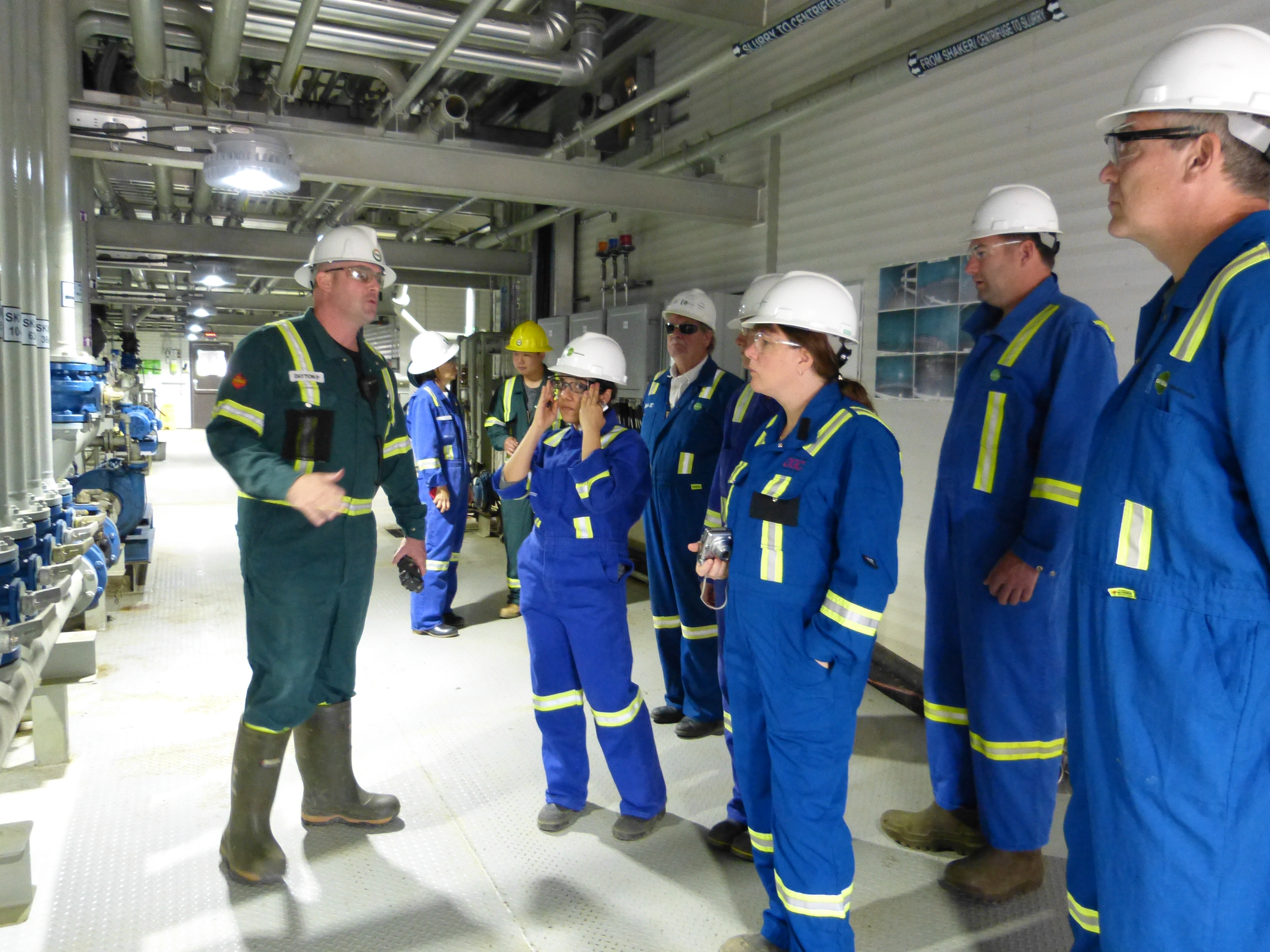
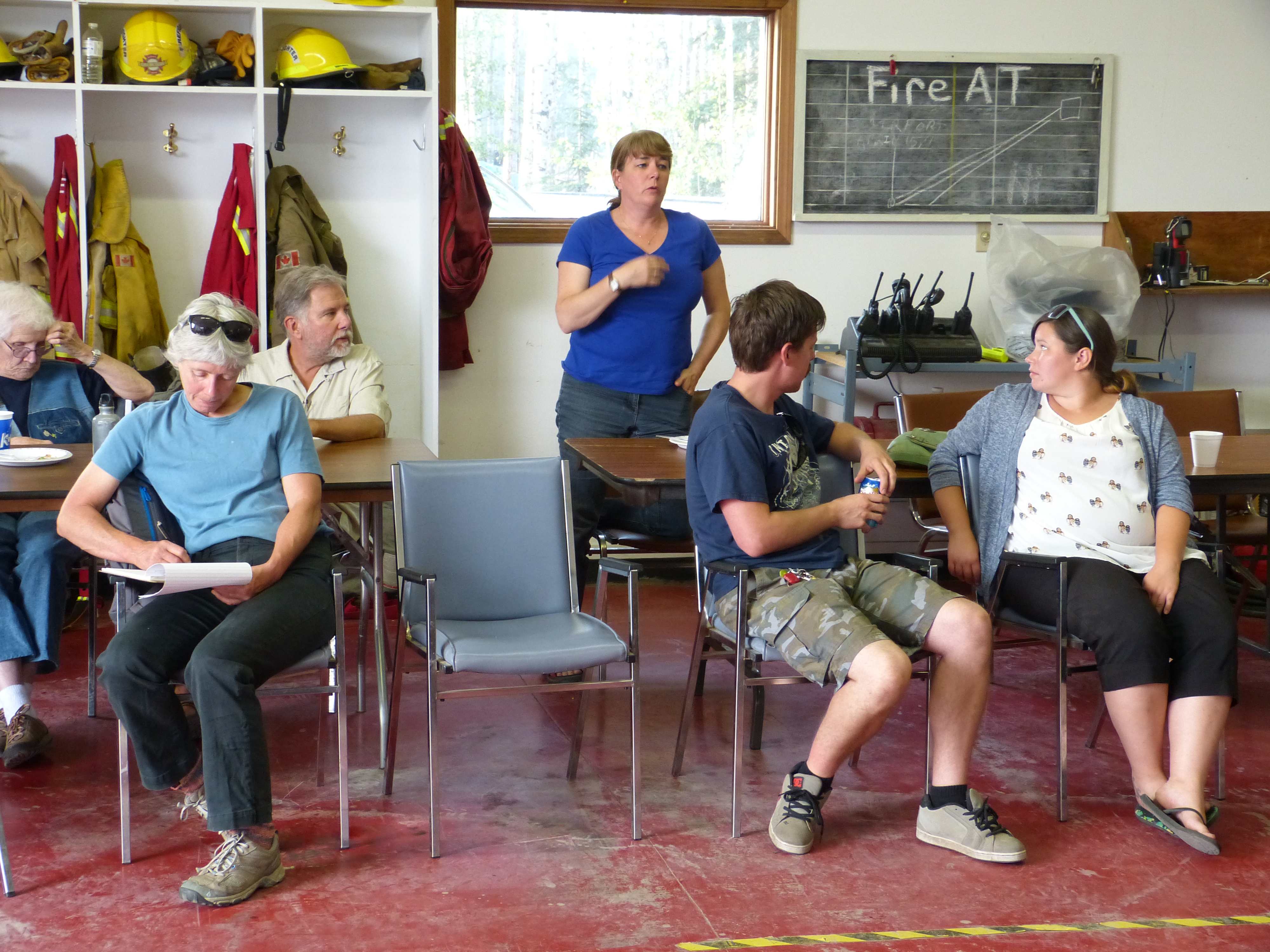
Tour of Wastewater Disposal Facility Hudson's Hope Community Meeting |
|