Shallow Groundwater Intrinsic Vulnerability Mapping |
|
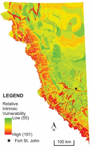 |
The DRASTIC method was used to assess the intrinsic susceptibility of shallow (< 30 m) geological materials (i.e. shallow groundwater) throughout North East BC Areas of higher vulnerability are shown in red with areas of lower vulnerability in green. Areas of higher vulnerability are predominantly present along the mountainous western edge of the region where there is high elevation bedrock. Higher vulnerability is the result of generally shallow water tables combined with high recharge rates, high permeability weathered bedrock, and limited soil cover. Other higher vulnerability areas include river valleys where the vadose zone and aquifer media have large proportions of sand and gravel. It should be noted that the results represent the relative assessment of intrinsic vulnerability, so that areas ranked low are still vulnerable to surface contamination, although they are relatively less vulnerable than other parts of the study area. The DRASTIC score within the study area ranges from 55 to 191. Final Report (Holding and Allen, 2015)GIS Data (Holding and Allen, 2015)
|