The Cascadia Subduction Zone
The Cascadia subduction zone, where the oceanic Juan de Fuca plate descends
beneath the overlying North American plate, extends 1100 km from northern California
to northern Vancouver Island. Sedimentary rocks originally deposited on the
oceanic plate are scraped off and accreted to the western edge of the continent;
the initiation of this process is indicated by the deformation front in Fig.
1. 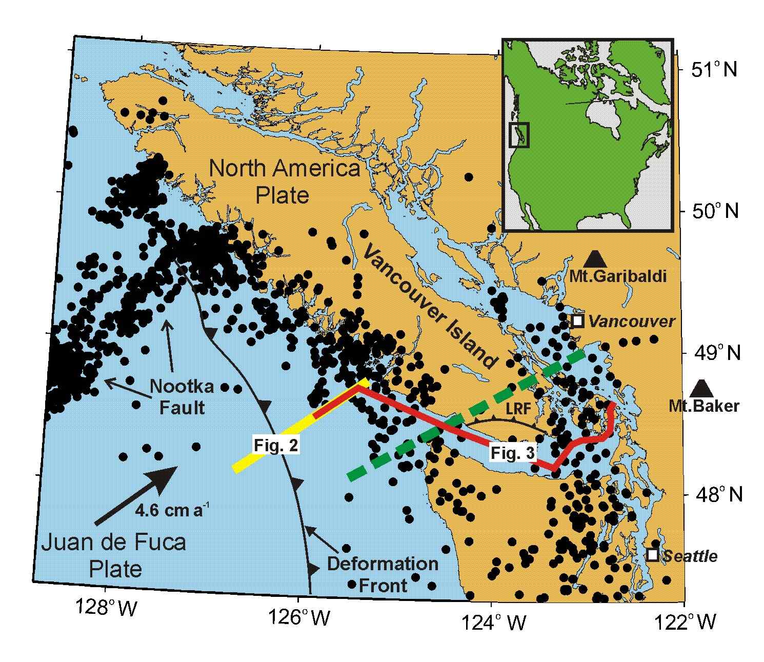
Figure 1: Map of the northern Cascadia subduction zone showing the distribution
of earthquakes in the subducting Juan de Fuca plate and the locations of seismic
cross-sections. Green dashed line shows azimuth onto which section in Fig. 3
is projected to create a representative section.
The intersection of the deformation front with the SW-trending Nootka transform
fault, which is characterized by high levels of seismicity caused by relative
motion between the Juan de Fuca plate and a small oceanic plate to the north,
marks the approximate northern limit of the subduction zone.
Earthquakes in Cascadia
Seismic hazard along the Cascadia margin is related to three different classes of earthquakes:
- Megathrust events with magnitudes that may exceed 9 occur every 200-600 years on the inter-plate boundary, where it is locked west of Vancouver Island. The last megathrust event occurred in 1700 with a magnitude estimated to be around 9.
- Inslab earthquakes, whose magnitude is usually less than 7, occur within the subducting Juan de Fuca plate at depths as great as 80 km, implying they can occur as far west as the Puget Lowland and Georgia basin. The 2001 magnitude 6.8 Nisqually earthquake that occurred near Olympia, Washington, is the most recent large inslab event.
- Crustal earthquakes, whose magnitude may exceed 7 in some cases, occur within the overriding North America plate as it deforms in response to the subduction process. The 1946 magnitude 7.3 event that occurred just west of Courtenay on Vancouver Island is the most recent large crustal event.
Numerous inslab and crustal earthquakes with magnitudes less than 4 occur each year in the Cascadia region. Beneath the western and eastern edges of Vancouver Island, earthquakes within
the oceanic plate occur in two well-defined, ~50 km wide, geographic bands that
merge further south. These earthquakes have been attributed to geochemical dehydration
reactions that generate water, reducing the normal stresses across faults and
allowing them to slip more easily.
Seismic Reflection Surveys Around Vancouver Island
West of Vancouver Island, seismic reflection surveys show that beneath the
continental shelf the top of the subducting oceanic crust lies immediately beneath
a seismic reflector that dips landward at between 12 and 25 km depth (JdF in
Fig.2). This reflector is correlated with the top of the basaltic crust in the
deep ocean basin, which there lies beneath horizontal sedimentary strata. 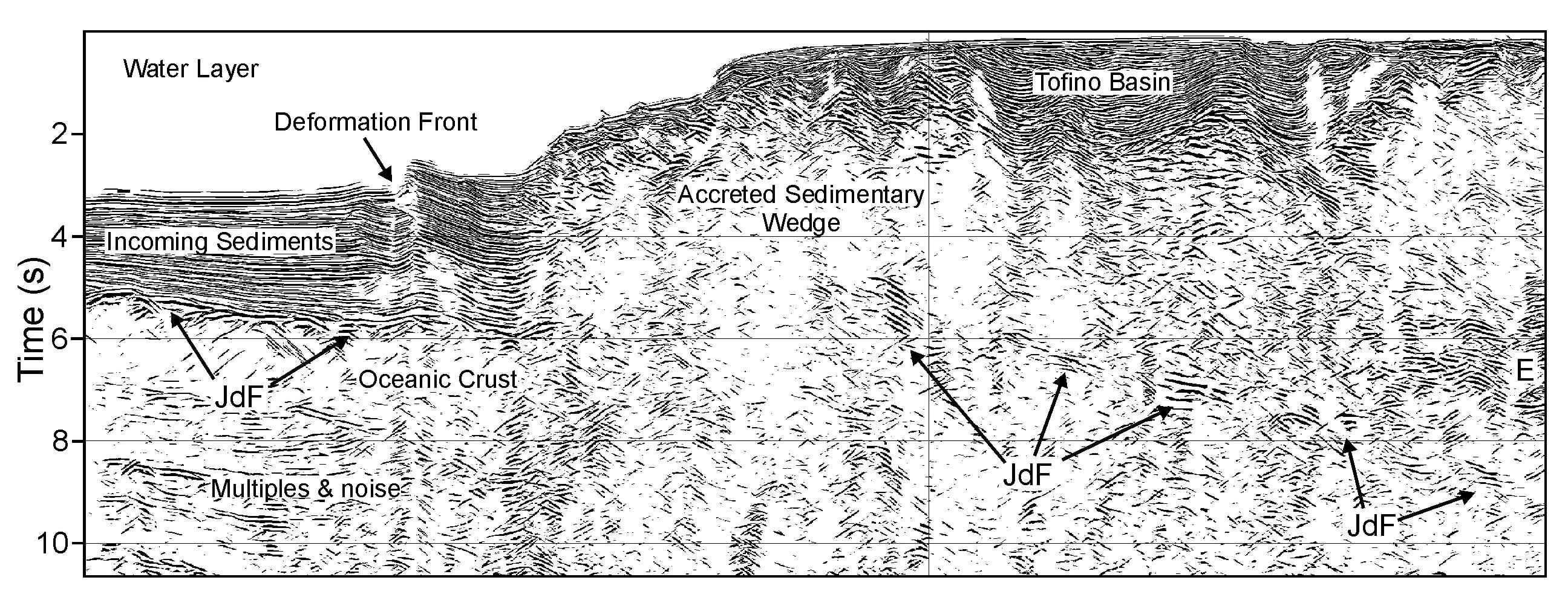
Figure 2: Migrated seismic section of line 85-01 extending
from the deep ocean basin, across the deformation front to the west coast of
Vancouver Island. JdF indicates reflections marking top of subducting plate,
and is “pushed down” beneath the low velocity water layer.
Beneath southern Vancouver Island
and its margins, seismic reflection surveys also identify two regionally extensive
structures: a thick zone of reflectors, denoted by the letter E, and a deeper,
likely individual, reflector, identified by the letter F. On a composite reflection
section across the northern Cascadia forearc (Fig. 3a), the E zone appears as
a sequence of anastomosing reflections that extends over 1.0 to 3.2 s (corresponding
to a thickness of 3-10 km), dips at 4-15o, and reaches a depth of at least 45
km east of Vancouver Island. The second reflection, F, is observed intermittently,
between ~0.5 and 2.0 s (~2-6 km) later than the deepest reflector of the E sequence.
The short duration of this reflection implies that it originates either from
a thin, <2 km thick, region, or at a single interface, and the F reflection
is interpreted to arise at the top of the subducting plate.
The E reflections dip shallowly to
the ENE at approximately 4o across southern Vancouver Island. As the reflections
reach the eastern edge of the island, their dip increases sharply to ~15o and
they continue into the uppermost mantle with this dip. In contrast, the F reflection
from the top of the subducting plate dips to the ENE at ~15o near the western
edge of Vancouver Island, and then flattens out further to the east. It is not
possible to identify unequivocally the shorter F reflection segments near the
east coast of Vancouver Island due to elevated levels of coherent noise; however,
it seems unlikely that the F reflection would crosscut the E reflections. Therefore
the F reflector must also increase in dip as it presumably merges into the deepest
of the E reflectors near the eastern edge of Vancouver Island.
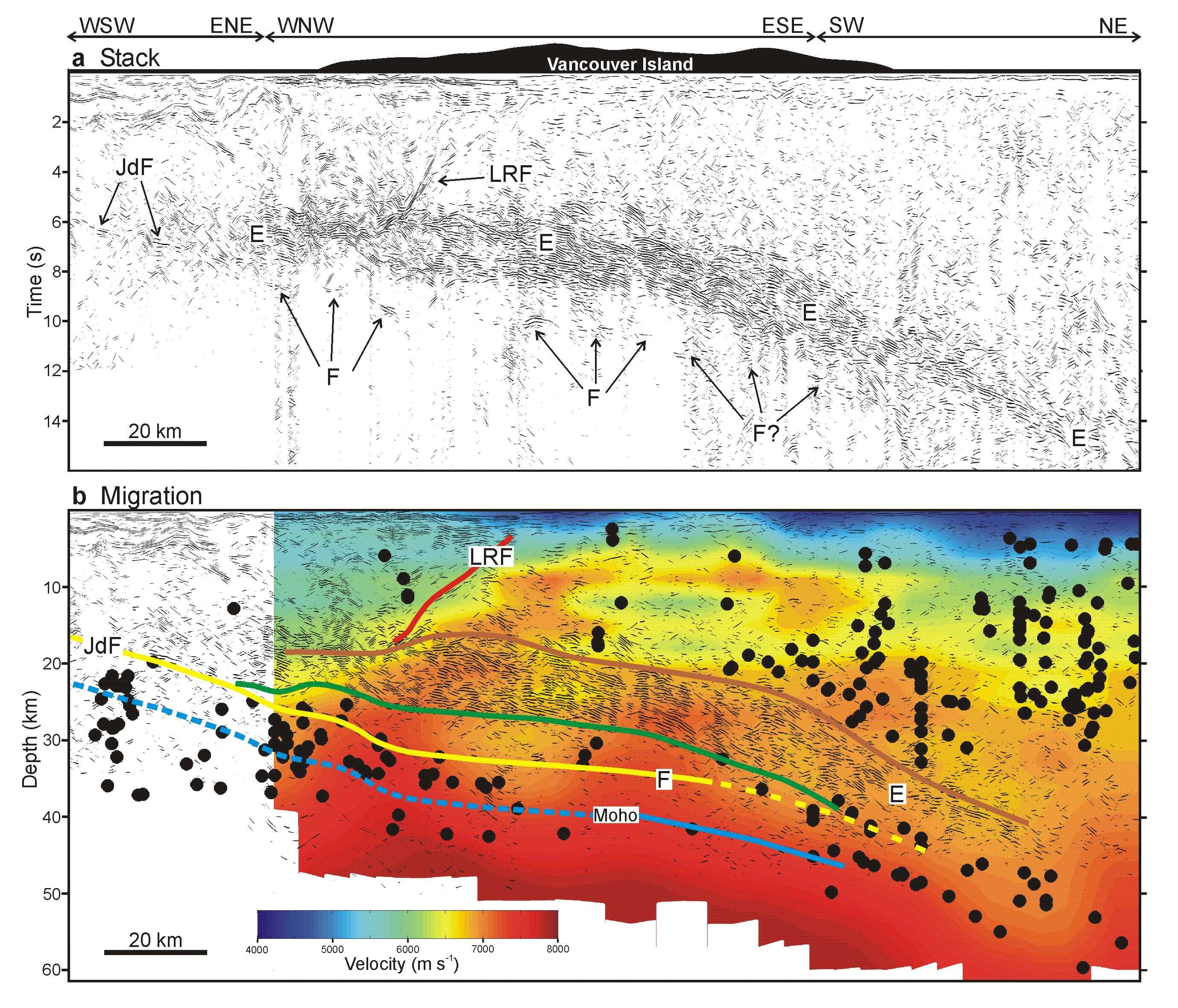
Figure 3: Composite seismic cross-section across the
Cascadia forearc near southern Vancouver Island. a, Unmigrated section showing
the reflection, JdF, from the top of the subducting Juan de Fuca plate west
of Vancouver Island, the E reflection zone, and the F reflection which marks
the top of the subducting Juan de Fuca plate further east. b, Migrated section
superimposed on a display of P wave velocities and relocated earthquakes (Ramachandran,
2001). Oceanic Moho constrained by wide-angle reflections - blue; oceanic Moho
assuming subducting crust is 6 km thick – dashed blue; top of subducting
plate - yellow; deepest E reflection - green; shallowest E reflection –
brown; Leech River fault – red. Vertical exaggeration is 1.5:1.
The Inter-plate Boundary as a Duplex
Structure
Thus identified, the E and F reflectors
define a ~110 km-wide duplex structure: the F reflection, which marks the top
of the subducting plate, is the floor thrust with a ramp-flat-ramp geometry,
and the E reflectors form the roof thrust (Fig. 4).
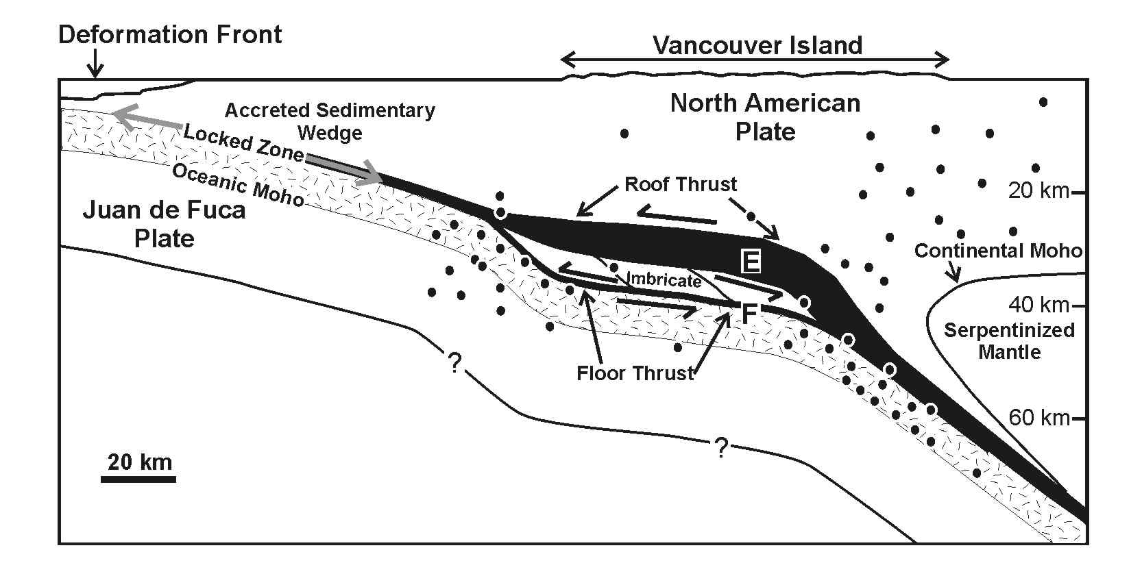
Figure 4: Schematic cross-section of the northern Cascadia
convergent margin at southern Vancouver Island. The plate boundary forms a thick
duplex structure, within which crustal rocks are imbricated. Vertical exaggeration
is 1.5:1.
Great earthquakes occur along the inter-plate boundary where it is locked, a
region that probably extends 60 km east of the deformation front. Further east,
relative motion between the two plates appears to take place through aseismic
slow-slip events that last 2-3 weeks. The E reflectors are probably one location
of the slow-slip events. Slow slip is also likely occurring along the floor
thrust, which is inferred to be the top of the subducting plate.
Origin of Inslab Seismicity
Near the west coast of Vancouver Island, numerous earthquakes, with a variety
of focal mechanisms, occur beneath the top of the subducting oceanic crust where
it dips most steeply. As the top of the plate flattens, the number of earthquakes
within the slab decreases markedly even though dehydration of the crust, which
has been linked to earthquake occurrence, should be occurring here. As indicated
in Fig. 1, there is another belt of inslab earthquakes near the east coast of
Vancouver Island, and Fig. 2b shows that this belt corresponds to the location
where the inferred dip of the subducting plate increases once more. It thus
seems likely that the two belts of seismicity in the subducting slab are linked
either to flexure or fragmentation of the oceanic plate as it subducts around
the edges of the imbricated inter-plate boundary zone. Nevertheless fluids released by dehydration reactions must also be important in stressing the downgoing plate, and the deformation of the plate beneath Vancouver Island may simply provide the additional stress that triggers seismicity here.
Summary
Subduction is usually viewed as occurring along a single, thin interface beneath
which an oceanic plate descends into the mantle, and inslab seismicity is considered
to be driven by dehydration metamorphism. In the northernmost Cascadia subduction
zone, however, the inter-plate boundary is a complex zone up to 16 km in vertical
extent, and inslab seismicity is controlled by deformation in the upper part
of the subducting plate.
References
Ramachandran, K., Velocity structure of S.W. British Columbia and N.W. Washington
from 3-D non-linear seismic tomography. Ph.D. thesis, Univ. Victoria, 198 pp.,
2001.
Further Reading
Calvert, A.J., Seismic reflection imaging of two megathrust shear zones in the
northern Cascadia subduction zone, Nature, 428, 163-167, 2004.
Dragert, H., K. Wang, and T.S. James, A silent slip event on the deeper Cascadia
subduction interface, Science, 292, 1525-1528, 2001.
Hacker, B.R., S.M. Peacock, G.A. Abers, and S.D. Holloway, Subduction factory
2. Are intermediate-depth earthquakes linked to metamorphic dehydration reactions?,
J. Geophys. Res., 108, doi:10.1029/2001JB001129, 2003.
Nedimovic, M.R., R.D. Hyndman, K. Ramachandran, and G.D. Spence, Reflection
signature of seismic and aseismic slip on the northern Cascadia subduction interface,
Nature, 424, 416-420, 2003.
Preston, L.A., K.C. Creager, R.S. Crosson, T.M. Brocher, and A.M. Tréhu,
Intraslab earthquakes: Dehydration of the Cascadia slab, Science, 302, 1197-1200,
2003.
Rogers, G. and H. Dragert, Episodic tremor and slip on the Cascadia subduction
zone: The chatter of silent slip, Science, 300, 1942-1943, 2003.