
The short historical record in the Pacific Northwest and an interval of 30 years or more between large crustal earthquakes means that there are no written records of earthquake activity for many faults that may still be active. So active faults must be identified by geological mapping or seismic surveys. For example, recent geological mapping of offsets in Quaternary strata and tsunami deposits has documented evidence of large prehistoric crustal earthquakes in the Puget Lowland. In particular, 7 m of uplift along part of the Seattle fault, a crustal fault that trends east-west through the greater Seattle area, suggests that an earthquake with magnitude greater than 7 occurred around 1100 years ago. The realization that crustal earthquakes in the Puget Lowland represent a major seismic hazard has motivated a number of recent seismic reflection studies aimed at mapping subsurface structures, and the Seattle fault zone in particular.
In 1998, the SHIPS (Seismic Hazards Investigation in Puget Sound) program acquired seismic reflection data through Puget Sound as part of a large survey aimed at mapping the subsurface architecture to depths of >30 km and relating it to known surface structures. The SHIPS program is a collaborative project between the United States Geological Survey, the Geological Survey of Canada, and a number of U.S. and Canadian universities.
Two SHIPS seismic reflection lines crossed the Seattle fault zone, which comprises a number of individual fault splays, line PS-1 in the west and line PS-2 in the east close to downtown Seattle (Fig 1). These two reflection lines permitted a detailed investigation of the near-surface (<1000 m depth) structure of the fault zone by combining the reflection images with P wave velocity models derived by inversion of first arrival traveltimes recorded in the reflection survey.
Figure 1: Seismic reflection profiles across the Seattle fault zone. The sections of the lines shown in bold allow a comparison of the eastern and western parts of the fault zone beneath Puget Sound.
Although the primary objective of a seismic reflection survey is the creation of a subsurface image showing the sedimentary stratigraphy with offsets revealing the existence of faulting, it is also possible to use the travel time of the first arrival to determine the P wave velocity variation just beneath the seafloor. Figure 2 shows the variation in first arrival times across the Seattle fault zone for a single recording channel of the towed 96-channel hydrophone streamer. Earlier first arrivals, for example in the Seattle fault zone, indicate that the rocks beneath the source and/or receiver have a higher P wave velocity, allowing the signal to travel more quickly.
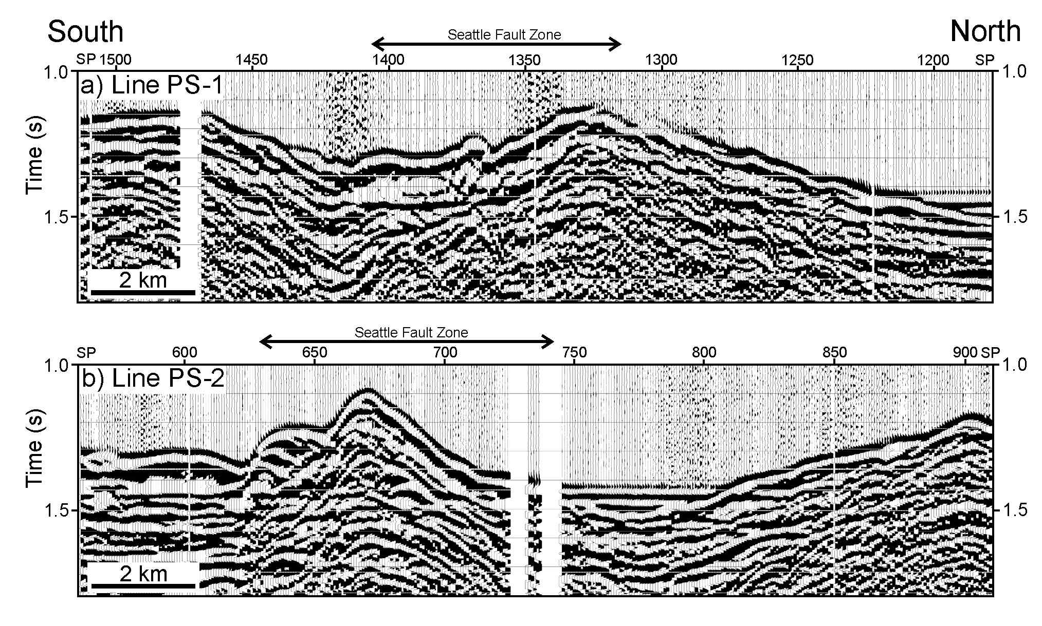
Figure 2: Seismic data from the hydrophone at 2100 m from the airgun source array, which was fired every 20 seconds. Gaps, for example between SP 700 and 750, occur where firing of the source array was stopped by biological observers due to the proximity of marine mammals.
With receivers distributed every 25 m along the towed hydrophone streamer and airgun shots fired every 50 m, a large number of first arrivals are available to constrain the subsurface velocity distribution. The velocity models are derived by a tomographic inversion method that requires a simple initial estimate of the subsurface P wave velocities (Figs. 3a and 4a), which is updated approximately 15 times during an iterative procedure to produce the final results (Figs. 3b and 4b).
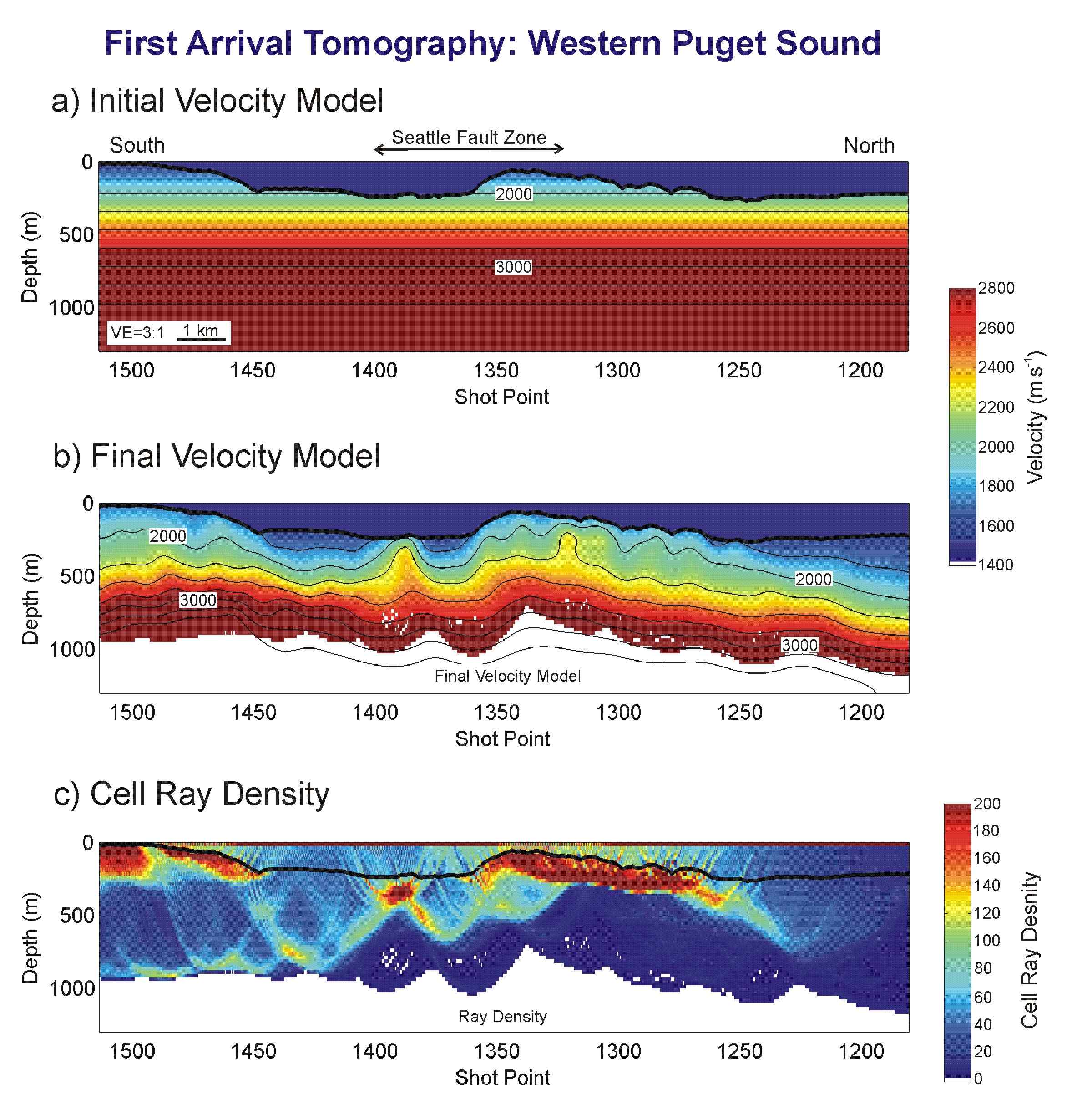
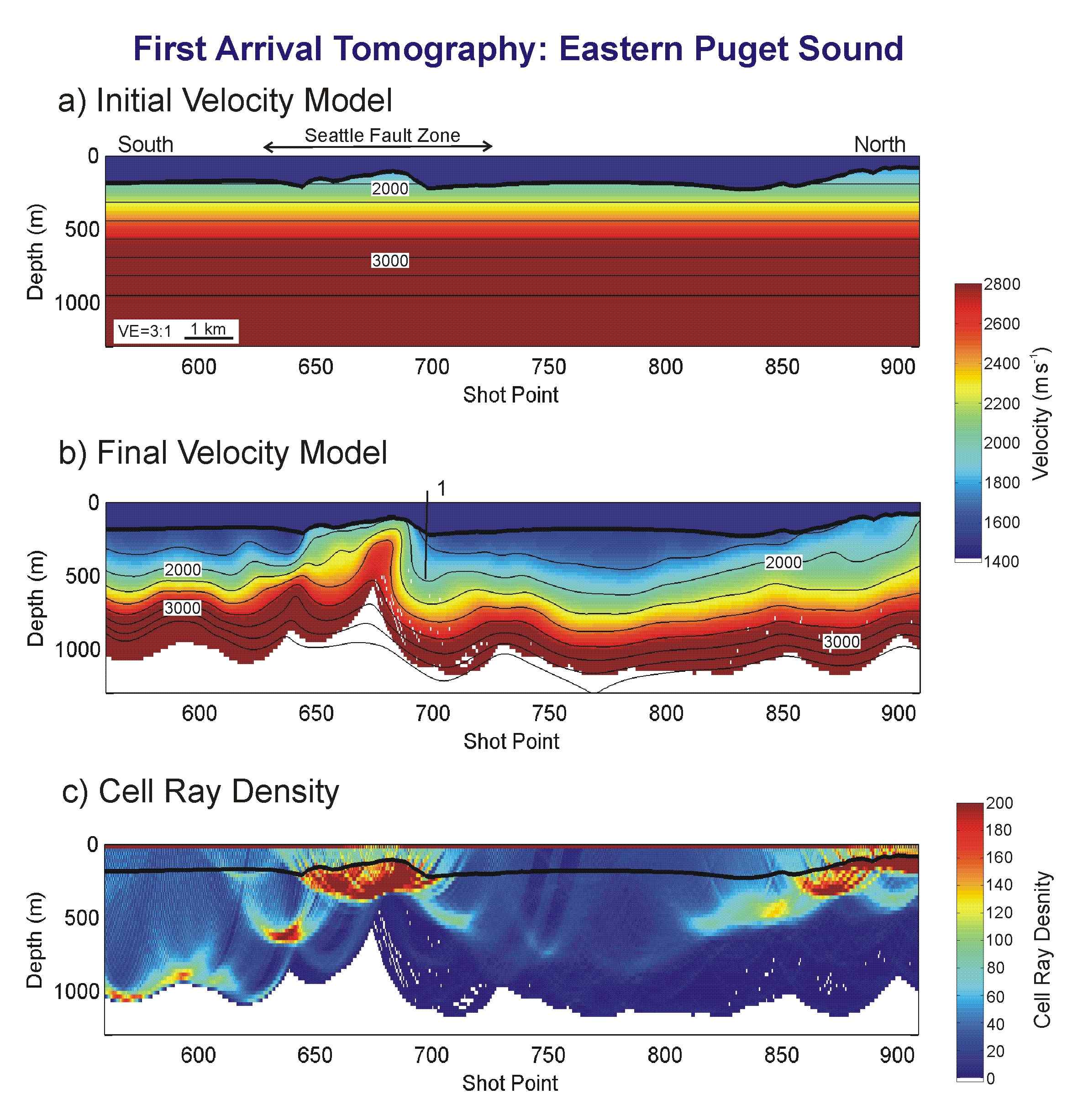
Figures 3 (left) and 4 (right): (a) Initial estimate of subsurface velocity distribution, (b) Subsurface velocity variation derived by tomographic inversion, (c) Distribution of first arrival ray paths in the final model. High ray densities indicate greater constraint of the velocity model.
Away from the Seattle fault zone, the derived sub-seafloor P wave velocity models reveal an undulating high velocity unit, in which the velocity increases with depth, that is overlain by a more uniform low velocity fill. The contact between these two units corresponds approximately to the 1800 m s-1 isovelocity contour. The tomographic inversion shows that velocities in the upper unit range from 1500-1800 m s-1, and this unit is interpreted to be unconsolidated post-glacial Quaternary deposits because these strata fill small basins in the underlying higher velocity strata. In the underlying unit, velocities increase gradually from 1800 m s-1 to 2200-2400 m s-1, and then jump more sharply to around 3000 m s-1 over a 300 m depth range. The upper part of the unit that underlies the postglacial strata, where velocities are less than 2200-2400 m s-1, is interpreted to be glacial Pleistocene deposits, and we identify the lower part, in which velocities increase to around 3000 m s-1 to be the upper part of the Tertiary sedimentary section. Unusually high velocities, greater than 3700 m s-1, occur at 800-1000 m depth at the southern end of lines PS-1 and PS-2. These velocities are interpreted to represent volcanic rocks of the Crescent Formation.
Beneath eastern Puget Sound, there is a single 2.5 km-wide region of uplifted, high-velocity, Tertiary rocks. Rocks with velocities of 2000 m s-1 are exposed at the seafloor, and the uplift zone is cored by rocks just 170 m below the seafloor with velocities as high as 2600 m s-1. The high velocity rocks within the uplifted block are restricted to a narrow zone that is 700 m wide (near SP 680 in Figure 4b). We associate these velocities with the Oligocene Blakeley Formation, which is exhumed at Alki Point 1 km east of line PS-2, because sonic logs show that most of the Blakeley Formation is characterized by velocities over 2500 m s-1. From the strong lateral change visible in the velocity model, we infer the likely existence of a steeply-dipping fault (1 in Figure 4b), along which Tertiary rocks are in contact with low-velocity Quaternary strata.
Beneath western Puget Sound, the Seattle fault zone contains two distinct zones of uplift (SP 1385-1395 and SP 1310-1360) separated by a 1000 m-wide basin filled with up to 200 m of Quaternary sediment. The northern limit of the fault zone is less clear than on line PS-2, because the velocities of the rocks thrust close to the seafloor on PS-1 are lower, 2300 m s-1, and low velocity Holocene sediments are less prevalent. We interpret the uplifted rocks with velocities of 2300 m s-1 to be Miocene Blakely Harbor Formation, which exhibits lower velocities than the Oligocene Blakeley Formation and is exposed in the fault zone on Bainbridge Island, but the presence of unusually high velocity Pleistocene rocks cannot be completely excluded. The Blakely Harbor Formation is not exposed on land near Alki Point on the east shore of Puget Sound. We infer faults near the shallow high velocity zones at SP 1330 and SP 1380, but a precise interpretation requires correlation of the velocity model with the coincident seismic reflection sections.
On seismic reflection sections, the Seattle fault zone is generally characterized by an absence of primary reflections; however, some multiple reflections and dipping coherent noise are present in the fault zone on the seismic sections displayed in Figure 5. At depth, reflections from the Tertiary and Crescent rocks cannot be followed into the fault zone, and shallow Quaternary reflections truncate against the uplifted higher velocity Tertiary rocks. On line PS-2, the Tertiary stratigraphy is folded into a syncline within the fault zone (syn in Figure 5b) near SP 660, but the absence elsewhere of primary reflections from the Tertiary stratigraphy in the fault zone is unsurprising, because steep to overturned dips have been reported in Oligocene strata at Alki Point close to line PS-2, and seismic reflection imaging of such geometries is rarely possible.
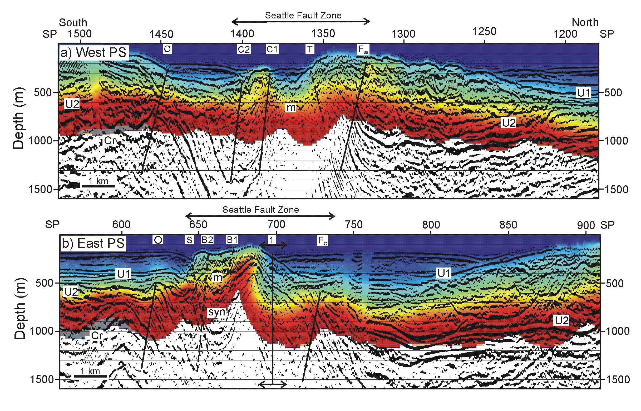
Figures 5: Superposition of velocity models on the coincident depth
migrated seismic reflection sections for: a) line PS-1, and (b) line PS-2. The
locations of the thrust faults identified in the velocity models are indicated
by the black lines; faults whose existence is uncertain are marked with dashed
lines. Low velocity Holocene and Late Pleistocene strata, which are represented
by subhorizontal reflections, fill depressions in the older Quaternary sediments,
which have a more chaotic character. In many areas, for example 1 km south of
the Seattle fault zone on line PS-2, a reflection from the Tertiary-Quaternary
angular unconformity is observed. At the south end of both lines, strong reflections
from the top of the Crescent volcanics, which are characterized by seismic velocities
greater than 3700 m s-1, occur. Colours correspond to velocity values shown
in Figure 4, with the exception of grey which indicates velocities over 3700
m s-1. B1, B2, C1, C2, O, S, T, and 1 identify faults. FW, FC, and FE identify
the western, central and eastern segments of the Frontal fault. Cr - top of
Crescent Formation; U1 - Pleistocene-Holocene/Late Pleistocene unconformity;
U2 - Tertiary-Quaternary unconformity; syn - syncline in folded Tertiary sediments;
m - multiple. The vertical exaggeration is 3:1.
The integrated interpretation of seismic reflection data and seismic velocity models shows significant along-strike differences in the number of fault splays and the degree of uplift of Tertiary rocks within the fault zone beneath Puget Sound. The most plausible interpretation of the sharp velocity contrast on line PS-2 at SP 688 is that it is associated with a north-south oriented fault that divides the Seattle fault zone into distinct segments (Fig. 6).
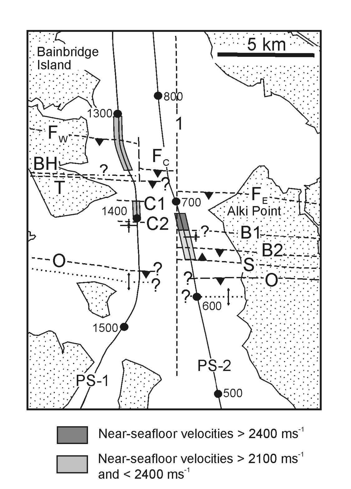
Figure 6: Detailed map modified from the interpretation of Johnson et al. (1999) showing sections of the Seattle fault zone beneath Puget Sound and the faults interpreted from SHIPS lines PS-1 and PS-2. Dashed lines indicate the position of interpreted faults. Dotted lines indicate fold axes. Question marks indicate positions where the existence of structures is uncertain. The position of the high velocity rocks identified by the tomographic inversions just beneath the seafloor is shown. Letters correspond to the fault identifications of Fig. 5, with BH being the Blakely Harbor fault.
There are also two distinct zones of uplift in the west, but only one in the east. These along-strike differences support the presence of a section boundary within the Seattle fault zone beneath Puget Sound. Although uplift in the A.D. 900 earthquake occurred on both sides of this boundary, the significant differences in the nature of the uplift we identify in our velocity models implies significant differences in fault motions shallower than 1 km depth across Puget Sound. This might be a consequence of lower magnitude earthquakes, and perhaps some M>7 events, being unable to rupture across a segment boundary. Determining the position of segment boundaries, and the depths to which they extend, is important in assessing the seismic hazard from earthquakes with various depths of rupture initiation.
Calvert, A.J., M.A. Fisher, S.Y. Johnson, and SHIPS working group, Along-strike variations in the seismic velocity structure of the Seattle Fault Zone: Evidence for fault segmentation beneath Puget Sound, J. Geophys. Res., 108, 2005, doi:10.1029/2001JB001703, 2003.
Johnson, S.Y., S.V. Dadisman, J.R.
Childs, and W.D. Stanley, Active tectonics of the Seattle fault and central
Puget Sound, Washington--Implications for earthquake hazards, Bull. Geol.
Soc. Am., 111, 1042-1053, 1999.