Archean greenstone belts host much of Earth's mineral wealth, and as such have been the focus of intense geological mapping for many years. As part of the Canadian LITHOPROBE project, and with financial and logistic support from various mining companies, it was possible to acquire a number of high-resolution seismic reflection profiles across mining camps in the Abitibi greenstone belt. These surveys have imaged well a variety of structrues internal to the greenstone belt, including volcanic stratigraphy and mafic sills. In some instances, the imaged structures are of importance to mineral exploration within a mining camp, and in others thy are not. However, at the Matagami mining camp it proved possible to image directly a volcanogenic massive sulphide (VMS) deposit beneath the seismic line. The complex geology and a wide variety of often steeply dipping structures requries that the seismic data be interpreted in 3-D using surface and borehole geological data whereever practical.
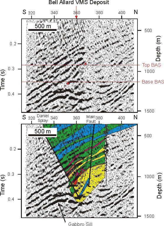
A number of VMS deposites have been developed within the Ansil mining camp, which is located in the Blake River Group of the the southern Abitibi. The sulphide deposits are found at the felsic-mafic contacts of the volcanic stratigraphy, which is underlain by the Flavrian pluton. High resolution line 21A was shot along a crooked line through the camp using a 20 m geophone and vibration point spacing. The data were carefully processed, with the most important steps being refraction statics and prestack time migration, and this allowed excellent imaging the reflective structures.
Correlation with the seismic data of the surface and subsurface geology, which was constrained by the numerous exploration boreholes, showed that there were few, if any, reflections from contacts in the volcanic stratigraphy. The strongest reflections all appear to correlate with diorite sills that extend through the volcanic stratigraphy and into the underlying granodioritic pluton. Interestingly, a short reflection segment can be identified, which is associated with the disused, and now flooded, workings of the Ansil mine; the position of the excavated ore body is shown in orange.
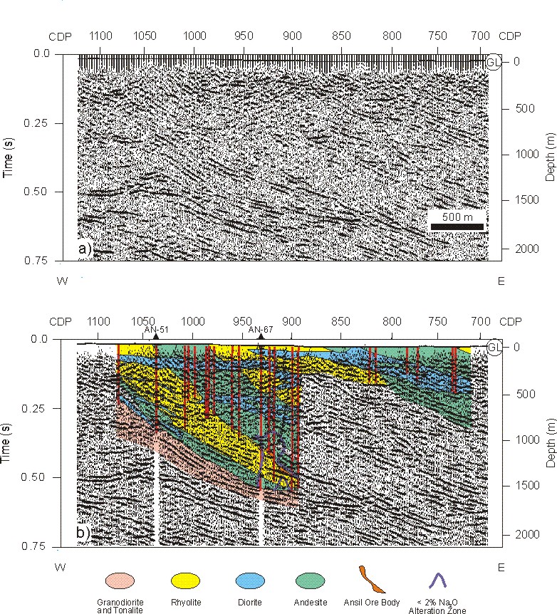
The Matagami mining camp lies in the northern part of the Abitibi greenstone belt, and a number of VMS deposits have been mined here. With financial support from Noranda, seismic line 93A was shot using a 20m shot and receiver spacing above the recently discovered Bell Allard ore body that fortuitously lies almost directly beneath the main highway to the camp. At Matagami, the ore bodies are mostly found along one felsic-mafic contact of the volcanic stratigraphy. Unlike the situation in the Ansil mining camp, the volcanic stratigraphy at Matagami is reasonabye reflective, and is imaged in the seismic section as the shallower package of dipping reflections, within which there are also some gabbro sills. The deeper, high amplitude undulating reflections are believed to be one or more mafic sills that were intersected in a nearby deep borehole. The red arrows indicate the location of the Bell Allard ore body at the top of a thick rhyolite layer that forms the deepest part of the volcanic stratigraphy.
The geometry of the ore body is well-constrained by exploration drilling and has become better defined during mining. Thus the seismic reflection appears to originate from the upper surface of the deeper part of the body, which is most pyrite-rich, and the reflection does not extend to the uppermost part of the body. There also does not seem to be a seismic signature associated with the base sulphide contact. The explanation for this may be that transitional contacts are typically found at the base of VMS deposits with the upper surface exhibiting the sharpest contrast in physical properties.
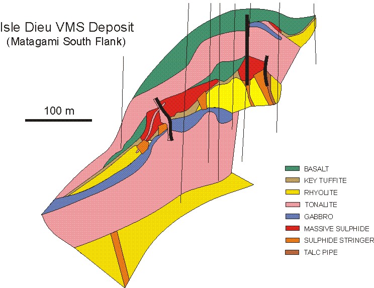
The 1-to-1 figure below shows a cross-section through the Isle Dieu volcanogenic massive sulphide deposit that has been mined in the Matagami camp. With the exception of the tonalitic intrusion, the deposit is typical of those found in the camp with the lenses or ore located along a bimodal volcanic contact, which in this case is marked by a thin exhalite horizon known as the Key Tuffite. The lenses are underlain by mineralized stringers, which likely represent the vertical pipes through which mineral-rich fluids circulated before precipitating sulphides onto an ancient seafloor in a process similar to hydrothermal vents at nid-ocean ridges today. The deposit was subsequently buried by later basaltic volcanic flows.