I. Review the video on ashfall hazards at Mt. Pinatubo.
II.Volcanic hazards at Anchorage, Alaska.
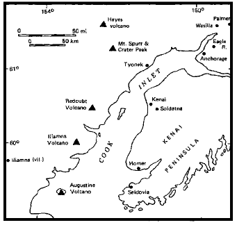
There are a large number of active volcanoes in southern Alaska and the Aleutian Islands, fed by subduction of the Pacific Plate beneath the North American continental margin. Anchorage, the largest city in Alaska (pop. 250,000) lies at the head of Cook Inlet at the eastern end of the Alaskan segment of the Pacific "ring of fire" (Fig.1). Local volcanoes have dusted the city with ash and closed the airport on two occasions in the last 15 years, and a subsidiary vent on Mt. Spurr is again threatening the city.
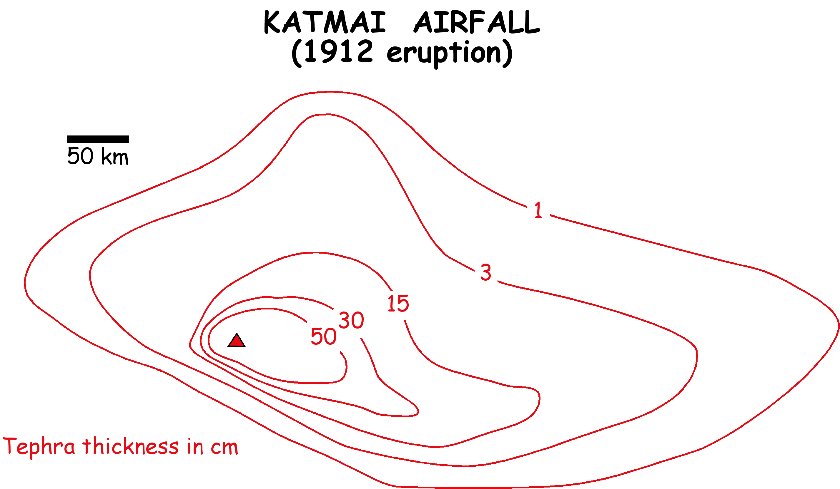
In today’s exercise you are asked to consider the hazards to the city associated with a major eruption from one of these vents. We will use the Katmai (Novarupta) eruption of 1912, the largest eruptive event on Earth in the 20th century, as a model for what might happen in an eruption near Anchorage. In the 1912 Katmai eruption (approximately x10 as large as the 1981 eruption at Mt. St. Helens in terms of volume of material expelled), most of the products formed a very thick series of pyroclastic flow deposits to the north of the vent in Katmai National Park. In the initial phase of the eruption, however, volcanic ash was deposited on Kodiak Island to the southeast of the volcano (Fig. 2).
TASKS (Work in groups of three)
1. If the Katmai eruption pattern was repeated exactly (Fig. 3) in future eruptions of Iliamna, Redoubt, Mt Spurr, and Hayes Volcanoes, how much ash would likely fall in Anchorage? (fill in the first column in Table 1)
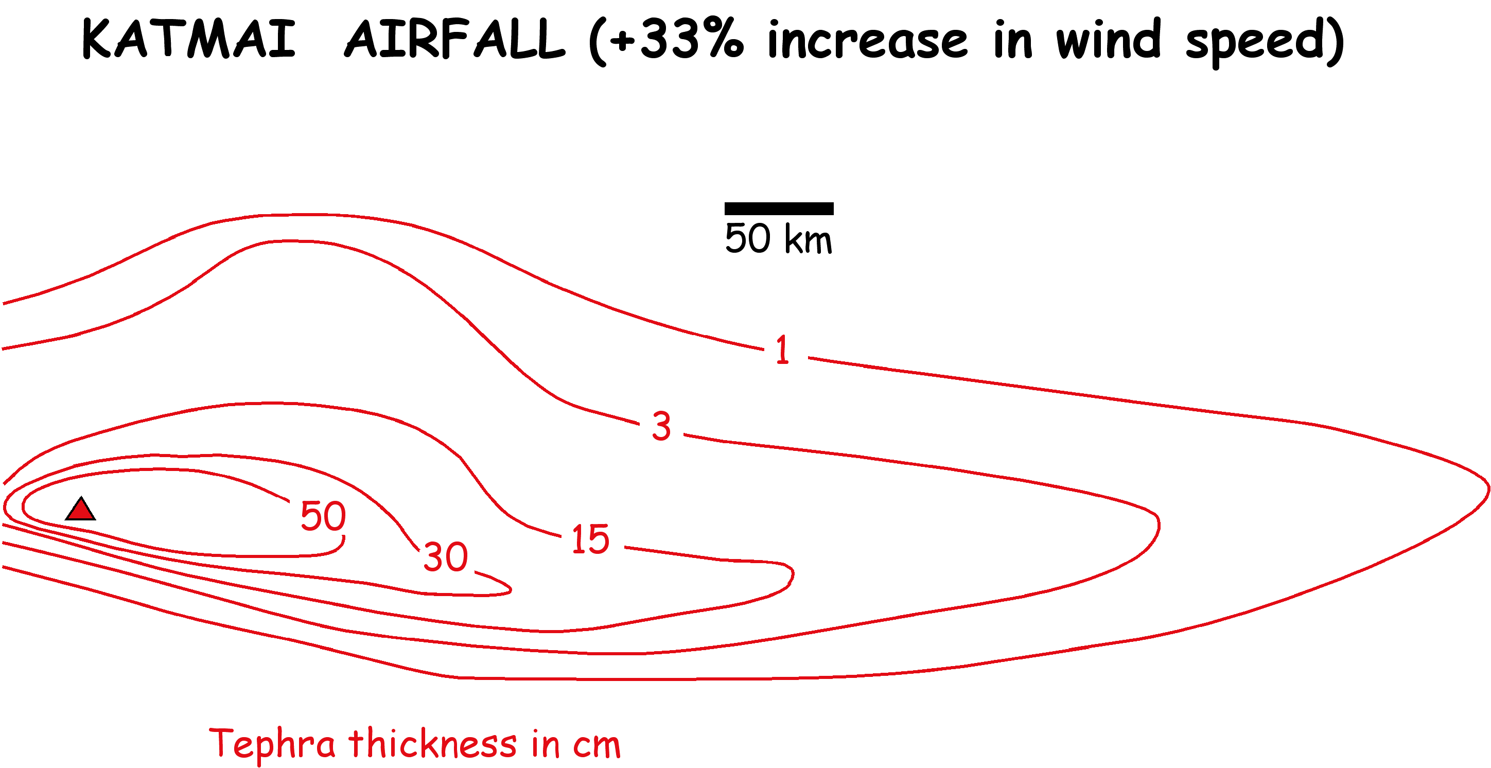
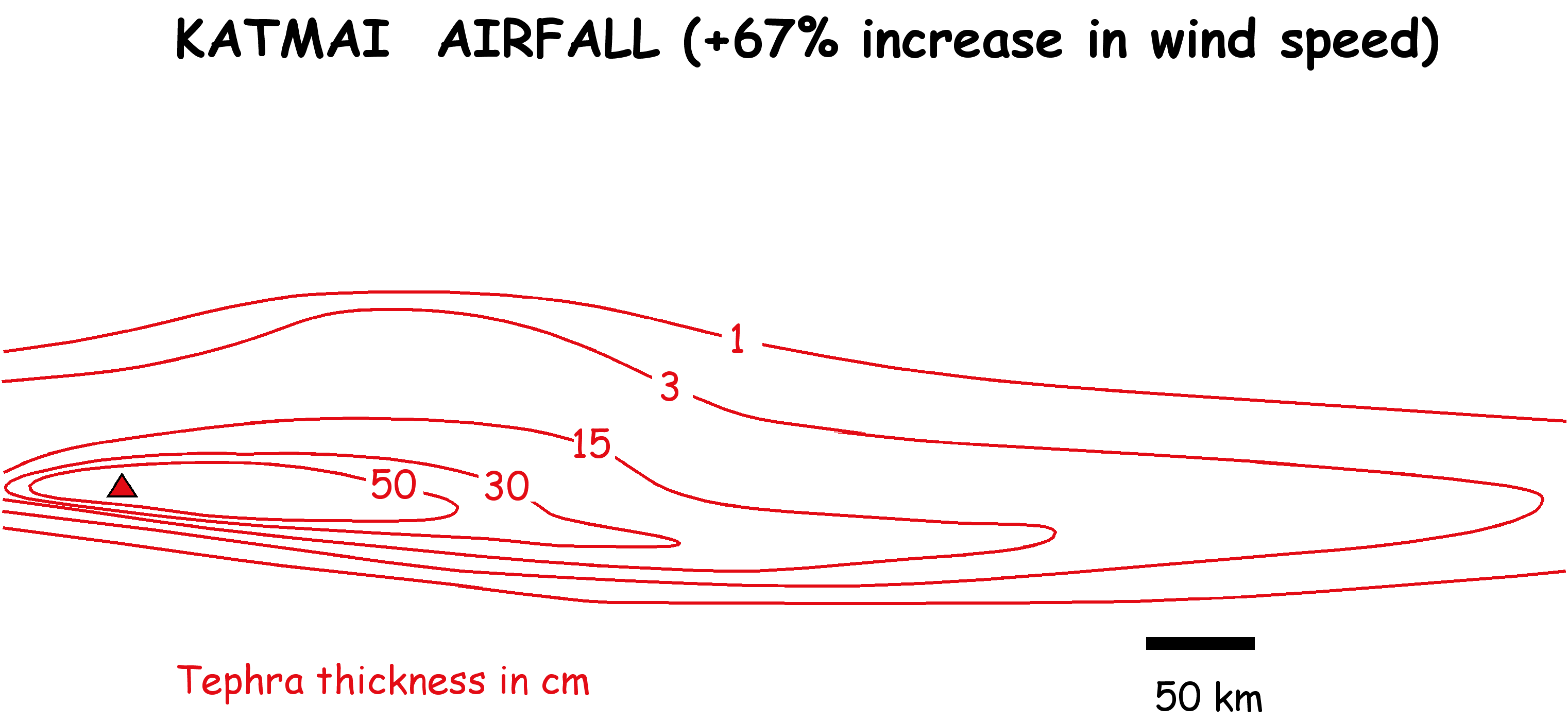
2. Katmai erupted in early summer, when upper-air wind speeds around the Gulf of Alaska are relatively low. What would be the likely ashfall in Anchorage if upper air-wind speeds were (a) 33% greater (see Fig. 4), or (b) 67% greater than at the time of the 1912 eruption (see Fig. 5)? (fill in columns 2 & 3 in Table 1).
Table 1. Predicted ashfall in Anchorage (cm)
| Source volcano |
Katmai
|
Katmai
+33%
|
Katmai
+67%
|
| Iliamna |
|
|
|
| Redoubt |
|
|
|
| Mt.Spurr |
|
|
|
| Hayes |
|
|
|
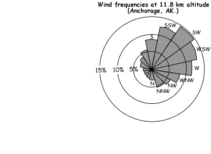
3. Wind direction, of course, can also vary. You are provided with an upper-air wind rose for Anchorage that shows the probability of winds from a given compass direction. Use this to determine the probability of receiving a significant (>1 cm) fall of ash in Anchorage from an eruption equivalent to the 1912 event at Katmai these same volcanoes (Table 2)
Table 2. Probability of a significant (>1 cm) ashfall in Anchorage
Upper-atmosphere wind direction
| Source |
SSE
|
S
|
SSW
|
SW
|
WSW
|
W
|
WNW
|
NW
|
Sum
|
| Iliamna |
|
|
|
|
|
|
|
|
|
| Redoubt |
|
|
|
|
|
|
|
|
|
| Mt. Spurr |
|
|
|
|
|
|
|
|
|
| Hayes |
|
|
|
|
|
|
|
|
|
4. Iliamna has erupted 14 times in the last 240 years. The eruptions are consequently relatively small, and there is likely a low probability of an ash fall from this volcano reaching Anchorage, but we will assume that that the 1912 Katmai scenario applies. What is the annual probability of receiving an ash fall >1cm? (Fill in Table 3).
5. Redoubt Volcano has erupted 7 times in the last 3500 years. What then is the annual probability of receiving an ash fall >1 cm? (assume that the 1912 Katmai scenario applies).
6. Mt. Spurr has erupted 24 times in the last 3500 years. What then is the annual probability of receiving an ash fall >1 cm? (assume that the 1912 Katmai scenario applies).
7. Hayes Volcano has erupted once in the last 3500 years. What then is the annual probability of receiving an ash fall >1 cm? (assume that the 1912 Katmai scenario applies).
8. What is the combined probability from all four sources?
Table 3. Annual probability of a significant (<1 cm) ashfall in Anchorage
| Source volcano |
Sum
(Table 2)
|
Ann. eruption
probability
|
Ann. ashfall
probability
|
Ashfall
RI
|
| Iliamna |
|
|
|
|
| Redoubt |
|
|
|
|
| Mt.Spurr |
|
|
|
|
| Hayes |
|
|
|
|
| Total hazard |
|
|
|
|
9. On the basis of this table, which is the highest-risk volcano?
DISCUSSION
What precautions (if any) should an individual (or family) living in Anchorage take given this level of hazard from ashfall?
What precautions (if any) should the city take?
Based on this example, can you suggest what constitutes a 'threshold' hazard, below which an individual, family or local government need take no precautions? Does this apply in Vancouver, for example, with respect to the hazard of ashfall from Mt. Baker? Note that there have been no ashfalls in the Vancouver area in the Holocene [the last 10 000 years] from eruptions at Mt. Baker, and only one from any Cascade volcano [Mt. Mazama = Crater Lake, Oregon].
|