1993 TOP SECRET CODE PAGE
Surveying plays a very important part
in archaeological excavation.
"Surveying" means measuring the site,
all of its bumps and dips and
the way the land or features on the land
are laid out.
The first survey is known as a "contour
survey" and this tells us very
basic information about the site, like
where it is highest, where it is lowest
and where there are hills or creeks.
After this survey is done, archaeologists
do other surveys called "leveling".
Leveling surveys are made before, during
and after the dig.
They tell us about the differences (variations)
in height in
major deposits or features.
"Spot heights" are also recorded.
For instance, the height of a mound,
or depth of a house pole pit were things
that were measured
for their spot heights at DhRl 16.
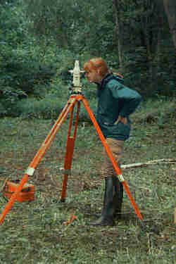
Pieces of equipment used in archaeological
survey are measuring tape
and meter sticks. Very often we
use a special instrument that
looks like a telescope, it is called a
theodolite.
You might have seen a theodolite being
used at the side
of the road by construction workers -
this is the same instrument that we use.
A theodolite can tell us exactly
how high or how low the land is
in any part of the site.
Here is a picture of a theodolite in use:
 Another way of measuring the land is using
the GPS system.
This way of measuring the site,
is done by a satellite!!
The measurements are very good and accurate.
Because of this, many archaeologists like
GPS.
Unfortunately, it is very expensive, and
as you have probably already learned, archaeology costs a lot of money
- sometimes we have to think of ways to save money.
If we can measure a site using a theodolite,
it is much cheaper.
Measuring a site and its features is important
so you can make maps
and understand the land better.
Sometimes, surveying can be difficult though,
just one mistake can make a whole set
of measurements wrong!
Zoweee, that's pretty heavy
duty stuff!!
TAKE
ME
Another way of measuring the land is using
the GPS system.
This way of measuring the site,
is done by a satellite!!
The measurements are very good and accurate.
Because of this, many archaeologists like
GPS.
Unfortunately, it is very expensive, and
as you have probably already learned, archaeology costs a lot of money
- sometimes we have to think of ways to save money.
If we can measure a site using a theodolite,
it is much cheaper.
Measuring a site and its features is important
so you can make maps
and understand the land better.
Sometimes, surveying can be difficult though,
just one mistake can make a whole set
of measurements wrong!
Zoweee, that's pretty heavy
duty stuff!!
TAKE
ME TO 1993!