The analysis of our results to
meet our objectives and the purpose of our project was performed by comparing
the areal coverages of each vegetation class to the old map. It consists
of two parts: the comparison of the different classification techniques
and the comparison between the classified Ikonos imagery and the old map.
The evaluation of the MAUP was accomplished in the same manner.
Comparison of the different classification techniques
The basis of this analysis consists of a visual interpretation of the
classified imagery and of the comparison of the areal coverage of each
class. Therefore we calculated the areas in Idirsi and performed
further computations in MS Excel.
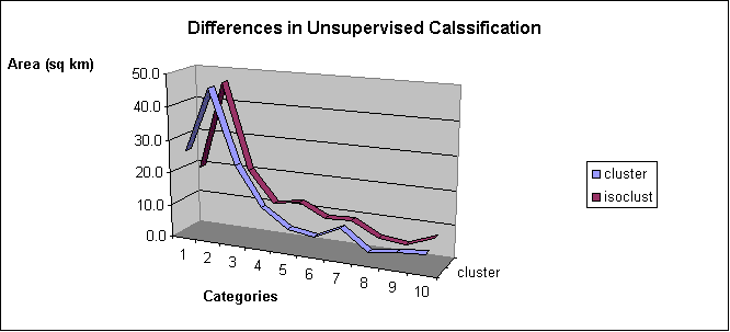
Unsupervised classification
The visual interpretation of the results for
the two unsupervised procedures (see Map Gallery) showed a decrease in
Salix Equisetum,... (light green and an increase of the undefinable vegetation
class (green) ) in the Isoclust classification. But both techniques
show the same general trends in the areal coverage of each class (see chart
below). The main differences in comparing the Cluster to the
Isoclust classification in percentual coverage is as follows:
Cluster Isoclust
salix-equisetum, equisetum (salix) (category 1)
18.70% 13.66%
undefinable (vegetation) (category 2)
4.62% 8.66%
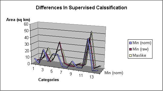
Supervised Classification
The visual interpretation of the three unsupervised
results (see Map Gallery) showed different distributions of the plant assemblages.
The Minimum Distance to Means [normalized distances] classifier was very
insensitive in the separation of the Aquatic class (category 1) and the
cloud shadows (category 14), whereas the other two classifiers (Minimum
Distance to Means [raw distances] classifier and Maximum Likelihood classifier
[ML]) rather assigned aquatic vegetation to the cloud shadow class.
Another major difference can be detected in the sixth category (Alnus Salix),
where the MDM-raw classifier showed the highest aggregation. Another striking
feature is the high proportion of the Decadent Populus assemblage in the
MDM-norm classification (category 9). The MDM-norm seems to tend
to support plant assemblages which have a minor share in the MDM-raw and
ML classification whereas, the other seemed to support frequently appearing
classes. Nevertheless, a general trend in all three classifications cannot
be denied (see chart below). The most striking changes of percentual
areal coverage are as follows:
MDM-norm MDM-raw
ML
Aquatic (cat 1)
5.30% 2.50%
2.90%
Alnus Salix (cat 6)
12.88% 24.51%
15.53%
Decadent Populus (cat 9)
7.92% 0.68%
0.72%
Cloud Shadow (cat 14)
1.91% 4.72%
2.82%
Comparison Between the Classified Ikonos Imagery and the Old Map
The comparison of the classified and clipped Ikonos images could provide
a reference for selecting the proper classification methods. After employing
five classification methods, we get five classification images. Since it
is difficult to tell the difference exactly by visually interpreting the
images, we calculated the areas and created the charts below.
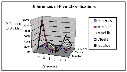
The following conclusions can be drawn: The MDM-norm classifier
shows the greatest difference to the old map in the second category.
The MDM-raw and the Isoclust classifiers result in a generally smaller
differnce. No matter which classification is used, the differences
of the five major plant assemblages between 1979 and 2000 cannot be neglected;
especially for Alnus-salix and Salix-equisetum. Another striking
feature is the classification of water areas depending on the classification
method. As water is different perceived by humans and computers,
a classification without ground truthing will result in errors. Our
final choice, the MDM-norm and the Isoclust classifiers represent the biggest
and smallest difference from the old map; the former the biggest and the
latter the smallest.
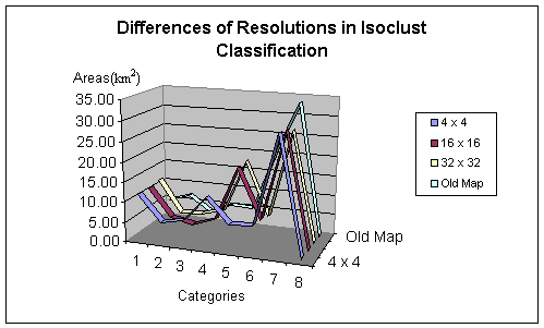
Evaluation of the Modifiable Areal Unit Problem Analysis of Different
Resolutions
 This
part is accomplished for the trimmed images, since they also allow us to
compare the different results to the vegetation map. We evaluate
the effect of different resolutions (see Map Gallery) based on the classification
results of the MDM-norm and the Isoclust classifier. Accordingly
to the previous method we calculated the areas of every category in the
different images and created the charts below.
This
part is accomplished for the trimmed images, since they also allow us to
compare the different results to the vegetation map. We evaluate
the effect of different resolutions (see Map Gallery) based on the classification
results of the MDM-norm and the Isoclust classifier. Accordingly
to the previous method we calculated the areas of every category in the
different images and created the charts below.
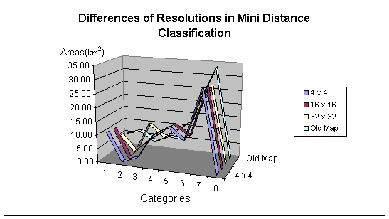
The following conclusions can be drawn: Firstly a change in the total
area of the map was observed. This is due to the aggregation of pixels
(the leftover of each column and row is lost). Not only is data
averaged, but it is also lost completely. The larger the resolution,
the bigger the change in total area. Changing resolutions also cause
different classification results. For the plant categories 2, 3 and
4, the areas are quite different regarding resolution and classification
techniques. Most striking is the areal change of the Salix plant
assemblage.