Photos were taken by L. Lesack unless otherwise noted. These photos cannot be reproduced for publication or commercial purposes, without the explicit permission of the photo contributor.
| THE MACKENZIE RIVER DELTA - A complex Arctic ecosystem: | |||
|---|---|---|---|
| Diversity of lakes and channels spanning an area equivalent to 1/3rd the size of Switerland. | 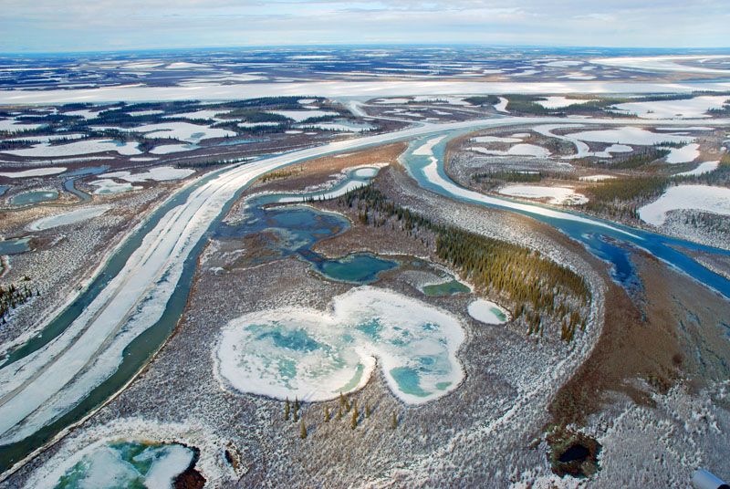 |
Effects of river ice and 24 hour per day solar irradiance, on delta lakes. |  |
| WHERE WE WORK: | |||
| Mackenzie Delta location within the circumpolar arctic. |  |
Locations of Tsiigetchic, Fort McPherson, Inuvik, Aklavik, and Tuktoyaktuk. Area can be viewed in Google Earth. |  |
| Mackenzie Delta overlay on south-western BC - a comparison for people in Vancouver who think the Fraser is a big river. |  |
Tuktoyaktuk - as viewed from the bridge of the Nahidik. The town is keeping a close watch on rising sea level. |  |
| Tsiigehtchic - where Arctic Red River flows into the Mackenzie River. |  |
Fort McPherson - on the bank of the Peel River with the Richardson Mountains bordering the western side of the Mackenzie Delta in the background. |  |
| Inuvik - East Channel of Mackenzie Delta in foreground. | 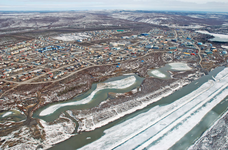 |
Aklavik - Aklavik Channel wrapping around the town. |  |
| Welcome to Inuvik! Photo by Catherine Febria. |  |
The Inuvik Research Centre - Headquarters of the Aurora Research Institute and laboratory facilities supporting scientific research in the western Canadian arctic. Photo by Catherine Febria. |  |
| HOW WE GET AROUND: | |||
| Sampling via small boat. |  |
Sampling via helicopter - Essential for access to sites in a delta containing 45,000 lakes! Photo by Catherine Febria. |  |
| Small aircraft equipped for air-borne remote sensing - SFU owned Cessna 185 with turbo-charger for high-altitude flights. |  |
Feeling light-headed at ~12,000 ft. |  |
| Sampling via big boat. |  |
The Nahidik - A shallow draft ship capable of navigating major channels of Mackenzie Delta and serving as a mobile platform for experimental work in aquatic science. |  |
| THINGS WE DO: | |||
| Our river-ice hydraulics expert. |  |
More river ice experts. |  |
| Ice jam in Middle Channel of the Mackenzie Delta. |  |
Ice jam in East Channel of the Mackenzie Delta. |  |
| Water samples from the Mackenzie River and Peel River upstream of the delta. Photo by Faye Hicks. |  |
Refueling at Swimming Point in the outer Mackenzie Delta. Photo by Faye Hicks. |  |
| Beaufort Sea in May? - Actually, not the Beaufort but a rather large area of Mackenzie River overspill onto land-fast ice extending into the Beaufort. |  |
Several upwelling holes, in the land-fast ice, through which Mackenzie river water flows out over top of the ice. |  |
| A series of ice cracks and holes in the land-fast ice, with Mackenzie river water upwelling though and flowing out over top of the ice. |  |
Taking a water sample from an upwelling hole - Note, we drilled holes to confirm ice thickness was ~ 2 m (and in photo to the left) before attempting to do this. Photo by Steve Solomon. |  |
| A small strudel hole, with active "whirlpool" flow down through the ice - River water overspilling onto land-fast ice may drain down through holes and cracks in the ice, after the ice releases and floats up. |  |
Strudel hole in offshore ice - Flow here is strong, causing a drain-hole whirlpool. |  |
| Measuring the depth of ice and water through an inactive strudel hole. |  |
GPS navigation is essential for finding locations and deployed field equipment. |  |
| The Caribou Hills - bordering the eastern edge of the Mackenzie Delta. |  |
Muskoxen in the Caribou Hills. |  |
| Preparing GPS ground control at the Invuik Airport for calibrating air-borne lidar measurements of high-resolution delta topography. |  |
Blue polygons show coverage of lidar during low-water and sequential aerial imagery during rising-water - outer delta coverage includes the Kendall Island Bird sanctuary and proposed oil/gas extraction fields. |  |
| Drilling an ice hole for under-ice water sampling and current velocity measurements. |  |
Using a remote underwater video camera to check on the condition of a current meter installed beneath ~ 2 m of ice. |  |
| Real-time measurements of under-ice current velocity transmitted via satellite to Bedford Institute of Oceanography. |  |
Spot measurements of under-ice current velocity are taken a numerous locations in the river channel network of the delta to facilitate hydraulic modeling of channel discharges. |  |
| "Holographic-looking" ice hole down into "black ice" of a Mackenzie Delta channel. |  |
Gas-stripping of a water sample while in the field for measurement of pCO2. Photo by Jolie Gareis. |  |
| Measuring content of CO2 and CH4 in water samples via gas chromatography at the Inuvik Research Centre. |  |
Spectrophotometer used for measuring water optical properties and for colorimetric analyses of water nutrient content. |  |
| Mackenzie Delta lakes during summer. A long-term program of limnological research has been on-going since 1991. |  |
Towing a canoe - used for access to lakes with no direct channel connection to the river. Photo by Catherine Febria. |  |
| Filtering water samples and splitting into sub-samples for various analyses to follow. |  |
Taking a moment to "cool off" on deck during the 28 degree weather at Tuktoyaktuk! |  |
Return to IPY-SCARF page: HERE - Return to Delta Limnology page: HERE