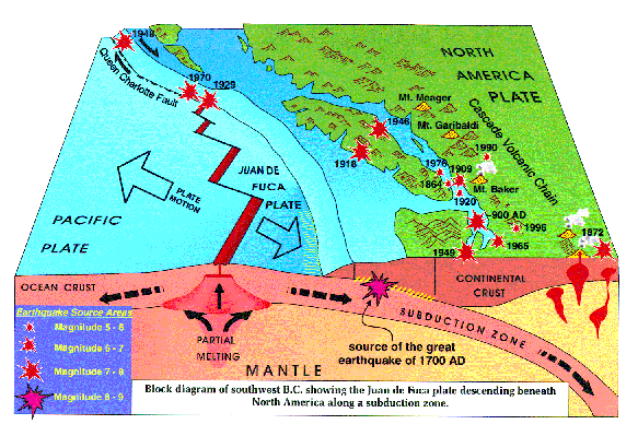
The Cascadia subduction zone
This block diagram shows subduction of the oceanic Juan de Fuca plate beneath continental crust of North America. Geophysical evidence
demonstrates that the subduction zone is locked and accumulating strain that will be released in future great (magnitude 8 or larger) earthquakes.
There is abundant geological evidence in tidal marshes along the Pacific coast from Vancouver Island to northern California for repeated,
historically unprecedented great earthquakes in the recent past. The diagram also shows the locations of large (magnitude 6-7+), historic,
crustal and subcrustal earthquakes in southern British Columbia and northern Washington.
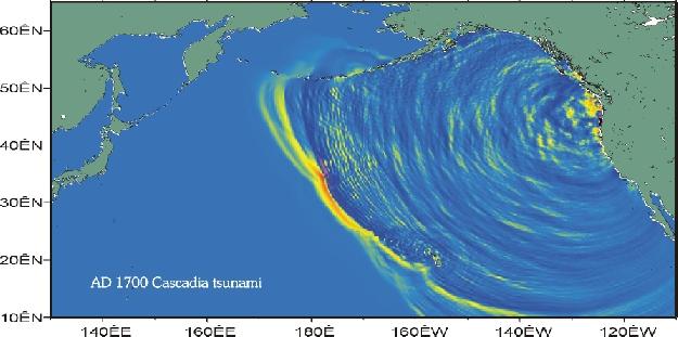
1700
Cascadia tsunami
(courtesy of Kenji Satake).
This computer-generated
image shows the tsunami produced by the great Cascadia earthquake of January 26,
1700, six hours after initiation. The tsunami moved across the Pacific Ocean
and produced destructive waves up to several metres high along a 1000-km length
of the coast of Honshu in Japan. Much larger waves struck the west coast of North
America less than 30 minutes after the shaking stopped. Deposits of this tsunami
are preserved in tidal marshes and low-elevation coastal lakes on the Pacific
coast. Their distribution provides information on the wave run-up that can be
expected from future Cascadia tsunamis.
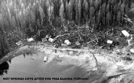
Hot
Springs Cove after the 1964 Alaska tsunami
The tsunami caused $10
million damage (1964 dollars) to coastal communities on Vancouver Island. Port
Alberni was hardest hit, but Hot
Springs Cove, Tofino, Ucluelet, and Zeballos
also suffered damage. The photo shows the remnants of the village of Hot Springs
Cove shortly
after the tsunami struck in the early morning hours of March
28, 1964. Geological traces of much larger tsunamis produced by earthquakes at
the Cascadia subduction zone are preserved in tidal marshes and low-lying
coastal lakes on western Vancouver Island. Study of these
deposits provides
insights into tsunami hazards and risk on the British Columbia coast. (photo by
Charles Ford).
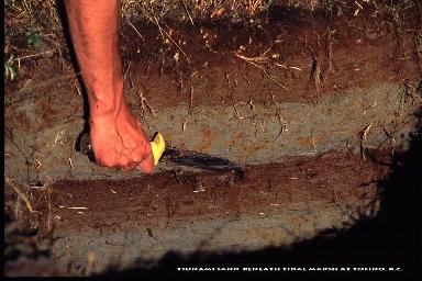
Tsunami
sand beneath tidal marsh at Tofino, BC
A layer of clean sand is
sharply bounded by peat and mud in a pit dug at a marsh just east of Tofino on
the west coast of Vancouver Island. The sand occurs as a sheet that thins
and fines landward and contains marine microfossils. It was deposited by
a landward surge of seawater at the time of the last great earthquake at the Cascadia
subduction zone in A.D. 1700. (photo by John Clague).