 1. Conceptual Outline
1. Conceptual Outline
Introduction
As a new comer in Canada from a country which is experiencing
water shortage, abundant and refreshing cold water at the turn of a tap is
really enjoyable and appreciative. Clean and safe water is a big gift from
nature and keeping it clean is our responsibility. Of course BC is a water rich state.
However, after the trip to Capilano Lake, I started to wonder about the question
regarding water safety. This is because I saw that the city is developed until just under the
neck of the watershed, and I saw some spots, which were clean-cut trees to
build roads and buildings. There were many areas under construction near
watershed. Expanding
city seems to be inevitable in the Lower Main Land due to population growth (click
the picture to enlarge). However,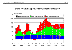 it
is well known that because water is dynamic even from the surface to
underground, water used upstream can and do affect its quality downstream.
it
is well known that because water is dynamic even from the surface to
underground, water used upstream can and do affect its quality downstream.
Since my tap water comes from Capilano
reservoir 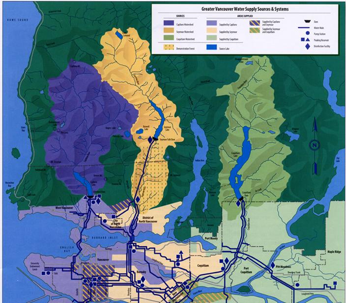 (click
the picture to enlarge),
I started to think
about how this area has been developing and what makes the water in danger
in terms of the city expansion. It is the purpose of this project to create a
model using IDRISI to establish a safe-water-distance zone for the Capilano
watershed area. Buffer zones can be made according to the land use, contour
lines and stream lines, and the area in water danger will be represented
visually.
(click
the picture to enlarge),
I started to think
about how this area has been developing and what makes the water in danger
in terms of the city expansion. It is the purpose of this project to create a
model using IDRISI to establish a safe-water-distance zone for the Capilano
watershed area. Buffer zones can be made according to the land use, contour
lines and stream lines, and the area in water danger will be represented
visually.
Overview the studied area
Capilano reservoir itself supplies 40 percent of the region's drinking water. Historically, it is the first regional water system completed on March 26, 1889. The Greater Vancouver Water District (GVWD) manages three watersheds - Capilano, Seymour and Coquitlam - for the purpose of supplying drinking water to 1.8 million residents of Greater Vancouver Regional District (GVRD).
The Capilano reservoir, which
is one of three water supply reservoirs serving the Greater Vancouver Regional
District (GVRD), has a history of periodically failing to meet the Canadian
Drinking Water Guidelines for turbidity. As part of the development of a
long-term watershed management plan for the Capilano, since March 2001, the
GVRD has been upgrading seepage control in the area east of the Cleveland
Dam—referred to as the east abutment (click
the picture to enlarge).
 This project involved excavating approximately 300,000 cubic metres of soil
to form a stable slope, constructing a concrete wall to cut off seepage, and
above this wall, extending the existing seepage control blanket by 260 metres.
This project involved excavating approximately 300,000 cubic metres of soil
to form a stable slope, constructing a concrete wall to cut off seepage, and
above this wall, extending the existing seepage control blanket by 260 metres.
In this matter, my concern is the impacts of human activities in this area. To improve the accessibility to this area, buildings, roads, clear cut tree, constructions all these kinds of development are too close to watershed and make the watershed unsafe.
