|
|
|
[ Home ]
|
[ Data Acquisition ]
|
[ Project Design ]
|
[ Spatial Analysis ]
|
[ Problems ]
|
|
Spatial Analysis
I will be using two types of MCE to find the most suitable area. The first one is using the overlay module with Boolean images and the second one is using the Weighted Linear Combination (Fuzzy module). MCE: Boolean Operations The first step in analyzing the problem is to come up with a set of criteria for all the different factors. The criteria which I have used to determine the most suitable area are listed below:
Click here to view the macro modelers. Boolean images with buffer zones
The final result must meet all these criteria in order to be considered as the most suitable place to live in Vancouver. MCE: Weighted Linear Combination (WLC) The first step in analyzing the problem with the WLC is to calculate the distance from each pixel to each of the 8 criteria for evaluation. To do this, the DISTANCE module needs to be run on each layer. Here is a sample of the results:
The advantages of the WLC method is the ability to give different relative weights to each of the 9 factors in the aggregation process. Factor weights, sometimes called tradeoff weights, are assigned to each factor. They indicate a factor's importance relative to all other factors and they control how factors will trade off or compensate for each other.In the case of WLC, where factors fully trade off, factors with high suitability in a given location can compensate for other foctors with low suitability in the same location. After this is done, simply go through the Decision Wizard in GIS Analysis to create the objective of finding the most suitable place based on the 9 factors.
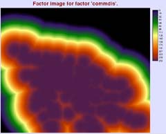
From weights are weighted heavier on all the outdoor factors, such as parkfuzz, commfuzz, bikefuzz, stopfuzz, and stationfuzz. These weights are more in favorite of some one who loves outdoor activities, such as shopping, biking, and relies on public transit. Here are the fuzzy images for the 9 factors.
|