| Methodology: |
|
Multi-Criteria Evaluation (MCE) is an efficient and
helpful analysis tool to evaluate certain problems such as suitability
to place certain features in certain places. MCE works by having two types
of criteria: constraints and factors. Constraints are expressed in
Boolean map form where a limit is set to remove areas that are
not of interest. For example, a value of 1 is assigned to areas that
are in INCLUDED in consideration for analysis and a value of 0 is
given to areas that will be EXCLUDED from consideration for analysis.
Factors are the type of criteria that will help define to what degree
each factor included in consideration will be suitable compared to others.
Factors: |
| Landuse: | The New police station should be further away from excluded landuse types (landuse with value=0) but within the considered landuse types (landuse with value=1) |
| Average Income: | The new police station should be suitable to locate in areas of low income because crime and low income have always been considered tied with one another. |
| Unemployment Rate: | The new station should be in areas where unemployment rates are high because high crimes rates are also associated with high unemployment rates. |
| Total Number of Crimes (Surrey Districts): Example |
The new station should be in areas where total number of crimes is high. |
| Police Station: | The new station should not be near the existing police station in Surrey. |
| Schools: | The new station should be away from schools because it would cause panics and would be disrupting for people attending surrounding schools. |
| Bus Routes: | The new station should not be close to existing bus routes as it will be inconvenient for police to navigate through traffic, and it would be inconvenient for locals that are commuting by bus. |
| Water: | The new station should be far away from waterways because the fear of natural factors such as flooding and other issues. |
| Skytrain Station: | The new station should not be near existing skytrain station, because there will be a large influx of people moving in and out of the skytrain station, although there are only a few skytrain stations in the city of Surrey. |
| Factors to Standardize | Membership Function Shape | Membership Function Type | Min | Max | Control Points | Fuzzy Raster |
| avginc_rcl1 | Monotonically decreasing | Sigmoidal | 0 | 32767 | c=100 d=32767 | avginc_fuzzy |
| unemp_rcl2 | Monotonically decreasing | Sigmoidal | 0 | 67 | c=0 d=67 | unemp_fuzzy |
| crime_rcl | Monotonically increasing | Sigmoidal | 0 | 5 | a=0 b=5 | crimefuzzy |
| police_dist | Monotonically increasing | Sigmoidal | 0 | 16187.4 | a=100 b=16187 | policefuzzy |
| school_dist | Monotonically increasing | Sigmoidal | 0 | 5448.32 | a=100 b=3500 | schoolfuzzy |
| bus_dist | Monotonically increasing | Sigmoidal | 0 | 6440 | a=100 b=4500 | busfuzzy |
| water_dist | Monotonically increasing | Sigmoidal | 0 | 11453.1 | a=100 b=3000 | waterfuzzy |
| skystation_dist | Monotonically increasing | Sigmoidal | 0 | 23265.5 | a=100 b=20000 | skystationfuzzy |
 |
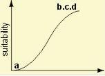
This is a visual example of a sigmoidal curve. A Sigmoidal Membership function was used to show and explain concepts such as, the further away the new police station is from the existing police station, bus routes, skytrain station, or schools the more suitable. Also to show that it is more suitable to locate close to areas with higher total crimes or high unemployment rates. |
| 0 | 0 | 2 |
| 255 | 3 | 3 |
| 150 | 4 | 4 |
| 0 | 5 | 5 |
| 200 | 6 | 6 |
| 0 | 7 | 8 |
| 100 | 9 | 9 |
| 150 | 10 | 10 |
| 0 | 11 | 12 |
| -9999 | ||
| Landuse Code | Landuse Name | Reason to Locate in these Area | Values given in Reclass |
| 3 | Open and Undeveloped | best to locate new police station in open areas | 255 |
| 4 | Residential - Single Family | medium range suitability to locate in these areas | 150 |
| 6 | Residential - Rural | more Suitable to build in areas with rural residential | 200 |
| 9 | Residential - Townhouse and Low-rise Apartments | less suitable to locate in these areas | 100 |
| 10 | Residential - High-rise Apartments | medium range suitability to locate in these areas | 150 |
|
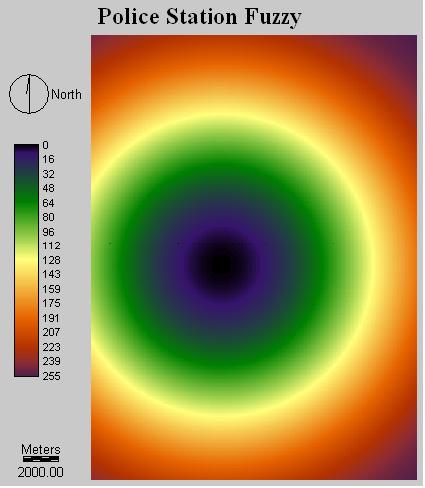
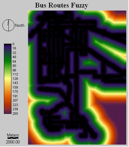
The following images are example of some of the map results after fuzzy sets was applied to them to standardize them to value of 0-255: | |


|
|
 |
 |
 |
Peter Chan . Copyright © 2006.