Introduction
ß
|
The Global Energy and Water Cycle Experiment (GEWEX) is a program initiated by the World Climate
Research Program (WCRP) to observe, understand, and model the hydrological cycle and energy fluxes
in the atmosphere, at land surface, and in the upper oceans. GEWEX is an integrated program of research,
observations, scientific activities and the application of remote sensing technology to model regional
hydrological processes and water resources. In conjunction with the GEWEX Continental-scale International
Project (GCIP) in the Mississippi Basin, the Canadian contribution to GEWEX, the Mackenzie GEWEX Study
(MAGS), conducted a series of large-scale hydrological studies within the Mackenzie River Basin. The
central objective of MAGS is to develop a research methodology to model water and energy fluxes for a
characteristic Canadian Arctic Basin (Pietroniro et al, 1996a).

The Liard River Valley is a large wetland-dominated sub-basin of the Mackenzie River Basin. This
sub-basin has been selected as a research watershed representative of the wetland-dominated zone of
discontinuous permafrost. The sub-basin can be further partitioned into six catchment areas that include:
the Martin River, the Blackstone River, the Birch River, the Poplar River, the Jean Marie River, and the
Scotty Creek catchment. The detailed analysis of flow pathways through wetland areas requires large-scale
analysis of representative catchment regions. Consequently, project research initiates with the large-scale
analysis of Scotty Creek, and then proceeds to the extrapolation of information for subsequent application
to the analysis of the entire Lower Liard River Valley.
Research interests function to determine the unique combination of hydrological variables such as
rainfall, soil moisture, snow cover, lake, ice, and glacier evaporation, and hydrologically significant
terrain mapping to facilitate an increased understanding and prediction of energy flux (Quinton et al, 2000).
Glaciers helped to form the wetlands in Canada 9,000 to 12,000 years ago. Large wetlands formed when
glaciers dammed rivers, scoured valleys, and reworked floodplains. Countless smaller wetlands were created
as a result of large blocks of ice left behind by receding glaciers that formed pits and depressions in the
land surface. Numerous depressions later filled with water due to poor drainage or intersection with the
water table. Of recent interest in society is the relationship between the health of wetland regions and
the human value obtained from them. Wetlands are considered one of the most productive ecosystems on earth.
Such regions regulate water levels within watersheds, improve water quality, reduce flood and storm damages,
provide important fish and wildlife habitat, as well as support hunting, fishing, and other recreational
activities. Wetlands are important features in watershed management (Goldberg, 2000).
Regions inundated with water almost year round are termed wetlands. Ecosystems that develop on these
lands subsequently are dominated by the presence of water excesses. Wetlands are found within flat
vegetated areas, landscape depressions, as well as between water and dry land proximal to the edges of
streams, rivers, lakes, and coastlines. The recurrent or prolonged presence of water at or near surface
is the dominant factor determining the nature of soil development and the types of plant and animal
communities living in the soil and on its surface (NWWG, 1988). Classification of wetlands environments
can then be undertaken by the presence of unique vegetation termed hydrophytes that are adapted to life
in soils that form under flooded or saturated conditions.

Wetlands occupy extensive regions of Canada. A significant proportion of these wetlands have been
anthropogenically altered, some exploited for peat others drained for agricultural or forestry
applications. The extent of wetlands in Canada is not known with any degree of accuracy. The distribution
of wetlands in Canada is determined primarily by the climate and by the morphology of the land surface,
alone or in combination. Climate functions to determine the volume of water a region receives through
precipitation. Incoming energy plays an important role in the fate of the precipitated water lower
incoming radiation rates generate a lower evapotransporation rate, consequently allowing water to pool
on the surface.
Land morphology acts to influence the distribution of surplus water and the ultimate location of
wetlands. Large, flat plains of fine-textured soils have the intrinsic property of poor internal and
external drainage rates that result in surface water surplus. Within undulating surface topography
wetlands may form in small, poorly drained depressions. In cool areas with low rainfall, wetlands usually
develop only in depressions where water collects from adjacent slopes or from the upstream part of a
catchment basin. Water may also be added to the system through groundwater discharge. In addition to
climate and the surface configuration of the land, the physical and mineralogical characteristics of
surface materials also influence wetland development. The texture of the surface material determines the
porosity of the soil and therefore the proportion of water that can percolate into the soil (NWWG, 1988).
The dependence for wetlands on climate and landforms is clearly illustrated by the distribution of
wetlands in Canada (Figure 2). The greatest concentration of wetlands occurs in a belt across northern
Ontario, central Manitoba and Saskatchewan, northern Alberta and the Mackenzie Valley (NWWG, 1988). The
Mackenzie Valley is characterized by extreme cold in the winter months and cool temperatures throughout
the summer months. In combination relatively low mean annual precipitation the region is hence favorable
for wetland development.
The Mackenzie Basin is regulated by numerous diverse cold-region phenomena such as snow and ice
processes, permafrost, Arctic clouds, and radiation interactions. These phenomena comprise essential
components to a global climate system model. Collectively, the study of the Mackenzie and Mississippi
Basins will provide a continental overview of hydrological processes. Micro-scale hydrological process
knowledge may then be extrapolated and further applied to macro-scale hydrological models. The Mackenzie
Basin is one of the great river basins of the world, ranking tenth largest by drainage area metric.
Further, the Mackenzie River is the fourth largest river in North America and the largest North American
river basin emptying into the Arctic Ocean. The basin has an area of 1.787 million kilometers square,
equivalent to that of almost twenty percent of Canada's total landmass. The Mackenzie River flows through
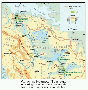
the North Western part of Canada into the Boufort Sea. Six major sub-basins comprise the Mackenzie
system (Athabasca, Peace, Great Slave, Lower Liard, Great Bear, and Peel), three major lakes (Athabasca,
Great Slave, and Great Bear), and three major river deltas (Peace-Athabasca Delta, Slave River Delta, and
Mackenzie Delta). The hydrologic regime of the Mackenzie Basin is influenced by the major physiographic
regions (Western Cordillera, Interior Plain, Precambrian Shield and Arctic Coastal Plain), permafrost
which covers a significant portion of the basin, and vegetation which varies from Boreal forest to Arctic
and alpine tundra.
|