
- About Us
- People
- Undergrad
- Graduate
- Research
- News & Events
- Outreach
- Equity
- _how-to
- Congratulations to our Class of 2021
- Archive
- AKCSE
- Atlas Tier 1 Data Centre


Map & Directions
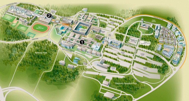
1. Department of Physics
1. Visitors' Parkade
For detailed maps of the SFU campuses, please follow the links below.
Map of SFU Burnaby
Map of SFU Vancouver
Map of SFU Surrey
If you are coming to campus for the first time, stop at the Transportation Centre for directional assistance.
For information on taking transit, carpooling and walking, please visit SFU's page on alternative transportation.
HOW TO GET TO SFU
You can also use google maps or mapquest for driving directions and maps.
From the East:
Trans-Canada Highway (Highway 1) going west -- take the Gaglardi Way exit 37.
Lougheed Highway (Highway 7) going west -- turn right (north) onto Gaglardi Way.
From the West:
Trans-Canada Highway (Highway 1) going east -- take the Gaglardi Way exit 37.
Lougheed Highway (Highway 7) going east -- turn left (north) at Gaglardi Way.
Hastings Street (Highway 7A) going east -- take the right lane exit at the traffic light at Barnet Highway (just past a pedestrian overpass). Continue onto Burnaby Mountain Parkway.
From the South:
Trans-Canada Highway (Highway 1) going north west -- take the Gaglardi Way exit 37.
From the Vancouver airport:
Take Marine Way (east). Turn left (north) onto Boundary Rd. Turn right (east) onto Lougheed Highway. Turn left (north) onto Gaglardi Way.