Home Page
Study Design
Background Research
Data
Acquisition
Spatial
Analysis
Methodological
and Operational Errors
Conclusion
References
Where in the GVRD is
the most suitable location to put a new skate park? This is the
question that the multi-criteria evaluation intends to answer. The
project design for this multi-criteria evaluation is evident in the
cartographic model created for this location analysis project. The cartographic model can be seen below.
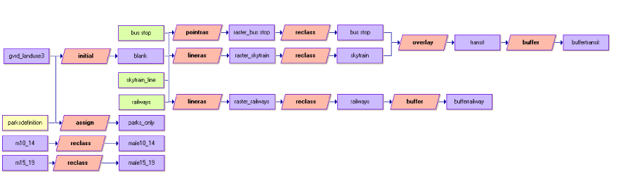
Cartographic
Model: The yellow colored rectangles symbolize an attribute values
file. The violet coloured rectangles symbolize a raster image. The lime
green coloured rectangles symbolize a vector image. The peach coloured
polygons symbolize an Idrisi module.
The
gvrd_landuse3 image and the parks definition attribute values file was
used as inputs in the assign module to create a boolean image of only
the recreation and protected natural areas land use category. The
initial module, using the define individually option, in order to have
all of the parameters, like number of rows and columns, of the
gvrd_landuse3 image present in the images to follow.
In the process of creating the distance from
railways criteria, there were a few steps along the way. The lineras module
was added to the railways vector images to turn them
into raster images. Similar to the
above problem with the SkyTrain and bus stop data, the raster_railways
image needed to be reclassed, because each of the line segments was
shown in the image based on their object identification number. The
image for the multi-criteria evaluation needed to become a boolean
image so all of the individual railway segments needed to become one in
the image. To view the resulting railway image click here.
In order to have the two
population density of males factor images ready for the multi-criteria
evaluation they first needed to be reclassed to get rid of the -9999
values (null values).
All of the data needed to be in a
common projected coordinate system, which was conducted in the ArcGIS
software program. Nad 1983 UTM
Zone 10N was chosen as the common projection for all of the shapefiles
because it is a good projection for the size of the GVRD. The GVRD land use data
stated
in its accompanying text file that the data was used in UTM Zone 10N and
a datum of Nad 1983, but this data still needed to be projected, which
it was. The TransLink data and the Census 2001 spatial data also needed
to be projected into Nad 1983 UTM Zone 10N. The railway data was already projected.
« Previous Page
Next Page »


