Home - Background - Data Acquisition - Methodology - Spatial Analysis - Problems - Discussion - References
Data Acquisition__________________________________________________________________________
Data was acquired from the BC Biogeoclimatic data set, the BTM Landuse Version 1 set, the BC parks data set, the CanRoad and CanWater data set (all shapefiles), as well as from the Species at Risk Act (SARA) website.
From the BC Biogeoclimatic data set, a new layer was created for the Coastal Douglas Fir (CDF) and Coastal Western Hemlock (CWH) zones by selecting them by attributes in ArcMap. These are the biogeoclimatic zones that the Pacific Water Shrew is located within according to the Ministry of Environment branch of the Government of British Columbia. These zones reach elevations of up to 1000 meters A.S.L., which is within the elevation range requirement of the Pacific Water Shrew.
Old (equal to or greater than to 140 years of age) and young (less than 140 years of age) forest, agricultural, urban, and wetland land use data were attained from the BTM Landuse shapefile in ArcMap. They were each selected by attributes, and created into new shapefiles. These were chosen because the Pacific Water Shrew is more preferential to wetland areas, as well as old forest than to young forest, but requires either to survive. Agricultural and urban landuse have negative effects on the habitat of the Pacific Water Shrew by fragmenting and isolating potential habitat areas. The further away these landuses are, the more suitable land becomes due to less pollutant runoff.
![]()
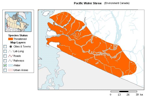
The Environment Canada Species at Risk Web Mapping Application was used to acquire a range area for the Pacific Water Shrew. Using this image as a reference, a current range area was digitized using ArcMap. Reference points used when creating this included rivers, lakes, and the border between Canada and the United States.
From the DMTI data sets in the S drive, CanMap water and park data were acquired. For water data, the BCmnwtl stream and river data water and BCmjwtr major water bodies data files were used. Fresh water areas are key to the Pacific Water Shrew's survival. Parks were chosen because they tend to be forested areas that are more protected than other areas. An additional data set for parks was acquired from the Ministry of Energy, Mines, and Petroleum Resources Geospatial Data Downloads website.
From the CanMap park data set, certain types of parks were selected from the attribute table, as some types of "parks", such as cemetaries, were seen as insignificant compared to others, such as provincial parks or wildlife habitat areas. The types of parks selected from the park data were parks or sport field areas, campgrounds, national wildlife areas, and provincial parks.
CanMap road data was also acquired from the DMTI data set CanMap street files in the S drive. The BCrds data file for roads was used since it contained not only main roads such as highways, but other main and side roads as well. Roads and the area surrounding them indicate less suitable areas because they fragment potential habitat areas, and can be a source of pollution.
All of these data were clipped in ArcMap to the Region layer, since this is the area of concern, and all were projected to the NAD 1983 UTM Zone 10N coordinate system. Once in IDRISI, the project module was used to project the different data to the extent of the region.
Jacquelyn Shrimer ~ jshrimer@sfu.ca ~ Geog 355