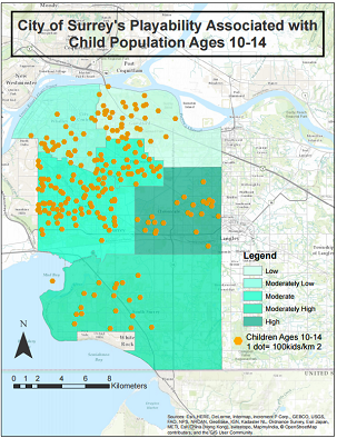
The steps highlighted in the Methodology section produced final outputs in the form of maps. The final outputs were based off our research and the overall objective of the report, in addition to our clients' request. The first 2 maps are the overall factors that create the Built Urban Environment, while Crime is part of the social neighbourhood environment that is well associated to the BUE. The final map produced is the suitability map of the 6 dissemination areas in Surrey (Whalley, Guildford, Fleetwood, Newton, Cloverdale, and South Surrey). Additionally, the Child density in Surrey layer was overplayed to produce the Suitability map against Child density.