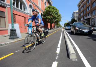
protected bike lane/cycle track: a paved exclusive one-way or two-way cycling facility that can be at road, sidewalk or an intermediate level that is physically separated from both vehicular and pedestrian traffic by a curb or barrier.
Definitions
AAA active transportation network: Continuous and connected street infrastructure, including physically separated bike lanes as well as shared roadways and multi-use trails, that supports “All Ages and Abilities” in walking and cycling to common everyday destinations. The City of Victoria is building a network of safe connected bicycle routes across the entire city to support and encourage more people who live, work, play and visit Victoria to ride bikes.
mid-sized city: Our reseatch team has defined a mid-sized city as an urban centre with a population of 50,000 to 500, 000. In Canada this includes about a third of all cities (approximately 55 of 155 cities) and as of 2016, about 8.3 million of the 35 million total national population.
GIS: Geographic Information Systems are designed to capture, store, manipulate, analyze, manage, and present spatial or geographic data.
health impacts: Includes measures of physical activity in recreation/leisure, transportation and work activities (comparing to the 150 min/week Canadian guideline); self-reported health and mobility; crash, falls and other safety incidents relating to bicyclists on the roadway.
spatial equity impacts: Changes in real and perceived geographic and logistical access to bicycling infrastructure by neighbourhood deprivation (average income). Our team’s focus will not be social or economic access.
bicycle infrastructure/facilities: Roads, pathways and urban landscape features designed to. This includes the full spectrum of traffic calming features as well as buffers designed to separate and protect bicyclists from motor vehicles including but not limited to paint, to raised curbs to intersection features. Bicycle infrastructure types include protected bike lanes (aka cycle tracks), multi-use off-street paths, AAA local street bikeways, signed residential bike route and painted bike lanes. IBIMS uses The Canadian Bikeway Comfort and Safety (Can-BICS) as a guide. Further details of different kinds of common bicycle infrastructure and facilties defined here below.

multi-use off-street paths: an off-street paved path reserved for bikes, including those adjacent to pedestrian paths OR an off-street paved path shared with pedestrians, cyclists, and other users with or without directional separation and built using a range of surface material.
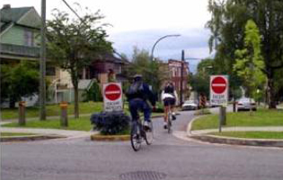
AAA local street bikeway: a local street (no centre line or lanes) where cyclists share the roadway with motor vehicles. Traffic calming elements limit motor vehicle speeds and volumes and inhibit their through travel. Bicycle priority measures facilitate cyclists’ safe crossing of streets and limit stops and delays. The facility includes measures to improve cyclist comfort: smooth surfaces; street lighting; wayfinding signage and pavement markings; and consistent paving material and colour.

signed residential bike route: a local street shared roadway with bicycle route wayfinding signage or roadway pavement markings. The street lacks traffic calming and diversionary elements needed to minimise motor traffic volumes and speeds or bicycle-friendly crossing treatments at major streets.
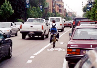
on-street painted bike lanes: a marked bike lane on the street, with or without parked cars. Infrastructure is designated by means of pavement striping, markings and signage that is located adjacent to vehicular traffic.