Selected Publications
(Names of group members labeled with *)
Bing Lu, Ian McDonald*, Jonathon McIntyre. 2026. Investigating the 2021 cross-border flooding in Washington, USA, and British Columbia, Canada and associated influencing factors using multi-type remote sensing. Geomatics, Natural Hazards and Risk 17(1).


Pengpeng Zhang*, Bing Lu, Jiali Shang, Changwei Tan, Shuchang Sun, Zhuo Xu, Junyong Ge, Yadong Yang, Huadong Zang, and Zhaohai Zeng. 2026. CTGNN: UAV-satellite cross-domain transfer learning for monitoring oat growth in China’s key production areas. Artificial Intelligence in Agriculture 16, no. 1: 630-642.
Pengpeng Zhang*, Bing Lu, Jiali Shang, Shuaijie Shen, Junyong Ge, Xingyu Wang, Shuchang Sun, Yadong Yang, Huadong Zang, Zhaohai Zeng. 2026. PROSAIL-DNN: A Fine-Tuning Transfer Learning Framework for Field-Scale Oat Leaf Area Index Monitoring from UAV Imagery. Computers and Electronics in Agriculture 241: 111272.

Pengpeng Zhang*, Bing Lu, Junyong Ge, Jiali Shang, Changwei Tan, Xingyu Wang, Feng Ding, Shuaijie Shen, Yunfei Jiang, Yadong Yang, Huadong Zang, and Zhaohai Zeng. 2025. A Sustainable Learning Framework: UAV-based Oat Chlorophyll Monitoring Using Radiative Transfer Models and Deep Learning Techniques. IEEE Transactions on Geoscience and Remote Sensing. 63: 1-13.
Bing Lu, Lucie Francescutto*, Sarah Howie, Hui Lin, Qiusheng Wu, Nicholas Hedley, Ali Jamali*, Ian McDonald*. 2025. Exploring the Concept of Digital Twins of Wetlands for Supporting Ecosystem Monitoring and Management. Big Earth Data. 1-31
Pengpeng Zhang*, Bing Lu, Jiali Shang, Changwei Tan, Qihan Xu, Lei Shi, Shujian Jin, Xingyu Wang, Yunfei Jiang, Yadong Yang, Huadong Zang, Junyong Ge, and Zhaohai Zeng. 2025. TKSF-KAN: Transformer-enhanced Oat Yield Modeling and Transferability Across Major Oat-Producing Regions in China using UAV Multisource Data. ISPRS Journal of Photogrammetry and Remote Sensing 224: 166-186.

Ali Jamali*, Swalpa Kumar Roy, Bing Lu, Leila Hashemi Beni, Nafiseh Kakhani, Pedram Ghamisi. 2025. MSHCCT: A Multi-Scale Compact Convolutional Network for High Resolution Aerial Scene Classification. IEEE Geoscience and Remote Sensing Letters. 1-5.
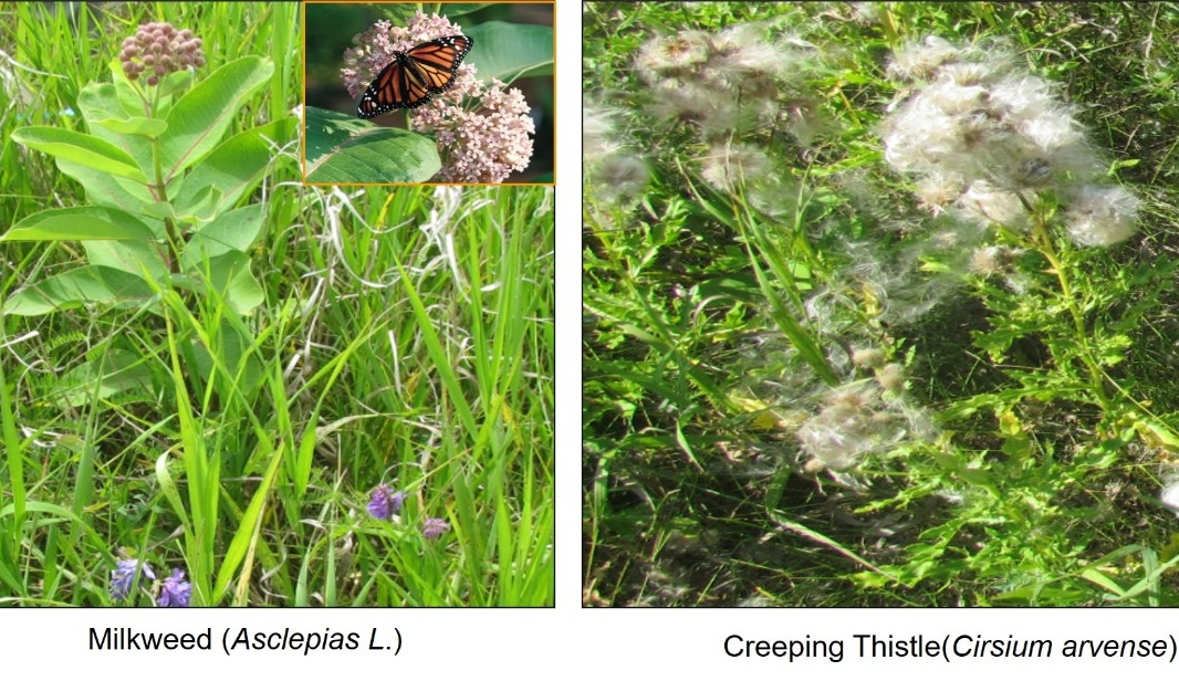
Lilian Yang*, Bing Lu, Margaret Schmidt, Sowmya Natesan, David McCaffrey. 2025. Applications of Remote Sensing for Crop Residue Cover Mapping. Smart Agricultural Technology. 11: 100880.
Ali Jamali*, Bing Lu, Eric M. Gerbrandt, Carolyn Teasdale, Rishi R. Burlakoti, Siva Sabaratnam, Jonathon McIntyre, Lilian Yang*, Margaret Schmidt, David McCaffrey, and Pedram Ghamisi. 2025. High-resolution UAV-based blueberry scorch virus mapping utilizing a deep vision transformer algorithm. Computers and Electronics in Agriculture 229: 109726.

Phuong D. Dao, Yuhong He, Bing Lu, Alexander Axiotis. 2025. Imaging spectroscopy reveals topographic variability effects on grassland functional traits and drought responses. Ecology. 106(3).
Mederer, Daniel, Hannes Feilhauer, Eya Cherif, Katja Berger, Tobias B. Hank, Kyle R. Kovach, Phuong D. Dao, Bing Lu, Philip A. Townsend, and Teja Kattenborn. 2025. Plant trait retrieval from hyperspectral data: Collective efforts in scientific data curation outperform simulated data derived from the PROSAIL model. ISPRS Open Journal of Photogrammetry and Remote Sensing: 100080.
Pengpeng Zhang*, Bing Lu, Xingyu Wang, Junyong Ge, Yadong Yang, Jiali Shang, Huadong Zang, Zhaohai Zeng. 2025. Using UAV-Based Multispectral and RGB Image Data to Monitor the Above-Ground Biomass of Oat-based Diversified Cropping. European Journal of Agronomy, 162

Pengpeng Zhang*, Bing Lu, Jiali Shang, Xingyu Wang, Zhenwei Hou, Shujian Jin, Yadong Yang, Huadong Zang, Junyong Ge, and Zhaohai Zeng. 2024. Ensemble learning for oat yield prediction using multi-growth stage uav images. Remote Sensing 16, no. 23: 4575.
Ali Jamali*, Swalpa Kumar Roy, Danfeng Hong, Bing Lu, Pedram Ghamisi. 2024. How to Learn More? Exploring Kolmogorov–Arnold Networks for Hyperspectral Image Classification. Remote Sensing. 2024; 16(21):4015.
Ali Jamali*, Swalpa Kumar Roy, Bing Lu, Avik Bhattacharya, Pedram Ghamisi. 2024. PolSARConvMixer: A Channel and Spatial Mixing Convolutional Algorithm for PolSAR Data Classification. IGARSS 2024 - 2024 IEEE International Geoscience and Remote Sensing Symposium, Athens, Greece.
Ali Jamali*, Bing Lu, Rishi R Burlakoti, Siva Sabaratnam, Margaret Schmidt, Carolyn Teasdale, Eric M Gerbrandt, Lilian Yang*, Jonathon McIntyre, David McCaffrey. 2024. High-resolution mapping of Blueberry scorch virus incidence using RGB and multispectral UAV images and deep learning. Remote Sensing Applications: Society and Environment, 36.

Eya Cherif, Hannes Feilhauer, Katja Berger, Phuong D Dao, Michael Ewald, Tobias B Hank, Yuhong He, Kyle R Kovach, Bing Lu, Philip A Townsend, Teja Kattenborn. 2023. From spectra to plant functional traits: Transferable multi-trait models from heterogeneous and sparse data. Remote Sensing of Environment, 292: 1-16
Parisa Ahmadi*, Shattri Mansor, Hamidreza Ahmadzadeh Araji, and Bing Lu. 2023. Convolutional SVM Networks for Detection of Ganoderma Boninense at Early Stage in Oil Palm using UAV and Multispectral Pleiades Images. ISPRS Annals of the Photogrammetry, Remote Sensing and Spatial Information Sciences 10: 25-30
Emiliano Agrillo, Nicola Alessi, Jose Manuel Álvarez-Martínez, Laura Casella, Federico Filipponi, Bing Lu, Simona Niculescu, Mária Šibíková, Kathryn EL Smith. 2022. Editorial for Special Issue:“New Insights into Ecosystem Monitoring Using Geospatial Techniques”. Remote Sensing 14, 2346: 1-7.
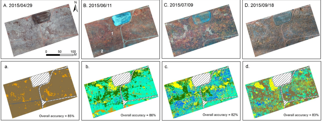
Ian McDonald*, Bing Lu. 2022. Investigating Surface Oscillation at Burns Bog using Interferometric Synthetic Aperture Radar (InSAR). A project report prepared for the City of Delta, British Columbia.
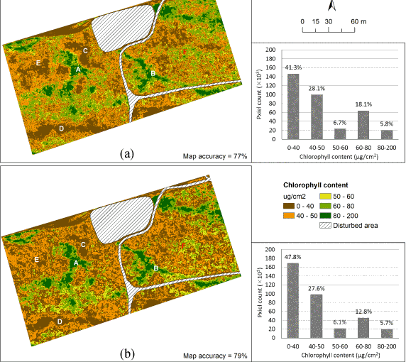
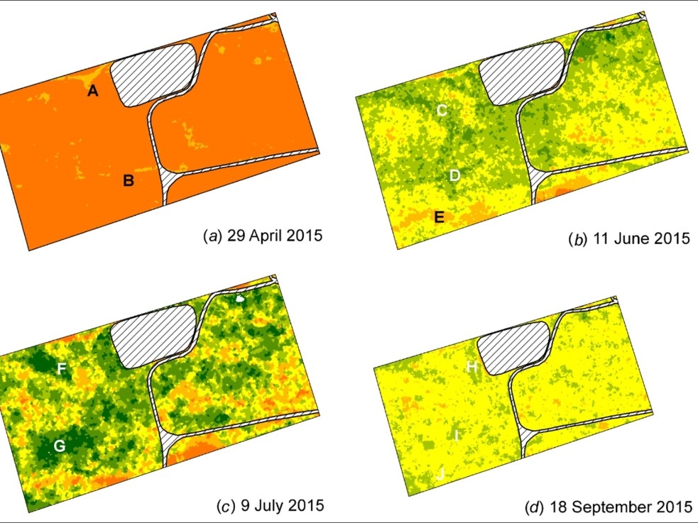
Bing Lu, Yuhong He. 2021. Assessing the Impacts of Species Composition on the Accuracy of Mapping Chlorophyll Content in Heterogeneous Ecosystems. Remote Sensing 13, 4671: 1-26.

Bing Lu, Cameron Proctor, Yuhong He. 2021. Investigating Different Versions of PROSPECT and PROSAIL for Estimating Spectral and Biophysical Properties of Photosynthetic and Non-photosynthetic Vegetation in Mixed Grasslands. GIScience & Remote Sensing 58(3): 354-371.
Bing Lu, Phuong D. Dao, Jiangui Liu, Yuhong He, Jiali Shang. 2020. Recent advances of hyperspectral imaging technology and applications in agriculture. Remote Sensing 12(16): 1-44.
Phuong D. Dao, Yuhong He, Bing Lu. 2019. Maximizing the Quantitative Utility of Airborne Hyperspectral Imagery for Studying Plant Physiology: An Optimal Sensor Exposure Setting Procedure and Empirical Line Method for Atmospheric Correction. International Journal of Applied Earth Observation and Geoinformation, 77: 140-150.
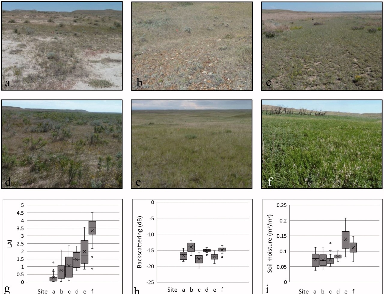
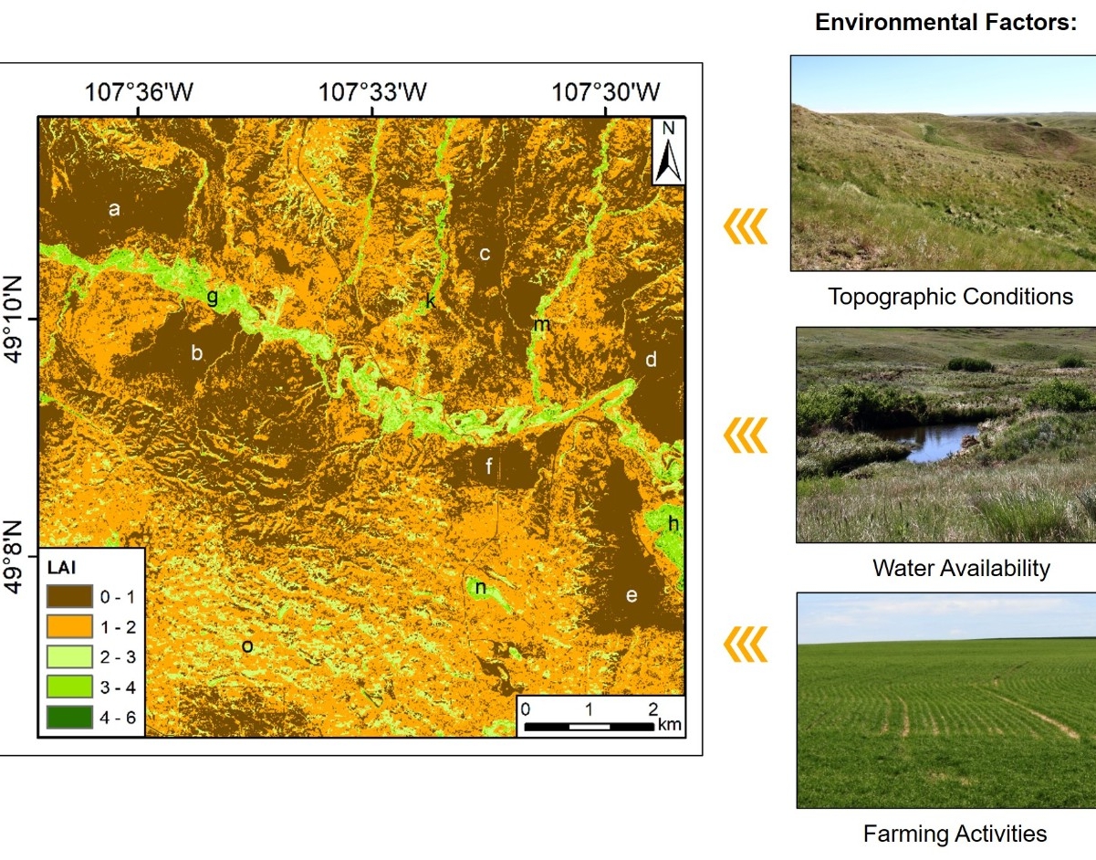
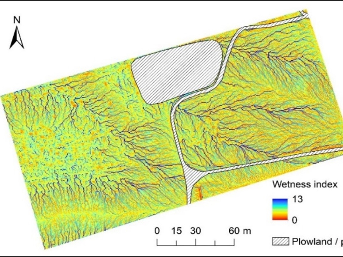
Bing Lu, Yuhong He. 2019. Leaf Area Index Estimation in a Heterogeneous Grassland using Optical, SAR, and DEM Data. Canadian Journal of Remote Sensing, 45, 618-633
Bing Lu, Yuhong He. 2019. Evaluating Empirical Regression, Machine Learning, and Radiative Transfer Modeling for Estimating Vegetation Chlorophyll Content using Bi-seasonal Hyperspectral Images. Remote Sensing. 11(17): 1-22.
Bing Lu, Yuhong He, Phuong D. Dao. 2019. Comparing the Performance of Multispectral and Hyperspectral Images for Estimating Vegetation Properties. IEEE Journal of Selected Topics in Applied Earth Observations and Remote Sensing. 12(6): 1784-1797.
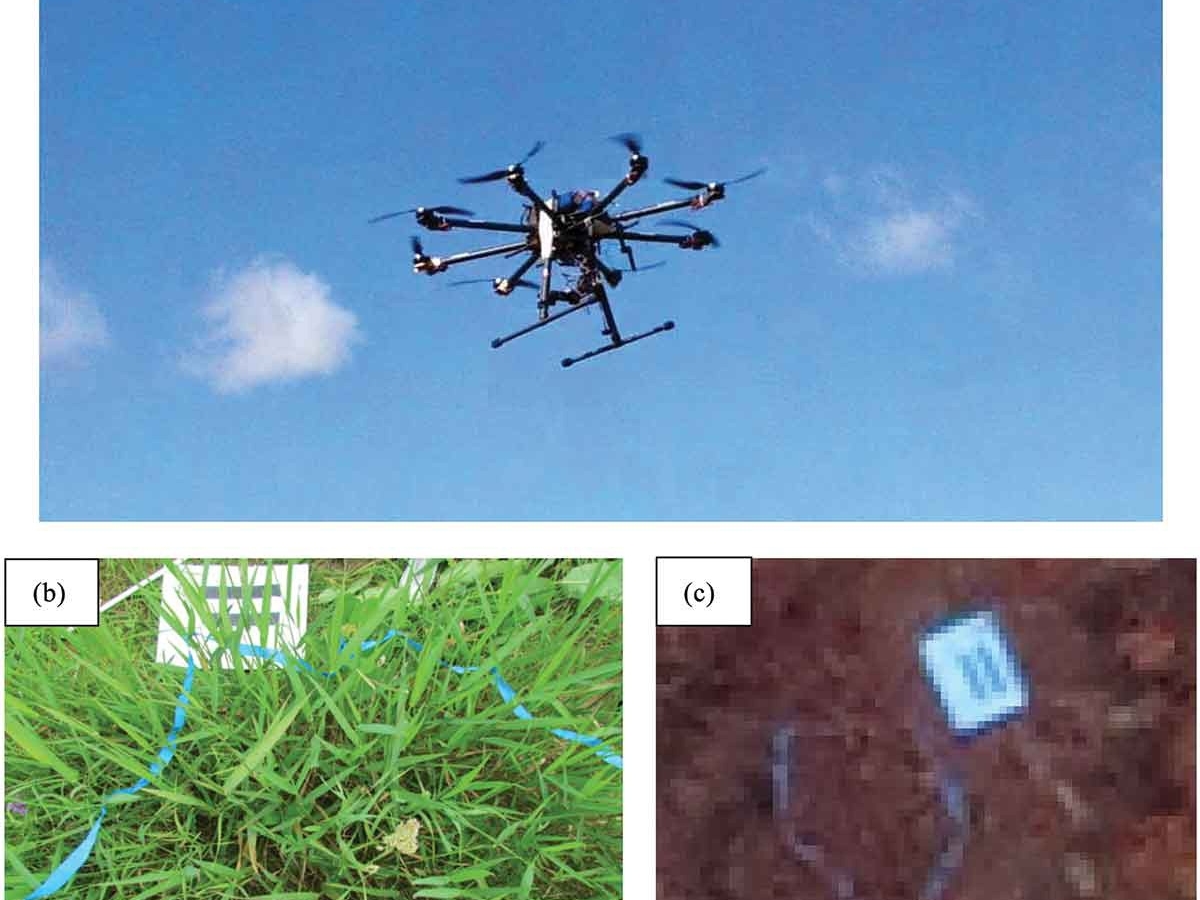
Bing Lu, Yuhong He. 2018. Optimal Spatial Resolution of Unmanned Aerial Vehicle (UAV)-acquired Imagery for Species Classification in a Heterogeneous Grassland Ecosystem. GIScience and Remote Sensing, 55(2): 205-220.
Bing Lu, Yuhong He, Hugh Liu. 2018. Mapping Vegetation Biophysical and Biochemical Properties using Unmanned Aerial Vehicles-acquired Imagery. International Journal of Remote Sensing, 39:15-16, 5265-5287.
Bing Lu, Yuhong He. 2018. UAV-based Multispectral Images for Investigating Grassland Biophysical and Biochemical Properties. Chapter 12 in High Spatial Resolution Remote Sensing: Data, Analysis, and Applications. 245-259. CRC Press. ISBN 9781498767682.
Alexander Tong, Bing Lu, Yuhong He. 2018. Inversion of a Radiative Transfer Model Using Hyperspectral Data for Deriving Grassland Leaf Chlorophyll. Chapter 13 in High Spatial Resolution Remote Sensing: Data, Analysis, and Applications. 261-282. CRC Press. ISBN 9781498767682.
Cameron Proctor, Bing Lu, Yuhong He. 2017. Determining the Absorption Coefficients of Decay Pigments in Decomposing Monocots. Remote Sensing of Environment, 199:137-153.
Bing Lu, Yuhong He. 2017. Species Classification using Unmanned Aerial Vehicle (UAV)-acquired High Spatial Resolution Imagery in a Heterogeneous Grassland. ISPRS Journal of Photogrammetry and Remote Sensing, 128:73-85.
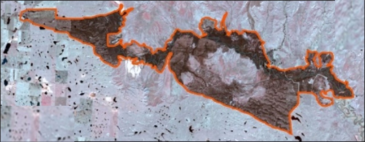
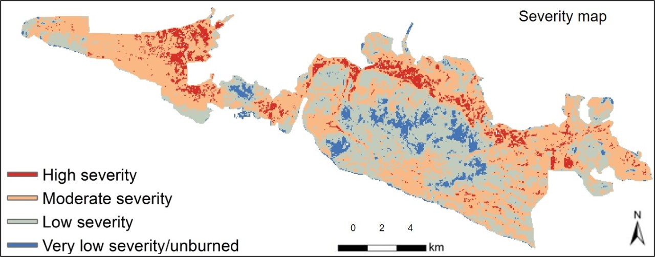
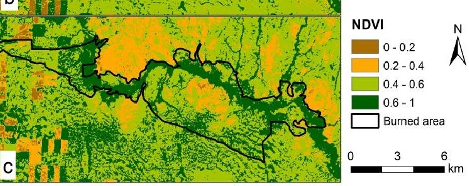
Bing Lu, Yuhong He, Alexander Tong. 2016. Evaluation of Spectral Indices for Estimating Burn Severity in Semiarid Grasslands. International Journal of Wildland Fire, 25(2):147-157.
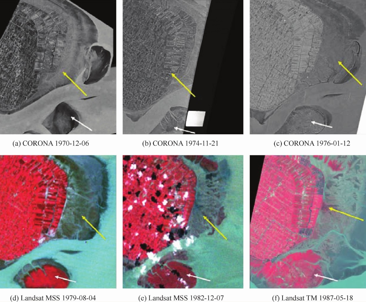
Xuezhong Jiang, Bing Lu, Yuhong He. 2013. Response of the Turbidity Maximum Zone to Fluctuations of Sediment Discharge from River to Estuary in the Changjiang Estuary (China). Estuarine, Coastal and Shelf Science, 131:24-30.
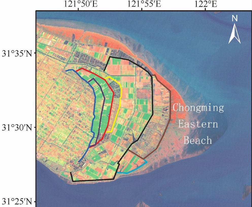
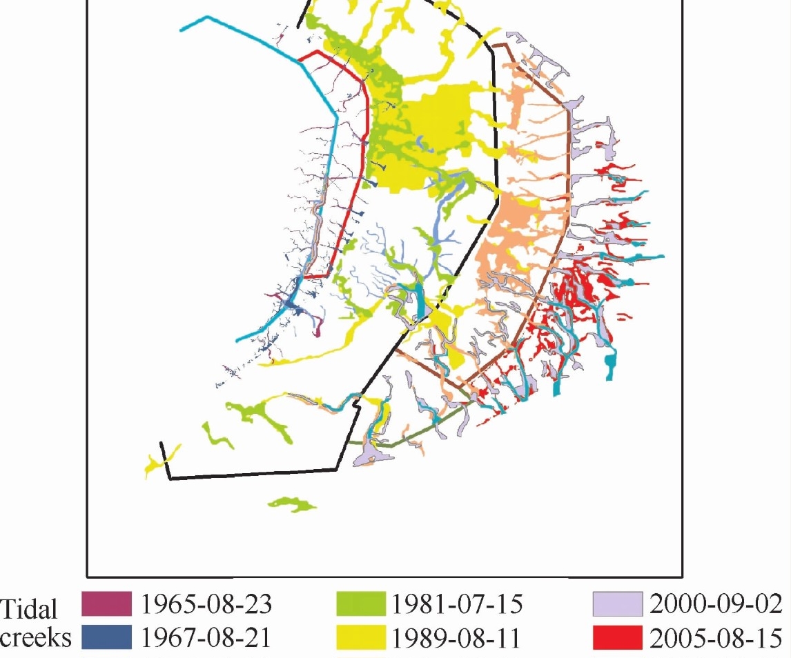
Bing Lu, Xuezhong Jiang. 2013. Reclamation Impacts on the Evolution of the Tidal Flat at Chongming Eastern Beach in Changjiang Estuary. Journal of Remote Sensing, 17(2):335-349.
F T I