Methodology
IDRISI’s graphic modeling environment, Macro Modeler, provides a graphic representation of the algorithm and shows the processing flow from the beginning to the end of the method. In order to define the suitability of an area for a specific practice, several criteria need to be evaluated. The methodology applied integrates a Multi-criteria Evaluation (MCE) method within the Geographic Information Systems (GIS) environment. Multi-criteria/Multi-objective decision models were produced for each lodgepole pine and white spruce species. Hydrological features were set as a constraint because trees are not to be planted in rivers and other bodies of water. Input factors (i.e. elevation, aspect, slope, soil, and proximity to rivers) were standardized to a scale of 0-255 where 0 is not suitable and 255 is perfectly suitable (i.e. the darker the output the better the suitability). The same methodology was repeated and applied to each tree species.
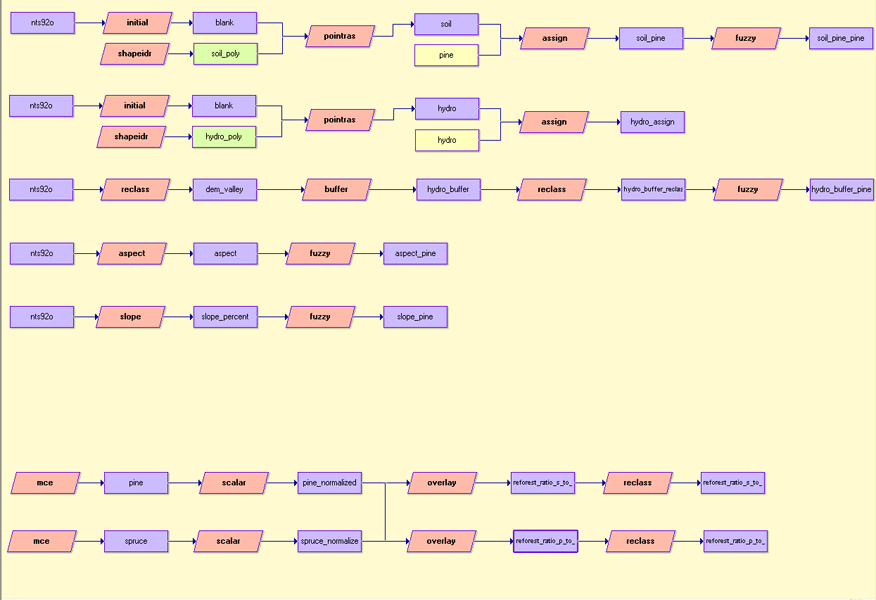 Macro Modeler |
The MCE in its Weighted Linear Combination (WLC) method introduces a soft or “fuzzy” concept of suitability in standardising criteria. Instead of hard Boolean decision of assigning absolute suitability or unsuitability to a location for a given criteria, it is scaled to a particular common range where suitable and unsuitable areas are continuous measures. The quantitative factor images were standardized using the IDRISI’s module FUZZY
The table the factor standardization for pine:
|
Factor file |
Membership function type |
Membership function shape |
Control points |
|
Elevation |
Monotonically increasing |
Sigmoidal |
a = 0
|
|
Aspect |
Symmetric |
Sigmoidal |
a = 0
|
|
Slope |
Monotonically decreasing |
Sigmoidal |
a = 0
|
|
Soil |
Monotonically increasing |
Linear |
a = 0
|
|
Proximity to river |
Monotonically increasing |
Sigmoidal |
a = 0
|
The table the factor standardization for spruce:
|
Factor file |
Membership function type |
Membership function shape |
Control points |
|
Elevation |
Symmetric |
Sigmoidal |
a = 326
|
|
Aspect |
Symmetric |
Sigmoidal |
a = 0
|
|
Slope |
Monotonically decreasing |
Sigmoidal |
a = 0
|
|
Soil |
Monotonically increasing |
Linear |
a = 0
|
|
Proximity to river |
Monotonically decreasing |
Sigmoidal |
a = 0
|
The MCE is implemented using the Experts Systems Modelling approach of Analytical Hierarchy Process (AHP. The AHP orders critical factors into a hierarchy of importance. It also allows criteria to tradeoff with each other depending on the importance weights assigned to them. Furthermore, AHP can deal with criteria that are interdependent, both from the effect on land and in the interaction between spatial units. In the procedure for Multi-Criteria Evaluation using WLC, it is necessary that the weights sum to one. In AHP, these weights are calculated by taking the principal eigenvector of a square reciprocal matrix of pairwise comparison between the criteria. All possible pairs of criteria are compared by experts on a 9- point continuous scale for their relative importance in determining the suitability. Both tree species used the same weights.
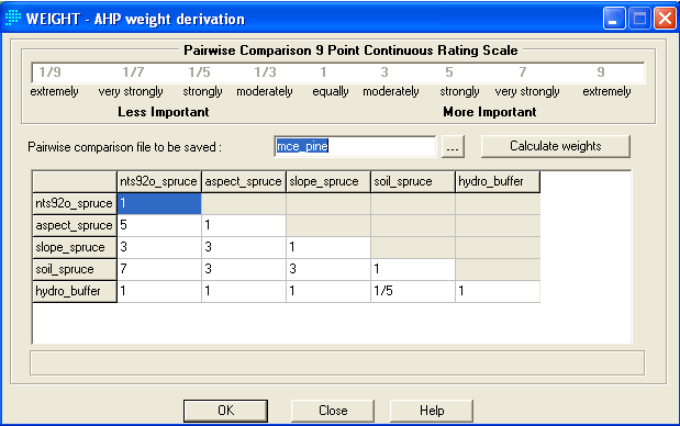 Pairwise comparison |
The eigenvector of weights is :
elevation : 0.0632
aspect : 0.1481
slope : 0.2045
soil : 0.4690
hydro_buffer : 0.1151
Consistency ratio = 0.10
^ top