
 GRIZZLY BEAR HABITAT
Conceptual
Idea
 When multiple agencies or organizations create similar
GIS analyses around a controversial resource management issue, are institutional
mandates and objectives of the respective agencies responsible for variations
in the maps and data produced? The technology of GIS has greatly enhanced
the ability of natural resource data to be visualized and this data is playing
an increasing role in representations of wildlife habitat (IBM Report). Two
ministries within the British Columbia government and numerous ENGO's are
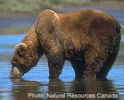
using GIS to analyze spatial data in order to produce grizzly bear (Ursos
arctos) capability and suitability maps. The descriptive
potential of the maps produced from such analyses serve as powerful tools
for shaping public perception and the decision making process (McKendry, 2000).
The Ministry of Water, Land and Air Protection (MoWLA) is working with
the Grizzly Bear Scientific Panel and the Wildlife Branch to develop sustainable
harvesting levels of grizzly bears in BC. The Ministry of Sustainable
Development is using gizzly bear habitat maps as one of its base spatial
information data sets to advise the Central Coast Land and Resources Management
Plan (LRMP). In both of these cases, GIS is employed for analysis
by the BC government early on in the planning process and the decisions
are subject to other types of information gathering and methods of validation.
The Round River Conservation Institute completed a regional
Conservation Area Design (Jeo, 1998) and are in the process of creating another
analysis of grizzly bear habitat in British Columbia with the Craighead
Institute. Assuming that agendas are indeed encoded into models of
reality (Schurman, 2002) then the resultant data of a GIS analysis will reveal
a view of reality held by the creating agency. This is not to suggest
that these agencies and organizations are not aware of the inadequacies of
any spatial modeling strategy. In fact, increasingly agencies are trying
to incorporte local knowledge, field methodology and other forms of verification
into the modeling proccess in order to better simulate reality. Nonetheless,
the data resulting from the GIS analysis is very influential in decisions
made and strategies adopted by these agencies.
When multiple agencies or organizations create similar
GIS analyses around a controversial resource management issue, are institutional
mandates and objectives of the respective agencies responsible for variations
in the maps and data produced? The technology of GIS has greatly enhanced
the ability of natural resource data to be visualized and this data is playing
an increasing role in representations of wildlife habitat (IBM Report). Two
ministries within the British Columbia government and numerous ENGO's are
using GIS to analyze spatial data in order to produce grizzly bear (Ursos
arctos) capability and suitability maps. The descriptive
potential of the maps produced from such analyses serve as powerful tools
for shaping public perception and the decision making process (McKendry, 2000).
The Ministry of Water, Land and Air Protection (MoWLA) is working with
the Grizzly Bear Scientific Panel and the Wildlife Branch to develop sustainable
harvesting levels of grizzly bears in BC. The Ministry of Sustainable
Development is using gizzly bear habitat maps as one of its base spatial
information data sets to advise the Central Coast Land and Resources Management
Plan (LRMP). In both of these cases, GIS is employed for analysis
by the BC government early on in the planning process and the decisions
are subject to other types of information gathering and methods of validation.
The Round River Conservation Institute completed a regional
Conservation Area Design (Jeo, 1998) and are in the process of creating another
analysis of grizzly bear habitat in British Columbia with the Craighead
Institute. Assuming that agendas are indeed encoded into models of
reality (Schurman, 2002) then the resultant data of a GIS analysis will reveal
a view of reality held by the creating agency. This is not to suggest
that these agencies and organizations are not aware of the inadequacies of
any spatial modeling strategy. In fact, increasingly agencies are trying
to incorporte local knowledge, field methodology and other forms of verification
into the modeling proccess in order to better simulate reality. Nonetheless,
the data resulting from the GIS analysis is very influential in decisions
made and strategies adopted by these agencies. Many issues of habitat assessment are wrought
with problems of data quality, data reliability and data interpretation.
The development of the individual layers in the data model can represent
sources of inaccuracy and misrepresentation of the landscape.
For example, the definition of old forest by the BTM data (trees older than
140yrs) verses a more complex definition of old growth structure used
by the Sierra Club (multi-structured in terms of species and structural
diversity & trees older than 250 years) will produce very different
data sets. Likewise, will the determination of which land classifications
in the landscape represent prime habitat. This project seeks to study
how the final evaluation of criteria in the model building process can influence
the overall outcome. It asks what would happen if habitat structures
were emphasized in the decision making process as opposed to emphasizing
the influence that human activity might have? Recognizing the influence
that social objectives have in influencing the development of a GIS analysis
are important because once a model is encoded in GIS, in manufactures entities
that gain a materiality as they enter into the parlance of science and society
(Schuurman, 2002). They may initially be treated as 'hypothetical',
as in the early stages of the LRMP, but over time they become 'normalized
and institutionalized' (ibid). Nonetheless, the predictive abilities
of GIS to help scientists and policy makers better understand the world coupled
with a society that embraces the creation of scientific knowledge ensure
the continued use of GIS derived data in the decision making process.
Many issues of habitat assessment are wrought
with problems of data quality, data reliability and data interpretation.
The development of the individual layers in the data model can represent
sources of inaccuracy and misrepresentation of the landscape.
For example, the definition of old forest by the BTM data (trees older than
140yrs) verses a more complex definition of old growth structure used
by the Sierra Club (multi-structured in terms of species and structural
diversity & trees older than 250 years) will produce very different
data sets. Likewise, will the determination of which land classifications
in the landscape represent prime habitat. This project seeks to study
how the final evaluation of criteria in the model building process can influence
the overall outcome. It asks what would happen if habitat structures
were emphasized in the decision making process as opposed to emphasizing
the influence that human activity might have? Recognizing the influence
that social objectives have in influencing the development of a GIS analysis
are important because once a model is encoded in GIS, in manufactures entities
that gain a materiality as they enter into the parlance of science and society
(Schuurman, 2002). They may initially be treated as 'hypothetical',
as in the early stages of the LRMP, but over time they become 'normalized
and institutionalized' (ibid). Nonetheless, the predictive abilities
of GIS to help scientists and policy makers better understand the world coupled
with a society that embraces the creation of scientific knowledge ensure
the continued use of GIS derived data in the decision making process.