Effectiveness of GIS in assesinggrizzly

grizzly 
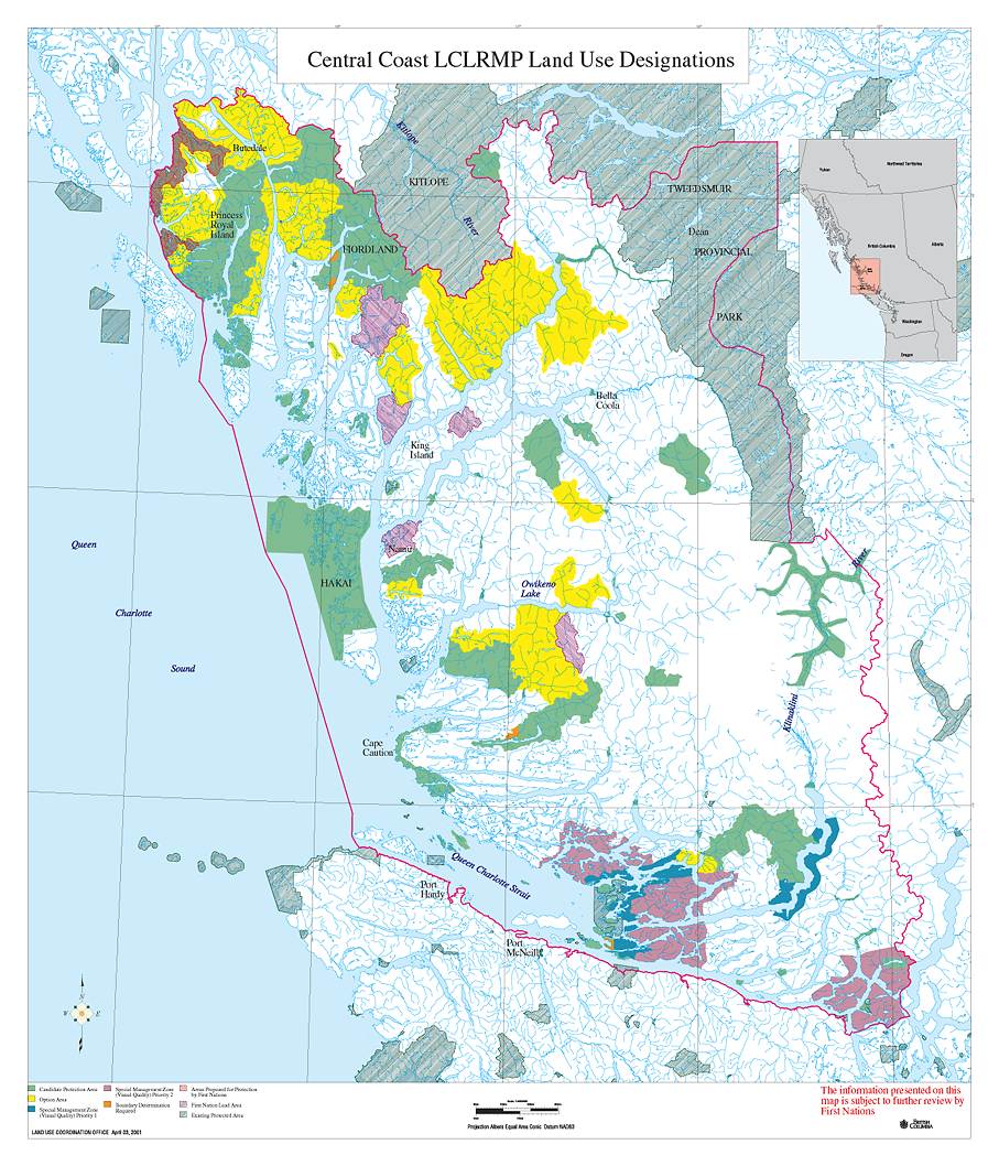
GRIZZLY BEAR HABITAT

In the Central Coast of Brittish Columbia.


Introduction:


    The following provides a contextual background of the ways GIS is currently being used in the province to represent Grizzly Bear (Ursos arctos) habitat and population estimates.  Over the past decade the central coast has received an extraordinarily high level of international and domestic attention over issues of forest conservation.  The region is also home to some of the largest in tact temperate old growth forests in the world and is economically dependent upon the extraction of this timber.  Central coast communities have been harmed by ongoing land-use disputes, market campaigns and resource industry adjustments (MoSRM, 2002). Rich valley bottoms in the Coastal Western Hemlock Zone are important grizzly bear habitat (MoF-2001) and also offer the most valuable lumber (MacHutchon, 1993).  This has led to a conflict between conservation strategies and resource extractive industries who are both currently re-mapping the coast to include intrinsic values, ecosystem function and consumptive values (Clapp, 2002).  The derivation of population estimates for ascertaining the Annual Allowable Harvest of grizzly bears is also quite controversial.  Increasingly, GIS is being used to assist in these spatial analyses and to assist the decision making process where multiple criteria are assessed.    
    Debate among government, industry and environmental representatives over the issue of conservation of an area within the temperate rainforest of BC as a sanctuary for Grizzly Bears has been undertaken for years with no resolution (Davradou, 2001).  All actors agree of the need to manage for the sustainability of grizzly bear populations, but they disagree over how to actualize this goal.  Disagreements center over the management and/or protection of low-elevation old-growth habitat and the issue of sustainable mortality.  Davradou (2001) applies this controversial issue to a range of ethical theories and reveals that they agree on the need for protection of habitat but disagree on whether the protection of the last surviving grizzly bears should out weigh the interests of cultural needs of humans.  The divide centers on ideological differences but it is the science and the creation of habitat and population models that are politically open to scrutiny.  


Central Coast Land and Resource Management Plan
Grizzly Bear Hunt
Environmental NGOs


        Click here to enlarge map                          Central Coast Land and Resource Management Plan
central coast map  
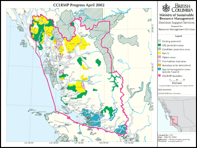
The Ministry of Sustainable Resource Management (MoSRM) is currently developing a Land and Resource Management Plan (LRMP) for the Central Coast of British Columbia.  This is a broad plan for how the land and resource will be used in the future, representing an administrative approach that is committed to 'balancing' the perceived interests of various stakeholders (Jeo, et al, 1998).  The plan area 
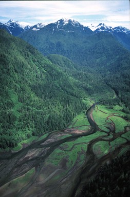
covers 3.8 million ha and is home to over 4,400 people, mainly First Nations. 
    In an attempt to address issues of conservation, the former NDP government presented a goal of preserving %12 of BC in 1992.  A draft proposal of this plan is currently being reviewed. One of the early steps in the planning process requires the development of the process design, identification of issues and the assemblage of land and resource information.  The Central Coast LRMP used GIS to create descriptive and derivative resource information including base maps, protected areas, biodiversity, forestry, geology and agriculture.  One of the biophysical derivative data sets used to assist in making value-based tradeoff decisions among conflicting resource uses and activities was the habitat capability and suitability maps generated for the grizzly bear.  (MoSRM).     The grizzly bear habitat data and maps were one of the key wildlife layers used to develop the provinces Protected Areas Strategy.  A criticism by environmental groups of this process is that conservation indications are subordinated to the perceived sociopolitical interests of stakeholders and the resultant protected areas do not represent an ecological baseline (Jeo, 1998)
    Important studies that serve as much of the foundation for knowledge on habitat selection, mortality, denning, and movement in B.C. are the Khutzeymateen Valley Grizzly Bear and the Flathead River Drainage studies.   The Khutzeymateen project, conducted between 1989 and 1991, collected a wide range of information on grizzly bears in the area using radio-telemetry and field observations in order to estimate population density and determine habitat value, with the goal of then being able to evaluate the impact of proposed land use scenarios.  They determined that the productive lower slopes and valley bottoms in the Khutzeymateen study area that are the best timber growing sites are also some of the best bear habitat thus, putting conventional timber extraction and the maintenance of grizzly bear habitat in direct conflict  (MacHutchon, 1993).  The Flathead River study (McLellan, 2001) looked at the effects of sex, ageclass and season on habitats and elevations selected by 56 radio-collared grizzly between 1979 and 1995 in Southeastern B.C. and revealed that bears in this region preferred selection of avalanche chutes or riparian and low-elevation forests in spring, previously burned areas (50-70yrs) in summer and riparian and forest zones in fall.  
    There is additional work being done with Grizzly bear habitat analysis and GIS under the Forest Practices Code (FPC) in relation to the mandatory requirements for comprehensive ecological planning and environmentally sensitive forest practices.  The Kamloops LRMP (Saxena, 1999) states that wildlife habitat suitability be determined for grizzly bear and other Red and Blue listed species. This analysis utilized a habitat suitability model which consisted of a detailed species account of habitat requirements and associated season of use with a habitat suitability rating scheme that related details from the species account to the relevant ecosystem attributes and ecosystem units for the region.  This habitat assessment was then integrated into the Forest Development Plan through stand and landscape level planning of timber extraction by the Slocan Forest Products Ltd in the Bone Creek drainage (Saxena, 1999). Hood (2001) used GIS to link data about levels of human activity with habitat suitability for grizzly bears in a region within Jasper National Park to estimate habitat effectiveness in supporting bear with and without the effects of human activity in order to offer a predictive tool for planning and management of the area (Hood, 2002).  The development of habitat maps for grizzly bears is used at multiple scales to from the advising of  the local management of timber units to regional development under the LRMP process.  
  
                                                                                           Top of page


 Grizzly Bear Huntgrizzly bear


     In February, 2001, the former NDP government stated a moratorium on grizzly hunting until it could be ascertained that the population of these bears in British Columbia’s Coast Mountains was not threatened.  Less than a year later, the current Liberal government lifted this moratorium and the
grizzly hunt resumed this spring.  A basis for the repeal was that the population of grizzly’s was healthy and that economic incentives of local communities coupled with the killing of ‘problem bears’ warranted the decision.  A key set of information that influenced this decision were estimates of grizzly bear populations of 10,000-13,000, produced as part of the LCMP plan for the central and north coast, were far higher than previously anticipated (Austin, 2002).

    Much of the controversy around the grizzly bear hunt focuses on the population estimates that serve as the foundation of the harvest management system (Austin, 2002).   Critics argue that the hunt should not occur in the absence of a more accurate estimate of population numbers.  Advocates of the current practices of wildlife management counter that it is impossible to accurately predict true numbers of populations and that modeling is a fundamental principle of wildlife management, particularly habitat modeling.   A vocal environmental group, The Raincoast Society, criticizes what they term 'the pseudoscience' used to justify the hunt and claim that virtually all of the grizzly bear could be exterminated in BC by sport hunters and the BC theoretical model would still show a ‘harvestable surplus’  (www.raincoast.org).  
hunters      
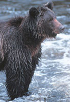
Grizzly Bears are listed as Big Game under the provincial Wildlife Act.  All grizzly bear hunting is regulated through the Limited Entry Hunting (LEH) for residents and Guide Outfitter Quotas (GOQ) for non-residents.  Appropriate levels determined by wildlife biologists based on population models reflecting data from compulsory hunter returns, field inventories and research and the Fuhr-Demarchi habitat suitability models.  The calculation of current habitat suitability  is based upon a GIS model that assigns densities to various habitat types by using classes that are scaled against a benchmark density derived from known research areas such as the Khuzamateen or Flat Head studies.  The estimated impacts of human-caused mortality are then deducted from the habitat potential to arrive at a “stepped down” population est. range (Austin, 2002).  
    Once the population estimates are calculated, the Wildlife Branch determines the Annual Allowable Harvest (AAH) using a stepped down process that subtracts all known mortality (road kills, problem bear kills) and unknown 1% (poaching, train & road kills) from a 4% acceptable mortality rate to arrive at the AAH of just below 3%.   For the 23 year period from 1973 to 2000 there were 8,185 bears killed by all types.  There is an average of 336 (1978-1996) bears killed per year and 236 bears from 1997-2000 period (Austin, 2002).
    Absent from the literature presented by the government is research on the affect that hunting may have on the populations of grizzly bear.  Such as research into the behavioral effect that hunting may have on the aggressive behavior of grizzly bears suggests that bear populations that are not hunted may exhibit very different behaviors than experienced in North America (Russel, 2002).  McLellan and Hovey (2001) research the effects that hunting may have on a population and suggest that population decline and segregation caused by hunting resident adult males can result in population decline and contribute to rapid population extinctions when numbers are small. 

Top of Page


   Environmental Non-Governmental Organizations (ENGO's)


banner        The Sierra Club, the Raincoast Society, Round River, the Nature Conservancy Canada, and the Craighead Institute are all engaging in various re-mapping, education and advocacy campaigns in the central coast around issues of old growth forest and grizzly bears.  A few of these ENGO’s have been involved with strategies of developing parallel GIS analyses and challenging the government’s decisions both by direct action and litigation.  In 1996 the Round River institute was commissioned to develop a Conservation Area design for the central coast in order to delineate and prioritize areas for protection and restoration based on current scientific knowledge, tenants of conservation biology and the precautionary principle (Jeo, 1998). A key element of their analysis was using GIS to determine high grizzly bear habitat and to use this as a basis their conservation area design.  A future study could compare resultant data and maps from these analyses because visual examination reveals that watersheds ranked high do not always match.  A project (Norheim, 2002) conducted around old growth forest mapping in the Pacific Northwest revealed that neither mapping strategy is necessarily more accurate as different methodologies were used, but the presence of a second analysis itself is important. awesome valley
    The ENGO’s are also engaged is various direct action and litigation campaigns that have also influenced the decision making process.  Effective education and boycotting campaigns led to the international boycott of lumber harvested from old-growth forests in the region that influenced the current agreement between the lumber companies, ENGOs and the government (Jeo, 1998).  A key element of this campaign was their maps and data about the remaining old growth forests in the central coast from reclassified Land Sat imagery. 
    One of these organizations main criticisms of the government's Annual Allowable Harvest rates are the figures that suggest that only 1% of the population is killed due to unreported causes such as poaching and road kill.  One study of 388 radio-collared grizzly bears conducted in 13 study areas throughout the Rocky and Columbia Mountains suggest that people killed 77-85% of the 99 bears killed.  Legal harvest accounted for 39-44% of the mortalities in areas where legal harvest occured and that without radio-telemtry, management agencies would have been unaware of about half of the deaths of these bears (McLellan, 1999).  This study, in more densely populated set of regions than the central coast, suggests a much higher percentage of the population of these bears is killed by unknown causes then 1%.  The assumption that a 4% mortality rate is an acceptable level of risk is also theoretical and critics question the degree to which scientists understand what is an acceptable level of risk (Primm, 1996).
    ENGO’s are also attempting to influence the grizzly hunt be drawing upon international law.  They look to CITES, the Convention on International Trade in Endangered Species which prevents the harvesting for profit of any endangered species. The European Union (EU) banned under CITES the import of all grizzly bear products on Nov 29, 2001 under the CITES convention because the Scientific Review Group (SRG), consisting of leading wildlife experts, determined that the hunt was unsustainable.  This decision was important because 50% of all grizzlies in BC are hunted by foreigners, 33% of these from the EU (Austin, 2002). 
      In response to this decision, the Canadian government sent a formal response to the SRG showing that the harvest was sustainable based on both the grizzly bear suitability maps and the detailed process of arriving at the AAH.  The SCG reversed their decision on April 2, 2001 under the caveat that the issues remains under review until after the report of the Grizzly Bear Scientific Panel Review, due out this December 2002 (ibid). The Grizzly Bear Independent Scientific Panel is focusing on four areas of investigation, including the methods and process used to develop estimates of grizzly bear population sizes used in allocating harvests (Peek, 2002).


Top of Page


 Conceptual idea     Data Collection      Project Design      Spatial Analysis    Conclusions   Problems

Bibliography


Back to Index