Glossary of Terms
Access Area - The area around each cell-site
where phone calls are directed.
Analog - A system of cellular phone signal transmission based
on the sending of the modulating amplitude of the communication signal.
Avenue - A scripting language used in ArcView GIS
software.
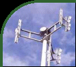
Cell-Site - A cellular phone transmission
tower. (Also known as a cell-tower)
Cell-Splitting - The practice by which a cellular phone company
replaces a single omnidirectional cellular
transmitter with an array of directional
cellular transmitters each pointed in different, opposing, directions.
Cell-splitting results in an increased capacity of a cell-site
because one transmitter has been replaced by a whole array of transmitters.
Convergence Center - Areas (normally buildings) designated as
community gathering places in the event of a natural disaster, such as
an earthquake. Convergence centers commonly include schools, recreation
centers, hospitals, etc.
Coverage/Theme - A map layer in a GIS database.
Digital PCS - See "PCS".
Digital Orthophotography -Digital photography that has been rectified by using known ground positions to
remove distortions in the original photography that are a result of topographic effects and camera tilt.
Digitization - The process of transforming
paper-based spatial information into digital information. In the context
of this project, this mainly involves converting paper maps into digital
coverages in a GIS. [Also see "Heads-up
Digitization"]
Directional Antenna - An antenna,
transmitter, or beacon which transmits its signal in a straight line.
Disaster Response Route - These are selected roadways intended
to provide vital vehicle access in the event of a major disaster. The roads
dedicated for this purpose are supposed to be kept clear for the emergency
and official vehicles for the first stages of disaster recovery.
Flower Tower - A Lattice tower that
narrows near the top.
GIS - A Geographic Information System. A spatially-referenced
geographic database which allows for sophisticated analysis and queries.
Heads-up Digitization - A
method of digitizing where a GIS
operator uses one digital map or photograph on screen to digitize necessary features.
Lattice Tower - A cellular tower
constructed with metal crossbeams supporting its three or four legs. Its
fairly wide base and careful engineering result in a very stable structure
that is able to withstand strong earthquakes.
Liquefaction - A phenomenon where the strength of a soil is reduced
by earthquake shaking or other rapid loading. Liquefaction has the potential
of causing a considerable amount of damage to buildings which are constructed
over unstable soils, such as those of the city of Richmond.
MMI - The Modified Mercalli Index (MMI), sometimes also called
the Modified Mercalli Intensity scale, describes the damage and the intensity
of an earthquake. A value of 1 stands for hardly any damage, while a value
above 9 stands for considerable damage and destruction.
Monopole - A single, normally free-standing, vertical pole carrying
cellular transmitters.
NHEMATIS - A software program created by Nobility
Software that is used for the collection, representation and analysis
of natural hazard information. The name of the software is an acronym for:
Natural Hazards Electronic Map and Assessment Tools Information System.
Omnidirectional Antenna -
An antenna, transmitter, or beacon which transmits its signal in a radial
fashion in all directions around it.
PCS - A system of cellular phone signal transmission based on
the sending of a binary-coded communication signal. Also known as "Digital
PCS".
Reiteration - The process of going over a selected set of commands
in a computer programming script repeatedly for a set number of times,
or until a particular condition is met.
Saturated Cell-site - A cell-site that
has reached the limit of users which are allowed to use it. A saturated
cell-site will not allow any more cell-phone users
to access it.
Subduction Zone - The region below the earth's crust where a
tectonic plate slides under another. Subduction zones (such as the area
near the Lower Mainland) are normally very earthquake-prone.
Thiessen Polygons - A method of creating polygons (or proximal
regions) around point objects in a GIS by defining them
mathematically, dividing the space between each point, and connecting these
distances with lines.
|