Introduction
 In January 2000, a group of nine Simon
Fraser University Geographic Information Systems (GIS) students set out to do an analysis of
the Greater Vancouver Regional District's
cellular telecommunucations network; specifically, how it would cope with a large
subduction zone earthquake, much like the one that has been predicted to hit the Lower
Mainland in the future.
 The Centre for Policy Research on
Science and Technology (CPROST), at SFU, is currently researching the vulnerability of Canadian wireless
networks in natural hazards, and aims to understand the resulting implications for the delivery of emergency
response services. This project provides a spatial component to the CPROST research.
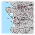
The project
resulted in the creation of a working model of the cellular network in the GVRD.
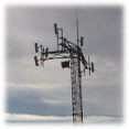
The model offers the user the ability to adjust many variables and see how the
network responds. These variables include range of towers, capacity of towers,
time of day, several traffic flow variables, number of cell phones in use, and
the location of any non-functional towers.
The model was then combined with an earthquake hazard model to
predict potential network problem areas in the event of a earthquake.
This web site provides an overview of this project, the project results and provides suggestions
and direction for further work in this area.
Note: Tan coloured links have a glossary entry.
|