Background Information
Introduction
This project was conducted by the Tsunami Vulnerability Consultant Group on behalf of the City of Port Alberni. The client requested information on the tsunami risk faced in Port Alberni based on road networks, elevation, population density, warning systems, and demographic attributes of the city. Another request was the recommended placement of two additional warning sirens to supplement the existing four. In consultation with the City, the Tsunami Vulnerability Consultant Group identified key analyses to be conducted and specific cartographic outputs to be produced.
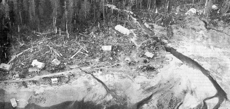
Our scenario is an M9.0 subduction megathrust earthquake with waves arriving 5-60 minutes after shaking is felt. Tides and time of day are random and the largest wave is expected to cause run-ups of over 20m in depth. Bridges may or may not have been damaged during the earthquake which affects the road network analyses
Defining Risk
Defining risk, vulnerability, and hazards are important to reducing ambiguity and improving the quality and intelligibility of our analysis. Dr. John Clague notes that risk is typically defined as the physical hazard multiplied by the social vulnerability. This study combines topographic features and knowledge of natural processes with demographic features and knowledge of how these are directly impacted by tsunamis. The literature defines vulnerability as the susceptibility of a community to a hazard, the product of social behaviours, actions , and patterns, as functions of class, marginalisation, economic, and political powers, or as the confluence of ecological, political, and developmental risks to humans. Vulnerability is necessarily difficult to define because it is rooted in the specific experiences of people and varies across space and time. This is a relevant concern for tsunami studies that must synthesise data collected globally from the poorest villages of Indonesia to the most resilient beach towns of California. The specific vulnerabilities and risk factors used for this study are explained in detail later.
Defining Tsunamis
The Pacific coast of Vancouver Island is particularly susceptible to a large mega-thrust earthquake as well as the secondary effects of a tsunami or harbour wave. This study is concerned not just with earthquake-generated tsunamis, but specifically with tsunamis generated from 'subduction megathrust earthquakes' with a moment magnitude exceeding M9.0. These seismic events have occurred twice in the past 1100 years and would have dire consequences for coastal communities on the west coast of Vancouver Island.
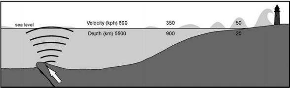
Tsunamis have exceptionally long wavelengths relative to wind driven wave or swells and are generally undetectable in open ocean despite travelling at up to 800 km/hr. It is only when approaching shorelines that waves begin to increase in amplitude. Tsunamis have exceptionally long wavelengths relative to wind driven wave or swells and are generally undetectable in open ocean despite travelling at up to 800 km/hr. It is only when approaching shorelines that waves begin to increase in amplitude.
Study Area
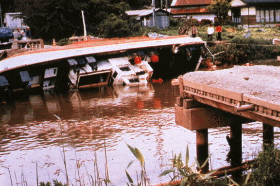
Port Alberni is a town of about 35,000, 100km inland from the west coast of Vancouver Island. It is served primarily by an east-west running provincial highway. It is located at the river delta of the Somas River at the end of the narrow Alberni Inlet. It has a coastal geometry that amplifies and funnels tsunami energy further inland resulting in more severe run up effects.The 20m inundation zone used in earlier Port Alberni planning is a conservative estimate with 30m being a more likely outcome. There are many industrial activities near the water such as sewage treatment, paper processing, and fishing, which pose a risk but are not included in our analysis. There are several Indian Reservations located throughout the study area that withhold statistical data and cannot be included in our analysis directly.