


Go to "Revisiting Frederick Catherwood's Cities of the Maya"
Camera Lucida, Lithographs, and Site Documentation in the 1840s
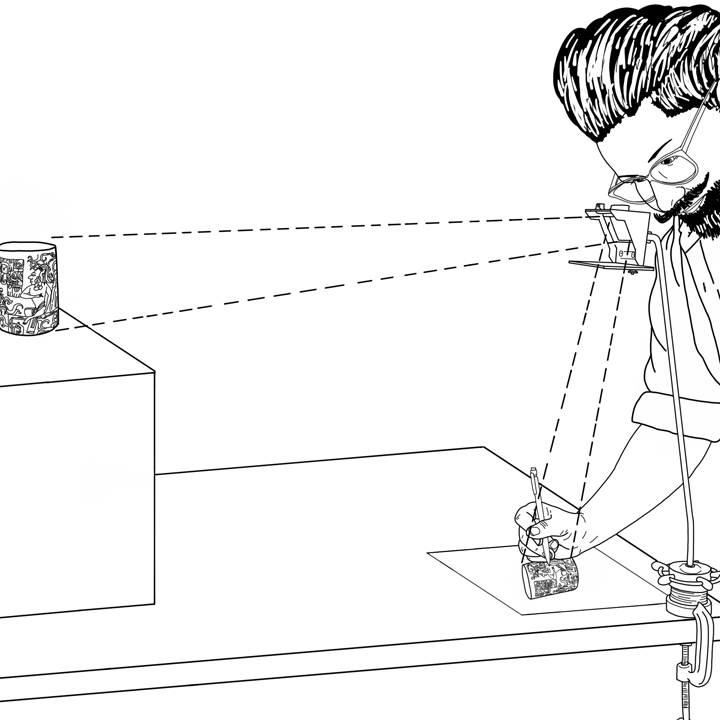
Armed with pencils, pens, paint, paper, sketchbooks, and drawing board, Frederick Catherwood was determined to capture the art and architecture of the Maya world accurately. Thus, he brought the latest technology: the camera lucida, a device that uses a prism to reflect the landscape onto a traceable surface. Romantic Era influences are apparent in his use of light and colour, and the styling of plants and animals, but his renderings of Indigenous designs is always precise.
Once Catherwood completed a sketch, he stored it safely from the elements until they arrived back in New York, where the images Stephens used for his book were lithographed (etched into stone, inked, and transferred to clean paper) and published. Catherwood later published his own folio in London, where he had lithographs and (coloured) chromolithographs produced locally. His unpublished works and entire collection of Maya artifacts were lost in a fire in 1842, except a few stone artifacts that had been delayed in shipping from Uxmal.
Catherwood also took daguerreotype views (early photography) as these had become comercially available by the time of their second expedition. His illustrations were preferred to the daguerreotypes because limited light in jungle cover rendered the photographs less detailed than Catherwood’s handiwork. The printed daguerreotypes were destroyed in the same fire that took their artifacts in 1842. Catherwood’s lithographs thereafter were the only record of many Maya sites, buildings, and artifacts.
Catherwood and John Lloyd Stephens' goal was to discover and record all the information they could about ancient Maya cities. Many of the sites they visited had been reclaimed by the forest, visible only as mounds and hills covered in vines and trees. The men hired workers to help clear and excavate the sites and artifacts that were hidden under hundreds of years of growth. All of the buildings and stela they uncovered were measured and mapped with written desciptions of their style, adornments, and location. This information supplemented Catherwood's illustrations and provided a platform for scholars and enthusiasts who were interested in learning about or visiting the sites at a later time. Their documentation also provide information about artifacts that have since been lost for various reasons such as erosion, looting by foreigners, and repurposing material.
Like Catherwood, archaeologists today are careful to meticulously document, measure, describe, and map all of their finds. Technological developments such as digital cameras, GPS, and LiDAR have changed field methodology since Catherwood’s time, but archaeologists are still very detail oriented. Everything made or altered by people (anthropogenic) is labelled and documented, especially for large restoration projects like reassembling Maya pyramids.
The photographs below were taken by Dr. Barbara Winter in 2013 at the Rastrojón archaeological site about 2KM from Copán, in western Honduras. Note the various stages in each photograph. Some photos show the site's ruins. Note the way the tree roots have moved and broken stones. Erosion from rain and looting are other potential threats to the integrity of these sites. Other photographs show stones that are labelled and have been moved for temporary storage. Each of these will have been documented in situ before the archaeologists moved them. That is, their location on a map, the direction they face, the position and elevation in a grid, any surrounding objects such as tree roots or other stones accounted for, and any other information found in association with the stone documented. This information is used for the restoration, and also for research purposes such as learning Maya building techniques and determining the origin of the stones and quarries.
Images from Rastrojón, Honduras, taken by Dr. Barbara Winter in 2013. (Accession numbers left to right: 2013.024.044, 2013.024.045, 2013.024.048, 2013.024.052, 2013.024.075, 2013.024.080, 2013.024.083.)

Content Navigation
- Camera Lucida, Lithographs, and Site Documentation in the 1840s
- Political Climate and Reception in Central America
- Copán, Honduras (1839-1840)
- Quiriguá, Guatemala (1839-1840)
- Palenque, México (1839-1840)
- Uxmal, México (1839-1840 and 1841-1842)
- Labná, México (1841-1842)
- Chichén Itzá, México (1841-1842)
- Tulum, México (1841-1842)
- References
- Colouring Book

© 2018 SFU Museum of Archaeology & Ethnology, created by Jackie La Mouri. Photographs courtesy of Barbara Winter, drawing by Carmen Kors.