Earthquake Early Warning Systems Modeling for North Vancouver
A Geography 355 Final Project by Tom McKay
How P-Wave Sensors Work
When an earthquake occurs, energy is released from its focus or hypocenter underground. Energy radiates outwards from this point in 3 types of waves: P-waves, S-waves, and R-waves. P waves travel the fastest and cause very little shaking, while the damaging S-waves and R-waves lag behind.

In British Columbia, a typical P-wave velocity would be 6.2 km/s while an S-wave speed would be around 3.6 km/s. This lag time between the arrival of P-waves and S-waves is integral to EEWS, and dependent on the location of the hypocenter an EEW system could provide from several seconds to several tens of seconds of warning before the strong motion from a large earthquake arrives. In the incident of a Cascadia Subduction Zone megathrust earthquake, 1/2 minute to 5 minutes of warning to urban centers are possible depending on quake starting point and location. The sensors are also able to forecast the chance of an M 7.0+ growing to an M 9.0+, and provide enhanced tsunami forecasts with integration with NOAA.
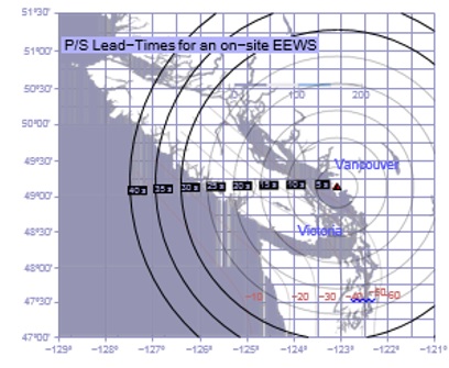
The intial P wave carries information about the size of the earthquake, and estimation of this size from the P wave an estimation can be made about the strength of the S wave destructive shaking. In an EEWS, an on-site P-wave sensor will be deployed and it will ideally initiate action before the arrival of damaging S-waves and R-waves. These sensors and systems have been activated during several earthquakes since 2007, and they have related accurate data about the magnitude, source location, and intensity of an earthquake at about 3.8 seconds after the arrival of a P-wave at nearby stations. Pictured below is an image displaying theoretical lead times for the already implemented on-site EEWS at the George Massey Tunnel - S-waves from an earthquake near one of the circles lag P-waves by the number of seconds indicated at the flag for the respective circle.
EEWS are networked, and P-wave sensors at various locations relay information to a central location. The bigger and more far-reaching the network of sensors is, the more accurate the analysis from the central location will be including a reduction in the incident of false alarms.
Features of Vancouver's EEWS
- Readings from sensors in Vancouver are relayed to a computer system at UBC which pools data from sensors at multiple sites to determine whether an earthquake alert needs to be issued. This system is called the British Columbia Smart Infrastructure Monitoring System, or BCSIMS
- These systems improve the post-earthquake inspection system, and help to determine the extent of damage and safety of school buildings using an automated prioritization program for determining the order for inspecting damaged school buildings
- Structural health monitoring as the result of EEWS allows for reduced delays in post-even reopening of schools
- Creates the backbone for an Earthquake alarm system, allowing students and staff time for duck and cover protection
- Data pooled at BCSIMS can be used to improve the post-earthquake emergency response and prioritize respsonse times to schools that need it most
Rationale for Desired Features of NVSD EEWS
- Reliability is an incredibly important component of any early warning system, and redundancy makes a system ore robust.
- It is therfore desirable to have as many sites as possible built into the EEWS network, across a wide variety of areas. North Vancouver School locations have varying levels of Earthquake vulnerability, and the system should be as diverse as possible to provide more accurate models.
- The distribution or layout of the proposed instrumentation should be logically designed to monitor the most meaningful quantities.