Earthquake Early Warning Systems Modeling for North Vancouver
A Geography 355 Final Project by Tom McKay
MCE Weighting and Rationale
For my analysis I performed a "Fuzzy Multi-criteria evaluation" or MCE. I opted for user defined weights based on the extensive research I did for the project, and my desired output. I wanted to find schools that, under current circumstances, would be difficult to get information on or get emergency services to were a megathurst earthquake event to occur today.
To achieve this goal I assigned the heaviest factor weights to "emergfuzz", which assigned values to pixels based on their distance from emergency response routes, and "liquefuzz", which assigned values to pixels based on the liquefaction risk to the surface geology value at that location. The weights appear as follows:
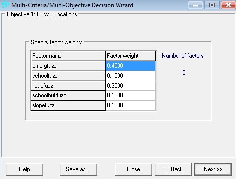
What this produced was an output map that would assign values between 1-255 based on how suitable they were in meeting my criteria, with higher values indicating higher suitability. The most suitable locations based on my weights are locations that are far from emergency response routes and on soils prone to liquefaction. Schools that are nearly equidistant from emergency response routes and on the same soil types then have varied values based on their seismic update status, proximity to other schools, and proximity to slopes that are succeptible to landslides. In my model I prioritized schools without seismic updates for EEWS as knowing their structural status would be paramount in planning a post quake rescue response.