
Fish Traps
By Dana Lepofsky
When socially and economically complex peoples are described in introductory Anthropological textbooks, Northwest Coast peoples are always given as the exception to the rule. Similar to most complex societies world-wide, they traditionally had hierarchical social systems, lived in large permanent villages for all of most of the year, and had high population densities. What is unique about Northwest Coast societies, however, is that the economic basis for this complex social system did not involve full scale agriculture. Northwest Coast peoples were hunter-gatherer-fisher folk, who, through a well developed system of resource management and ownership, were able to harvest and process enough food to create surplus that was used in trade, to finance the elaborate ritual systems, and to feed the people throughout the year when fresh food was not available.
Elaborate fish traps, like the one at Marshall’s Beach, were a central component of the elaborate social and economic system of Northwest Coast peoples. Archaeologists know little about the development of this amazing technology. The oldest recorded fish weir, dating to over 5000 years ago, is located in a large mudflat near Vancouver. It was constructed of wooden stakes and nets of various size openings, which was used to catch a variety of fish species (and any other animals who were attracted to the fish). Sometime in the past 2000 years or so, stone fish traps show up on the coast, but they become most common after 1200 years ago, when we see other changes in social and economic systems coast-wide. Based on the artifacts eroding out of the large midden at Marshall’s Beach, the Marshall Beach fish trap also dates to a similar time frame.
Archaeologists know even less about how the stone fish traps were used. Currently, someone is working with Heiltsuk elders of Bella Bella, where the highest density of fish traps on the coast have been recorded, to find out details of how their traps worked. We do know that most fish traps were some combination of stakes, nets, baskets, and stone alignments. Some, like one located in the bay just to the east of Marshall’s Beach, were composed of relatively simple linear arrangements of rocks and nets spanning a bay or a stream entrance. In the more complex systems, like the one at Marshall’s Beach, we are probably looking at a system that has been added to and changed over time, so not all the alignments we see would have been in use simultaneously. Simple and more complex stone fish traps and wooden fish weirs are located in other bays on Lasqueti and on the neighbouring small islands.
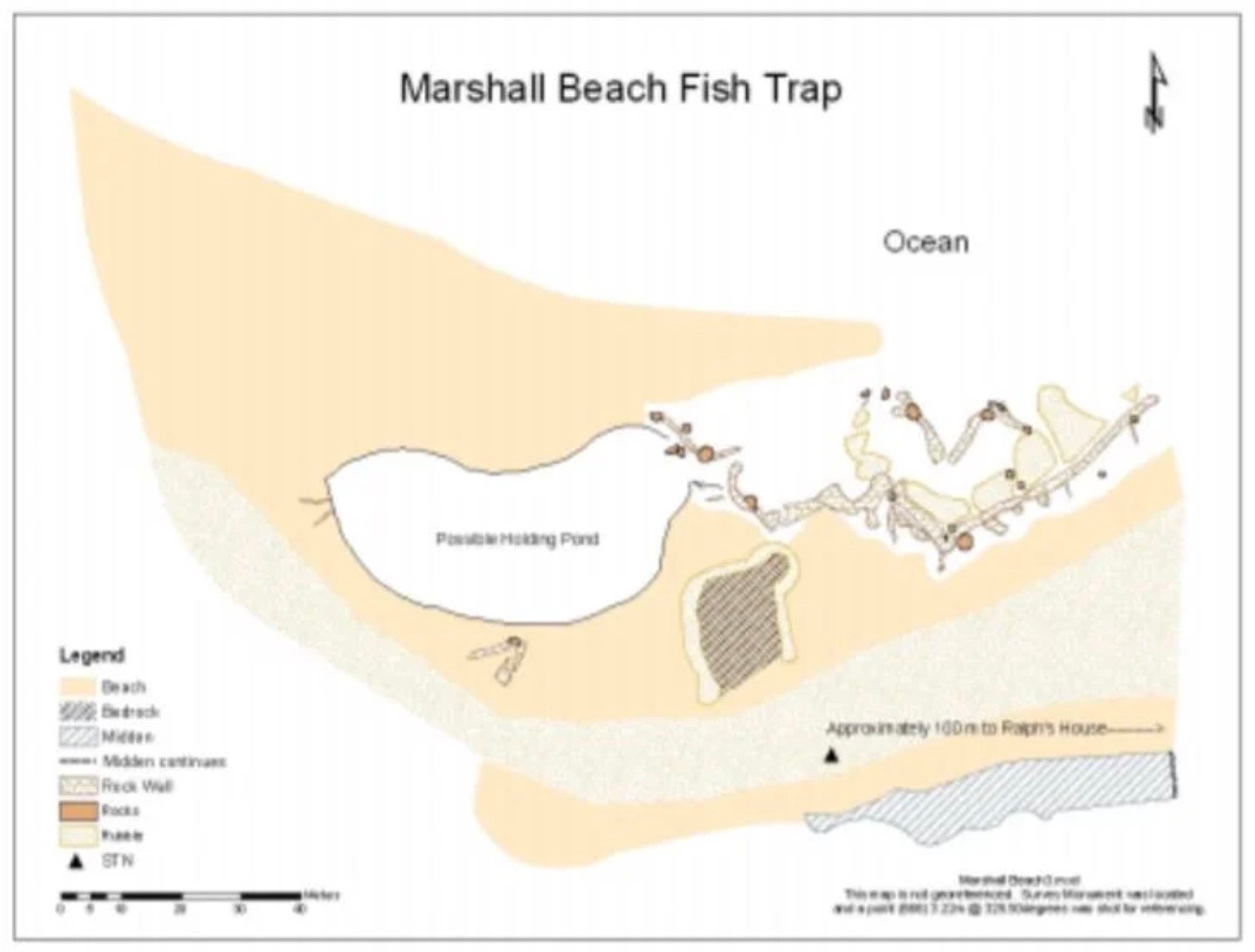
The map you see here of the Marshall’s Beach Fish Trap, represents the basic features of this incredibly complex feature. The data for the map was collected over two low-tide days in September. Sue W., Peter J., Ken L., John L., various kiddos, my GIS-mapping friend extraordinaire, Susan Formosa, and I used a fancy laser surveying machine to collect the hundreds of data points that defined the major outlines of the trap. We raced the tide to gather as many points as possible. At the end, we collected some of the points from a canoe and stripped off our pants to wade out to some rocks that were fast being covered by the in-coming tide. When the tide is fully in, there is no sign of this amazing ancient system.
Once we started mapping, it didn’t take us long to realize that most of the rocks on that very beautiful beach had been moved by people as part of this incredible engineering feat. There are several prominent features to the trap. A long, 3-5 course stone wall defines much of the eastern portion. To the south of this wall are various smaller walls coming off it at right angles, presumably that had nets across them (forming small pens?). On the opposite side of the wall are large clusters of rubble, which have been pushed together to create channels between them. In many cases these channels match up with the smaller walls. A major feature of the system is a large circular, rock-free depression that holds water even at the lowest tide. Rocks surrounding the depression have been pushed up along the beach edge, forming an even larger, circular depression when the tide is higher. We think these are holding ponds for trapped fish.
Throughout the trap (and in many traps on the coast), are funnel-shaped alignments, with the small side of the funnel facing the in-coming tide. These funnels lead into the possible holding ponds. When the tide comes in at Marshall’s Beach, the water flowing through these funnels is so strong that you literally can not stand up near them. Don McDonald says that sockeye, on their trek to the Fraser River to spawn, hang out in the calm waters in front of Jelina Island, waiting for the right tide. When the tide floods, the fish would have come closer to shore and then would have been drawn into the rush of water going through the funnels. We suspect that one-way traps were placed across the openings of these funnels. In the in-coming tides, salmon were funneled in and then trapped in the holding pens, where they could be processed for immediate and future consumption. These holding pens are an ingenious way of taking care of the “bottle neck” that Northwest Coast peoples faced during peak salmon runs: how to process fish quickly enough before it rotted.
Building and maintaining a trap of this size and complexity, and managing the huge amounts of fish that it was capable of harvesting, required a high level of community organization. The head or heads of the elite households likely managed the trap on behalf of the community members. I don’t know how many people could have been supported by the trap, but judging from the size of the nearby midden, the village was a substantial size.
