- Home
- Project
- Project Updates
- Mural and Exhibit Opening, May 2025
- Fall 2024 Update
- Layered Histories Archival and Website Project
- Intertidal Community Day 2023
- Cultural Burning Ceremony 2023
- Tla'amin Oct 2022
- Summer 2022 Recap
- Archaeological Field Work Aug 2022
- Plaque Event July 2022
- Archaeological Field Work September 2021
- Intertidal Community Day August 2021
- Our Logo
- Project Updates
- Archaeology
- Local Planning
- Education and Resources
- Our Team
- FAQs
Local Planning
Along with doing archaeology and engaging with local communities, members of the XLAP team are exploring how we can improve archaeological heritage conservation through policy and planning. We are seeking to do this through an in-depth understanding of existing policies and recommendations for how they may be improved, and by conducting research to better understand the design and implementation of Indigenous-led heritage policies. This involves researching how local planners interact with and manage Indigenous cultural heritage and understanding the policies that govern heritage management in BC.
Read a summary of the results of some of our work with local planners.

Xwe'etay is within the jurisdiction of three local governing bodies: the Tla'amin Nation, the Qathet Regional District, and the Islands Trust.
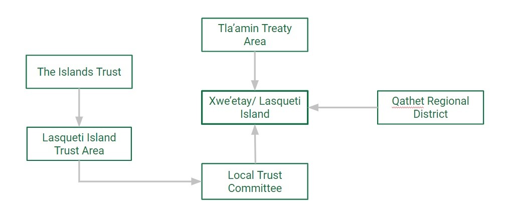
The Islands Trust acts as the primary land use planning authority at Xwe'etay. The Trust has jurisdiction over many of the islands in the Salish Sea and each island or small group of islands is considered a Trust Area. Each Trust Area has a local Trust Committee, which consists of two elected local island residents and an appointed chair. Trust committees engage with island residents to manage land use, set goals, and design policies and bylaws.
All the local Trust committees across the entire Trust area make up the Trust Council. In addition, the Islands Trust has a Regional Planning committee, the Trust Conservancy, and other branches which manage various regional services.

The Qathet Regional District has 5 electoral areas plus the City of Powell River on the traditional ancestral lands of the Tla’amin, shíshálh, Klahoose and K’ómoks First Nations. The qRD extends along the Sunshine Coast from Saltery Bay to Malaspina, inland to Toba Inlet, plus Texada, Savary, and Xwe’etay/ Lasqueti Islands in the Salish Sea.
Xwe’etay/ Lasqueti Island is electoral area E within the qRD. In electoral areas A, B, C, and D, the qRD provides land use planning services in addition to other local government responsibilities, such as emergency preparedness, waste management, utilities, regional parks and recreation, health services, and social planning. The City of Powell River and the Tla’amin Nation have their own land use planning departments, and the Islands Trust is responsible for planning at Xwe’etay.
The qRD also provides heritage conservation services in the City of Powell River and electoral areas A, B, and C. For a full list of services allocated to each electoral area and Powell River, click here.