Summer 2022 Recap
The following is reprinted from the Lasqueti Island Nature Conservancy's Fall/Winter 2022 newsletter. Visit the Lasqueti Island Nature Conservancy's website.
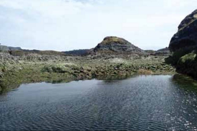
Clam Garden on Boho Island.
Photo: Katie Dirks
There was a time–not that long ago on the scale of such things–when the marine intertidal zone flourished, supplying on-going abundant and reliable foods for the many thousands of Indigenous peoples who lived along the north Pacific coast. In recent years, our intertidal ecosystems have experienced a decline in both species abundance and diversity. The decline has to do with a myriad of factors including deposition of silts from upland clearing, dragging of logs through eelgrass beds, the introduction of invasive species (e.g., the Japanese oyster) and various kinds of foreshore development.
Another major factor contributing to shifts in intertidal abundance and diversity is the effects of removing the people who actively stewarded their lands and seas for thousands of years to ensure food harvests into the future. Oral traditions, memories, and the archaeological record demonstrate the extent to which Indigenous peoples in this region and throughout the Pacific have intentionally managed the intertidal landscape. Region-wide practices include selective harvesting (limiting when and what), removal of predators, and maintaining healthy spawning and growing conditions by tilling, adding sediment, and by creating or removing barriers. For most Pacific Coast Indigenous peoples, these practices were embedded in age-old systems of tenure, governance, and spiritual beliefs that determined the proper way to interact with the intertidal landscape.
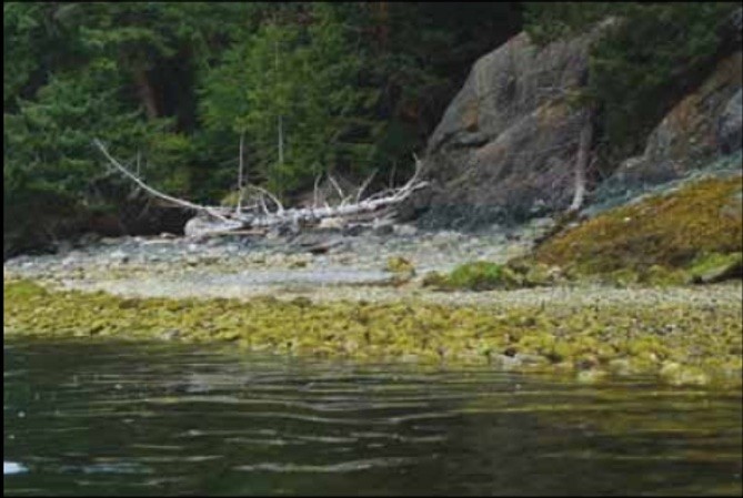
One of the goals of the Xwe’etay/Lasqueti Archaeology Project (XLAP) is to map the temporal and spatial extent of all the ancient Indigenous settlements on Xwe’etay in relation to their surrounding land and seascape. Over the summer this involved timing our shoreline surveys for the lowest low tides in May – August so that we could record the fish traps, clam gardens, and other intertidal features associated with the many Indigenous settlements around the island. Prior to our survey, only a few fish traps had been recorded, but not in detail, and no clam gardens were known from the island. This is because many of these features are under water for all but a few daylight hours every year.
And boy, our Xwe’etay intertidal surveys did not disappoint! We found an intertidal management feature on almost every beach we visited, especially on the northwest end of the island where most of the ancient settlements are located. For instance, False Bay is lined with ancient settlements (visible today as shell platforms on which houses were built). Associated with these settlements are rock features, lining the foreshore, that are the remnants of the once carefully managed intertidal landscape.
At the lowest levels of the intertidal zone are clam gardens (wúxwuthin in the Northern Coast Salish language). These are rock-faced terraces created by Indigenous people to expand and improve clam habitat at the zone where littleneck and butter clams thrive. Our work on Quadra Island has shown that some of these gardens are almost 4000 years old and that they provided a sustainable and abundant source of clams for generations. Our experiments show that clam gardens have 2 - 4x more clams than non-garden beaches, and they increased clam productivity by 150 – 300%. On northern Quadra Island, by building clam gardens on rocky substrates that previously had no clam habitat, people increased the amount of clam habitat in the whole landscape by one third.
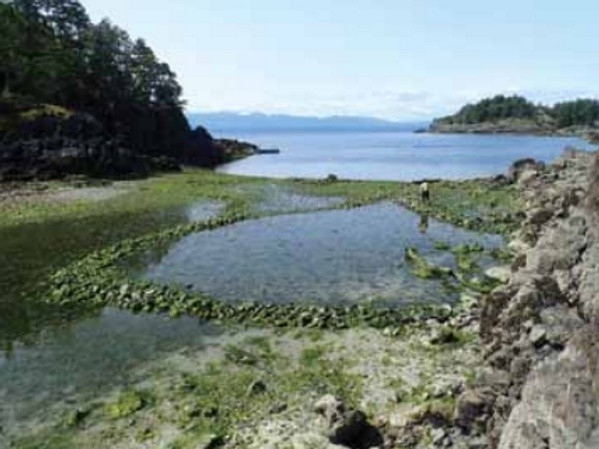
Calm garden on Jedediah in Bull Pass. The top of the terrace is at 1.4m above the zero tide. This is too high to support clams today, indicating that this is likely an older wall, built during times of higher sea level.
Photo: Dana Lepofsky
We also learned on Quadra that since ancient sea levels have been dropping for the last many thousands of years, we can use the height of the wall above a zero tide as a relative measure of age. That is, older garden terrace walls were built when sea level was higher than present, and they are now too high in the intertidal to support clams. On Xwe’etay, we found gardens that were as high as 1.4 meters above the zero tide. These are too high for native clams today and, based on our work elsewhere, may have been constructed and used over 1500 years ago. On the other extreme, there are garden terraces that are very low in the intertidal, sitting at about 30 cm above the zero tide. These low terraces were likely built to cultivate intertidal species that thrive in the lowest intertidal zone, such as horse clams. Given their tidal level, these gardens can’t be more than a few hundred years old. What is particularly neat is that some of the gardens are multi-terraced – so they track how people shifted the location and height of the wall to maximize clam production in changing ocean conditions.
Just a bit higher in the intertidal zone are a variety of carefully engineered fish traps and holding ponds. The rock walls were likely used as the foundation for wooden “fences” that would have facilitated trapping and releasing fish at various tidal levels. These have several shapes, including a form that, to my knowledge, is unique to this area: a “teardrop” with a long lead line. We recorded this form in two different locations and not only is the form identical in both places, but the size varies only by a meter or so. Remarkable engineering. We suspect, based on their placement, that these were used to trap herring.
The degree to which entire intertidal landscapes were altered and managed is even more remarkable than the variety of intertidal feature forms used. In subtle and ingenious ways, the ancestral peoples of Xwe’etay took full advantage of the natural abundance of the extensive intertidal flats between islets. In some areas, we found many small rock walls built between bedrock outcrops; these were placed in such a way to hold water, to funnel fish, or to raise the level of the beach. One feature often blended with the next and with the “natural” landscape such that it was not uncommon for us to find it difficult to put boundaries around the “archaeological site”. In the end, we often, and appropriately, recorded the entire intertidal flat as a single archaeological site to reflect the landscape scale of the traditional management practices.
In mid-August we were pleased to share some of the magic of these ancestral marine management features with our neighbours from Tla’amin and Qualicum Nations.
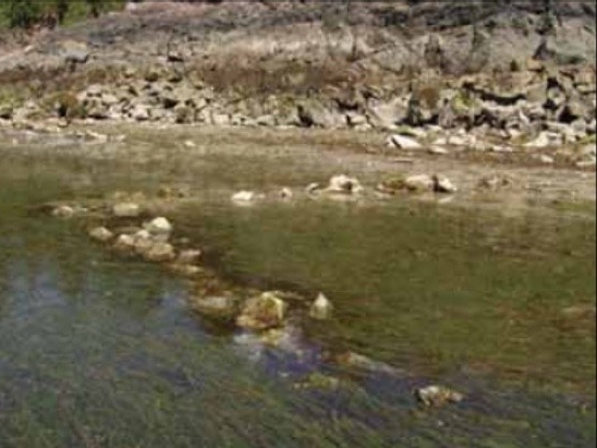
Teardrop fish trap and lead line in False Bay, possibly for capturing herring. It is nearly identical in shape and size to one on the Jervettes (the islets next to Jervis Island near Tucker Bay).
Photo: Katie Dierks
Other forms of fish traps are common on Xwe’etay, including this V-shaped form in Heron Bay.
Photo: Dana Lepofsky
About 20 people from these Nations joined about 70 Xwe’etay islanders to share food, stories, songs, and fun during a low-low tide window. We marveled at the degree to which Indigenous peoples tended the marine landscape. For many settlers who have lived here a long time, it opened their eyes to a new way of seeing the island’s deep history.
Next summer, the XLAP team will continue to explore the Indigenous archaeological heritage of Xwe’etay. We hope to host more inter-community events where all people can come together to celebrate Xwe’etay’s deep history.
To learn more about intertidal marine management on the northwest coast and elsewhere, visit: www.seagardens.net and www.clamgarden.com
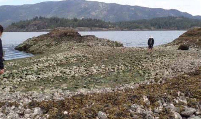
Complex of stone walls on the intertidal on Boho Island, showing the extent to which the intertidal landscape was managed.
Photo Katie Dierks