
- About
- Research
- Prospective Students
- Current Students
- News & Events
- News
- Events
- News & Kudos Archives
- 2024 Archives
- Professor Nicholas Blomley Honored with the Community-Engaged Research Achievement Award
- Graduate Students Claire Shapton and Marina Chavez Honored with the Community-Engaged Graduate Scholar Award
- Applications now open: 2024 ESRI Canada GIS Scholarship for SFU
- Associate Professor Rosemary Collard achieves 13th place on SFU Altmetric List
- The PEAK feature: GSU hosts inaugural RANGE conference
- Gabrielle Wong wins First Prize in 2023 Student Learning Commons Writing Contest
- Gabrielle Wong receives Warren Gill Memorial Award
- Professor Nick Blomley receives Warren Gill Memorial Award for Community Impact
- Geography Student Union recipient of the FENV 2024 Changemaker Awards
- Senior Lecturer Tara Holland reveals the secret sauce of great teaching
- Senior Lecturer Tara Holland Receives SFU 2023 Excellence in Teaching Award
- Thesis Defence - Congratulations to Bright Addae
- GIS undergraduate students participate in the Canada-wide 2024 AppChallenge competition
- Senior Lecturer Andrew Perkins Receives SFU 2024 Dean's Award of Excellence in Teaching
- Congratulations to Alysha van Duynhoven, Canada's 2024 ESRI Young Scholar
- Thesis Defence - Congratulations to Robert Ehlert
- Thesis Defence - Congratulations to Stephan Nieweler
- Eugene McCann writes on "livable cities" in The Tyee
- Tiana Andjelic wins the 2024 SFU ECCE GIS Scholarship Award
- Thesis Defence - Congratulations to Marina Chavez
- Thesis Defence - Congratulations to Mia Fitzpatrick
- Thesis Defence - Congratulations to Lan Qing Zhao
- Thesis Defence - Congratulations to Tyler Cole
- Thesis Defence - Congratulations to Benjamin Lartey
- Thesis Defence - Congratulations to Olivia Nieves
- Thesis Defence - Congratulations to Max Hurson
- Thesis Defence - Congratulations to John Sykes
- Farewell to Robert "Bob" Horsfall, Associate Professor
- Thesis Defence - Congratulations to André Araújo
- SFU Geography welcomes ethnobotanist, Leigh Joseph, as professor of Indigenous geographies
- Physical Geography September: What is Physical Geography?
- Alysha Van Duynhoven communicates award-winning research at international GIS conference
- How Dr. Tracy Brennand’s visionary leadership shaped the Department of Geography - a heartfelt thank-you
- Dr. Tracy Brennand honoured with the Canadian Association of Geographers (CAG) Award
- Thesis Defence - Congratulations to Jay Matsushiba
- Human Geography October: What is Human Geography?
- MA Student Joy Russell featured on CBC Vancouver
- Human Geography October: What is Urban Worlds?
- Ajay Minhas Receives 2024 Warren Gill Award
- Dr. Nadine Schuurman featured in SFU news article on Runnability
- GIS Month: What is Geographic Information Science (GIS)?
- Thesis Defence - Congratulations to Joy Russell
- Perspectives from students using ChatGPT in a large enrollment fully online GIS Course
- Motivations, Habits and Risks of using ChatGPT in the On-Campus Quantitative Geography course
- Thesis Defence - Congratulations to Ian McDonald
- 2025 Archives
- Thesis Defence - Congratulations to Negin Shooraj
- SFU Geography Alumni Sean Orr wins Vancouver council seat in byelection
- Rosemary Collard awarded 2024 SFU Excellence in Teaching Award
- SFU Students Designed and Developed a GeoApp as a Living Wage Calculator
- Undergraduate students team secures third-place in Canada-wide GeoApp competition
- SFU Geography Wins Big at 2025 CAG Annual Conference
- Thesis Defence - Congratulations to Alex Sodeman
- Thesis Defence - Congratulations to Tintin Yang
- In Memory of Leonard "Len" Evenden, Professor Emeritus
- Gabrielle Wong awarded 2025 Gordon M. Shrum Medal
- Dr. Bright Addae awarded 2025 Graduate Dean's Convocation Medal
- Congratulations to Alysha van Duynhoven for Teaching Assistant Excellence Award
- Wildfires to waterways: SFU Geography grad takes action to protect the environment
- Making a difference on and off-campus: student leader and changemaker, Gabrielle Wong, awarded SFU convocation medal
- 2025 Alumni Newsletter
- Kira Sokolovskaia wins the 2025 SFU ECCE GIS Scholarship Award
- Mapping a path to City Hall: SFU alumnus shares journey to becoming Mayor of New Westminster
- Thesis Defence - Congratulations to Alysha van Duynhoven
- Thesis Defence - Congratulations to Hannah Harrison
- Thesis Defence - Congratulations to Jade Baird
- Thesis Defence - Congratulations to Ashley Tegart
- Rethinking the World Map: Dr. Shiv Balram featured on CBC
- Thesis Defence - Congratulations to Véronique Emond-Sioufi
- SFU Geographers at the 2025 International Cartographic Conference in Vancouver
- When academic curiosity meets environmental purpose: new global environmental systems grad builds interdisciplinary foundation at SFU
- Alysha Van Duynhoven wins the 2025 SFU ECCE in GIS Student Associate Achievement Award
- Thesis Defence - Congratulations to David Swanlund
- Congratulations to Our 2025 Warren Gill Award Recipients!
- Thesis Defence - Congratulations to Baharak Yousefi
- Thesis Defence - Congratulations to Tara Jankovic
- 2024 Archives
- Alumni
- GEOG 162 - Canada
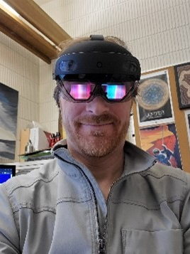
Research profile
I am a multi-disciplinary spatial visualization and spatial interface designer/developer/applied scientist in the Dept of Geography. I am a geographic information scientist with primary interests in 3D geographic visualization, 3D spatial interfaces, 3D data surveying, and applying these methods to real geographic challenges.
At the core of my research is the process of designing, developing and testing new geovisualization interfaces that respond to applied problems and challenges to characterize and understand the geometry and dynamics of complex spatial phenomena. My program of research is driven by how new enabling technologies facilitate powerful ways to characterize, visualize, experience and interact with geographic data.
I design, develop and deploy 3D geographic visualization, using augmented reality (AR), mixed reality (MR), extended reality (XR), , and immersive virtual reality (VR) systems. My work also involves the design of survey, capture, visualization and 3D analysis strategies, using laser scanning, structured light, photogrammetry, and structure-from-motion (SfM) methods.
I apply these technologies and techniques to respond to a wide range of spatial problems, including: climate change, sea level rise and adaptation; risk communication (tsunamis; earthquakes; mass evacuation simulations); coastal dynamics: coastal vulnerability; rapid-onset hazards; fluvial geomorphology; rigid-body slope mechanics; AI crowd simulations; 3D ecological monitoring on the seafloor (glass sponges); flood risk management in Canada; radiological exposure; digital cultural heritage and archaeological reconstruction; social justice; privacy and drone space analysis in 3D urban spaces; data processing, visualization and interfaces for off-world data, such as Mars.
Fields of interest
- Spatial interface research
- Mixed reality (MR)
- Augmented reality (AR)
- Extended reality (XR)
- Virtual reality and virtual environments (VR, VE) - Spatial computing (using physical spaces as experiential data visualization interfaces)
- 3D Geovisualization
- 3D GIScience
- 3D surveying and data collection
- Exploratory geomorphometry and archaeometry
- Critical theorization of interface-mediated information experiences, metaverses, cyborg theory,
- Telepresent interfaces
- Experiential information systems
Applied research themes
- Earth and space science informatics
- Climate change and climate futures visualization
- Environmental and ecological visualization
- Analytical archaeological geovisualization and interface development
- Geotechnical geovisualization and interface development
- Geovisual analysis and simulation of coronavirus
- Digital cultural heritage
- Social justice
Current Research Projects
Designing and developing 3D surveying infrastructure for ecological monitoring on the seafloor
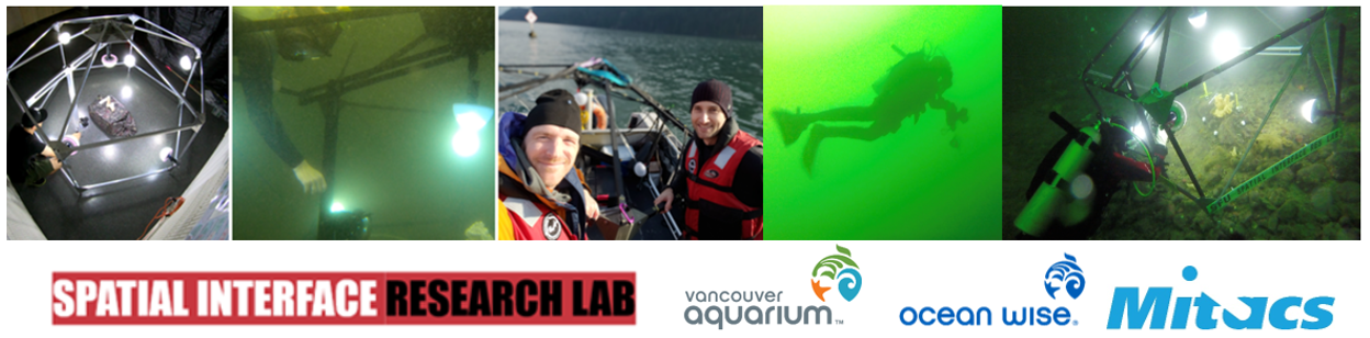
We designed, developed, and built an underwater rig that captures very high seafloor geomorphometry, for long-term ecological monitoring/eco-morphometry. The underwater rig was developed (in the dry) at SFU, and underwater in a large ocean-filled tank at DFO’s CAER research lab in West Vancouver. We developed empirical data science benchmarking protocols to assess the veracity of underwater photogrammetry, and successfully repeated deployment of complete, operational, benchmarked rig on the seafloor in Howe Sound, in support of Ocean Wise, Vancouver Aquarium, Coastal Ocean Research Institute (CORI). This work delivered new operational capability to our partners, and resulted in a new body of empirical research that establishes benchmarks for the data science of underwater surveying. This work was tweeted by SFU Research. See video:https://twitter.com/i/status/1063622899527892992
Experience-based design of scientific data visualization interface infrastructure
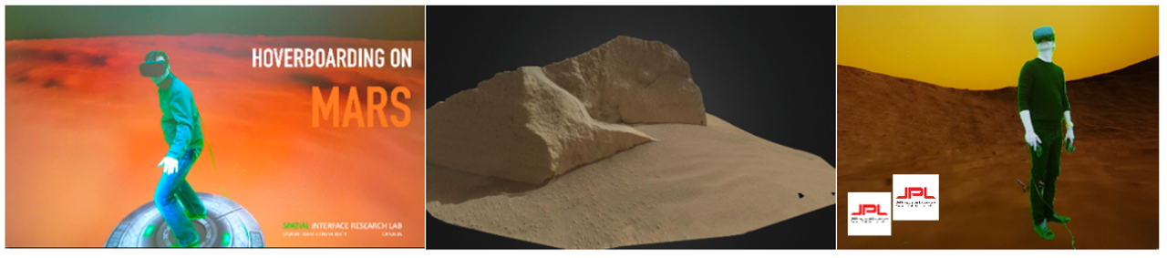
I am using the experience and insight of having designed/developed many 3D interfaces for many different spatial contexts – to inform the design and development of a new generation of scientific data visualization interface infrastructure at JPL. I am currently working on two vectors of this problem – exploring the scientific value proposition of emerging technologies across Earth and space science use cases; and developing the perceptual, cognitive and experiential design framework for integrating XR interface infrastructure for science data visualization into day-to-day science missions, in everyday lab spaces.
Developing analytical 3D tools for flood risk/policy visualization with Municipal Governments
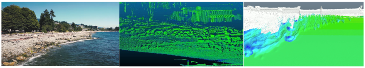
I work with local governments (such as West Vancouver, City of Vancouver) on coastal geomorphometric surveys and analytical risk visualizations. I also explore the implementation of virtual and mixed reality GIS interfaces to support and enrich the way municipal planners, analysts and policy specialists use, and understand complex datasets. In particular to investigate their capability to enhance perception and analysis of structural data relationships in three-dimensional geographic space. We are evaluating their capability to support/enhance flood risk data visualization and use.
Using VR, AR and MR visualization technologies in social justice research
Using 360 VR, we are making it possible for anyone to participate in a walking tour hosted by social justice experts; using immersive VR and tabletop AR, we are allowing users to walk through historical spaces of xenophobia and incarceration, constructed using fire insurance and ownership records; in real-world spaces we are creating holographic reconstructions of families being rounded up – to connect ourselves to the history of this landscape, the people who have moved through it, and the social injustices they have endured.
Between Worlds – demonstrating the potential of XR interfaces for digital cultural heritage
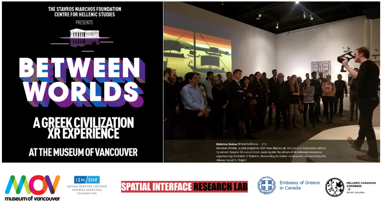
I designed and developed Between Worlds – a radical 3D interface-based exhibit, demonstrating a vision for future learning and engagement experiences with spatial data, geovisual experiences, digital cultural heritage. This work was funded by a grant from the Stavros Niarchos Foundation, and a partnership with the SNF Centre for Hellenic Studies, and the Museum of Vancouver. It demonstrates the potential and implications of transformative spatial information experiences in public education environments – using extended reality (XR), virtual reality (VR), mixed reality (MR), 3D data and simulation.
TV feature: https://youtu.be/OzDgtPuMMgo
Press/social media:
https://www.sfu.ca/hellenic-studies/newsroom/news/found-in-translation.html
For more information
See my research website: www.spatialinterfaceresearchlab.org
I welcome students interested in graduate research in all the areas noted above
Courses
Spring 2026
Future courses may be subject to change.