- About
- Research
- Prospective Students
- Current Students
- News & Events
- News
- Events
- News & Kudos Archives
- 2025 Archives
- Thesis Defence - Congratulations to Negin Shooraj
- SFU Geography Alumni Sean Orr wins Vancouver council seat in byelection
- Rosemary Collard awarded 2024 SFU Excellence in Teaching Award
- SFU Students Designed and Developed a GeoApp as a Living Wage Calculator
- Undergraduate students team secures third-place in Canada-wide GeoApp competition
- SFU Geography Wins Big at 2025 CAG Annual Conference
- Thesis Defence - Congratulations to Alex Sodeman
- Thesis Defence - Congratulations to Tintin Yang
- In Memory of Leonard "Len" Evenden, Professor Emeritus
- Gabrielle Wong awarded 2025 Gordon M. Shrum Medal
- Dr. Bright Addae awarded 2025 Graduate Dean's Convocation Medal
- Congratulations to Alysha van Duynhoven for Teaching Assistant Excellence Award
- Wildfires to waterways: SFU Geography grad takes action to protect the environment
- Making a difference on and off-campus: student leader and changemaker, Gabrielle Wong, awarded SFU convocation medal
- 2025 Alumni Newsletter
- Kira Sokolovskaia wins the 2025 SFU ECCE GIS Scholarship Award
- Mapping a path to City Hall: SFU alumnus shares journey to becoming Mayor of New Westminster
- Thesis Defence - Congratulations to Alysha van Duynhoven
- Thesis Defence - Congratulations to Hannah Harrison
- Thesis Defence - Congratulations to Jade Baird
- Thesis Defence - Congratulations to Ashley Tegart
- Rethinking the World Map: Dr. Shiv Balram featured on CBC
- Thesis Defence - Congratulations to Véronique Emond-Sioufi
- SFU Geographers at the 2025 International Cartographic Conference in Vancouver
- When academic curiosity meets environmental purpose: new global environmental systems grad builds interdisciplinary foundation at SFU
- Alysha Van Duynhoven wins the 2025 SFU ECCE in GIS Student Associate Achievement Award
- Thesis Defence - Congratulations to David Swanlund
- Congratulations to Our 2025 Warren Gill Award Recipients!
- Thesis Defence - Congratulations to Baharak Yousefi
- Thesis Defence - Congratulations to Tara Jankovic
- Thesis Defence - Congratulations to Christine Leclerc
- Thesis Defence - Congratulations to Kira Lamont
- Terri Evans: Researching homelessness in suburban communities
- Mapping change for people and the planet
- GIS Month: What is Geographic Information Science (GIS)?
- SFU GIS undergraduate develops real-time earthquake monitoring and hospital alert system
- Physical Geography student returns to SFU, dives into marine ecology, soils and GIS to map a new path forward
- SFU study searches Strava to reveal secrets to happier runs
- 2026 Archives
- SFU study searches Strava to reveal secrets to happier runs
- GIScience Students Become SFU’s First Team at National Geomatics Competition
- 2026 ESRI Canada GIS Scholarship for SFU
- Physical Geography student returns to SFU, dives into marine ecology, soils and GIS to map a new path forward
- SFU GIS undergraduate develops real-time earthquake monitoring and hospital alert system
- GIS Month: What is Geographic Information Science (GIS)?
- Mapping change for people and the planet
- GIS Team Crowned Champions of 2026 National Geomatics Competition
- Second-year MSc Student, Erin Fairley, has made it to the SFU 3MT Finals!
- Thesis Defence - Congratulations to Brandon Drucker
- In Memory of Ivor Winton
- SFU Students Create GeoApp to Reveal Transit Deserts and Oases Across Metro Vancouver
- Andrew Perkins receives 2025 Excellence in Teaching Award
- Krista Macaulay Receives Prestigious Trudeau Fellowship
- Human Geography Student Guneet Kaur Receives SFU Centre for Dialogue Award for Undergraduate Research
- Dr. Baharak Yousefi awarded 2026 Graduate Dean's Convocation Medal
- Thesis Defence - Congratulations to Scott Peters
- Gus Schiele wins the 2026 SFU ECCE GIS Scholarship Award
- GES grad maximizes interdisciplinary learning opportunities to tackle global challenges in conservation and sustainability
- Student Stories: Camille Dela Cruz
- Terrestrial ecosystem researcher joins SFU Geography to study future of forests under climate change
- 2025 Archives
- Alumni
- GEOG 162 - Canada

Jonathan Cripps
Program: PhD, Physical Geography
Supervisor: Tracy A. Brennand
Research: Reinterpreting the pattern and style of the last Cordilleran Ice Sheet deglaciation over the southern interior, British Columbia.
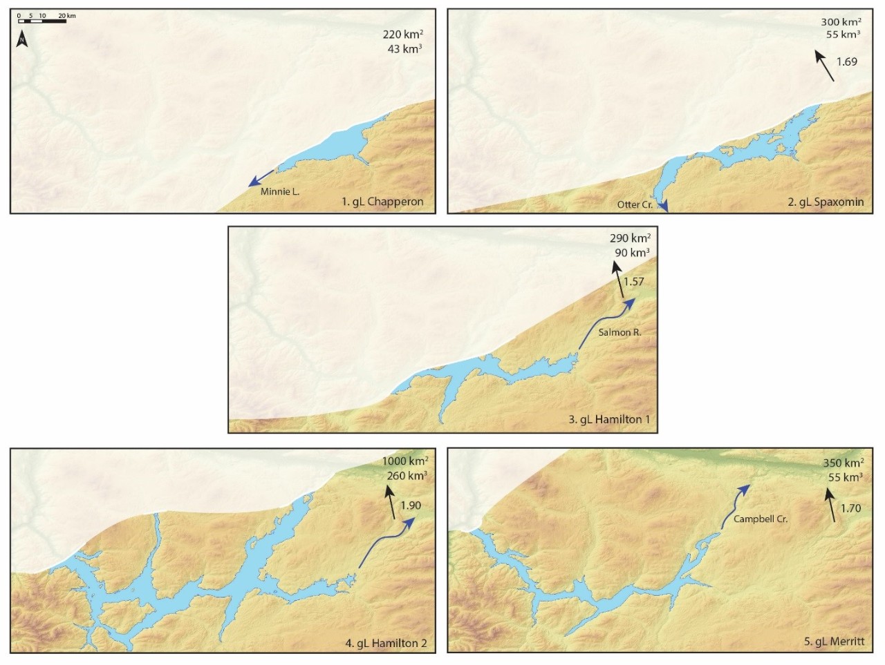
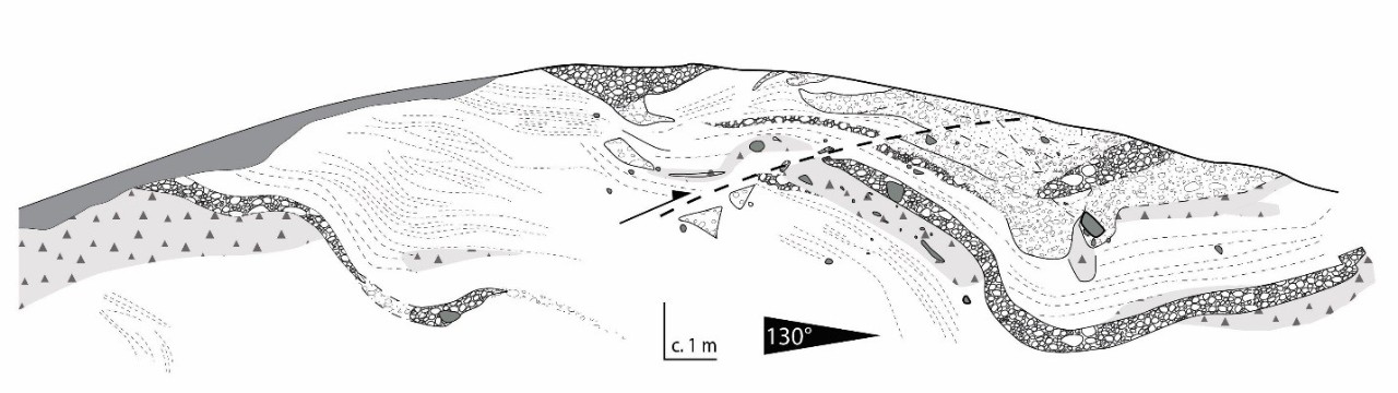
Reconstructions of former ice sheet deglaciation allow better anticipation of future ice sheet decay. The Cordilleran Ice Sheet (CIS), which existed over BC during the last glacial period to around 12,000 years ago, is currently considered to have deglaciated through vertical stagnation (top-down melting), though this has been challenged by recent studies. My research is a reinvestigation of the Nicola and Thompson river valleys in south-central BC, a key region in the development of the stagnation paradigm. I have reconstructed paleo-ice-dammed lakes from lake sediments and landforms throughout the valleys; these reconstructions have allowed paleo-ice margin positions to be identified, and these imply steady northwestward ice retreat to the Coast Mountains. Systematic and active retreat rather than stagnation is supported by the glacioisostatic tilts of the lake shorelines, which imply an ice surface slope up to the northwest, and several moraines and grounding lines within the region which suggest active ice retreat and minor readvances. These lines of evidence encourage a reinterpretation of CIS deglaciation in the southern interior as being systematic and active. Investigations of lake spillways (outflow channels) have revealed outburst flood sediment and landforms, improving understanding of post-glacial drainage network development in BC. I am currently attempting to hydraulically model these floods.
Teaching:
Sessional appointments:
GEOG 412 – Glacial Processes and Environments
GEOG 213 – Introduction to Geomorphology
TA/TM appointments:
GEOG 102 – Global issues in a Geographical Perspective
GEOG 111 – Earth Systems
GEOG 213 – Introduction to Geomorphology
GEOG 311 – Hydrology
GEOG 312 – Natural Hazards
GEOG 313 – Fluvial Geomorphology
GEOG 412 – Glacial Processes and Environments
Publications:
Thorndycraft V.R., Cripps J.E., Eades G. 2015. Digital landscapes of deglaciation: Identifying Late Quaternary glacial lake outburst floods using LiDAR. Earth Surface Processes and Landforms. Published online June 30 2015. DOI: 10.1002/esp.3780
Previous education:
BSc Physical Geography, Durham University, UK.
Dissertation: Diurnal variation in discharge and suspended sediment concentration in an ice-marginal stream, Sandsfelljokull, Iceland. Supervised by Dr. Andreas Vieli.
MSc Quaternary Science, University of London (Royal Holloway and UCL), UK.
Dissertation: Quantifying the palaeohydrology of Glacial Lake Milfield and its outburst flood drainage: Implications for landscape evolution of the Till Valley (NE England). Supervised by Dr. Varyl Thorndycraft.
Scholarships and awards at SFU:
- CANQUA Aleksis Dreimanis Doctoral Scholarship: 2015
- CGRG Olav Slaymaker Award: 2015
- INQUA Young Researchers Grant: 2015
- SFU President’s PhD Scholarship: 2015
- QRA Young Researchers Award: 2015
- BSG Postgraduate Research Grant: 2014
- GSA Graduate Student Research Grant: 2013
- SFU Special Graduate Entrance Scholarship: 2012